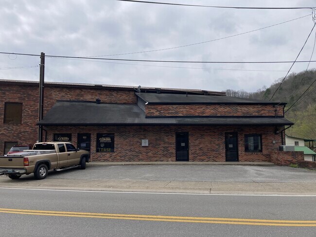
Property Record
2300 N Main St, Hazard, KY 41701
NEARBY LISTINGS FOR SALE OR LEASE
-
-
View all Hazard listings for lease on LoopNet.com
Property Detail
2300 N Main St
101-14-15-006.00
DB 252 PG 628
Countyproperty
Perry
AE
Kentucky
21193C0189E
0.14 AC
0
Kentucky East Area
2025
Other Market Areas
970400
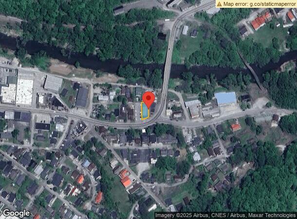
DEMOGRAPHICS near 2300 N Main St
1 Mile
3 Mile
5 Mile
2024 Total Population
2,979
9,981
14,633
2029 Population
2,944
9,770
14,186
Pop Growth 2024-2029
(1.17%)
(2.11%)
(3.05%)
Average Age
40
41
41
2024 Total Households
1,219
4,100
5,928
HH Growth 2024-2029
(1.07%)
(1.98%)
(2.95%)
Median Household Inc
$39,038
$47,630
$41,931
Avg Household Size
2.30
2.30
2.30
2024 Avg HH Vehicles
2.00
2.00
2.00
Median Home Value
$97,537
$99,077
$96,422
Median Year Built
1979
1980
1981
Nearby Places
Map Layers
Map Styles
 Street
 Aerial
- Restaurants
- Banks
- Shops
- Fitness
- Groceries
SALE & LEASE HISTORY
LISTING DATE
SALE/LEASE

Aug 19, 2021
For Lease
Apr 22, 2021
For Sale
Nearby Properties
Address
Land Use
TOTAL SIZE
Lot Size
Zoning
Address
Land Use
TOTAL SIZE
Lot Size
Zoning
Address
Land Use
TOTAL SIZE
Lot Size
Zoning
31.07 AC
Address
Land Use
TOTAL SIZE
Lot Size
Zoning
196,287 SF
19.65 AC
R
Address
Land Use
TOTAL SIZE
Lot Size
Zoning
90,000 SF
33.98 AC
Address
Land Use
TOTAL SIZE
Lot Size
Zoning
22 AC
Address
Land Use
TOTAL SIZE
Lot Size
Zoning
0.11 AC
Address
Land Use
TOTAL SIZE
Lot Size
Zoning
16,725 SF
R
Address
Land Use
TOTAL SIZE
Lot Size
Zoning
15,750 SF
Address
Land Use
TOTAL SIZE
Lot Size
Zoning
94,000 SF
11.50 AC
R
Address
Land Use
TOTAL SIZE
Lot Size
Zoning
6,000 SF
42 AC
Address
Land Use
TOTAL SIZE
Lot Size
Zoning
50,949 SF
5.35 AC
Address
Land Use
TOTAL SIZE
Lot Size
Zoning
Address
Land Use
TOTAL SIZE
Lot Size
Zoning
24,482 SF
18.30 AC
Address
Land Use
TOTAL SIZE
Lot Size
Zoning
32,390 SF
5.99 AC
Address
Land Use
TOTAL SIZE
Lot Size
Zoning
50,000 SF
1.62 AC
R
Address
Land Use
TOTAL SIZE
Lot Size
Zoning
41,874 SF
1.40 AC
R
Address
Land Use
TOTAL SIZE
Lot Size
Zoning
1,100 SF
0.89 AC
Address
Land Use
TOTAL SIZE
Lot Size
Zoning
2,068 SF
6 AC
Address
Land Use
TOTAL SIZE
Lot Size
Zoning
60,285 SF
3.66 AC
Address
Land Use
TOTAL SIZE
Lot Size
Zoning
38,496 SF
0.42 AC
Address
Land Use
TOTAL SIZE
Lot Size
Zoning
1.14 AC
Address
Land Use
TOTAL SIZE
Lot Size
Zoning
84.25 AC
Address
Land Use
TOTAL SIZE
Lot Size
Zoning
19,730 SF
4 AC
Address
Land Use
TOTAL SIZE
Lot Size
Zoning
7.43 AC
Address
Land Use
TOTAL SIZE
Lot Size
Zoning
12,238 SF
8 AC
Address
Land Use
TOTAL SIZE
Lot Size
Zoning
33,618 SF
16 AC
Address
Land Use
TOTAL SIZE
Lot Size
Zoning
9,500 SF
0.80 AC
Address
Land Use
TOTAL SIZE
Lot Size
Zoning
2.45 AC
Address
Land Use
TOTAL SIZE
Lot Size
Zoning
7.43 AC
R
The World's #1 Commercial Real Estate Marketplace
Connect with us
© 2026 CoStar Group
The information above has been obtained from sources believed reliable. While we do not doubt its accuracy we have not verified it and make no guarantee, warranty or representation about it. It is your responsibility to independently confirm its accuracy and completeness. Any projections, opinions, assumptions, or estimates used are for example only and do not represent the current or future performance of the property. The value of this transaction to you depends on tax and other factors which should be evaluated by your tax, financial, and legal advisors. You and your advisors should conduct a careful, independent investigation of the property to determine to your satisfaction the suitability of the property for your needs.