Property Record
2300 Redondo Ave, Signal Hill, CA 90755
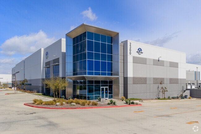

Property Detail
2300 Redondo Ave
7218-028-004
P M 405-73-76 LOT 1
Lightindustrial
LOS ANGELES
LBI
California
B and X Area of moderate flood hazard, usually the area between the limits of the 100-year and 500-year floods.
1
2025
8.78 AC
2025
Long Beach
574202
Los Angeles
204,767 SF
Los Angeles-Long Beach-Glendale, CA
NEARBY LISTINGS FOR SALE OR LEASE
DEMOGRAPHICS near 2300 Redondo Ave
1 mile
3 mile
5 mile
2025 Total Population
22,820
280,689
550,326
2030 Population
22,639
278,614
545,464
Pop Growth 2025-2030
(0.79%)
(0.74%)
(0.88%)
Average Age
38
39
41
2025 Total Households
8,832
107,954
203,755
HH Growth 2025-2030
(1.05%)
(0.90%)
(0.92%)
Median Household Inc
$97,725
$87,579
$91,008
Avg Household Size
2.50
2.40
2.60
2025 Avg HH Vehicles
2.00
2.00
2.00
Median Home Value
$775,559
$835,843
$790,189
Median Year Built
1979
1958
1958
Nearby Places
Map Layers
Map Styles
 Street
 Aerial
Layers
 Traffic
 Biking
Places
Listings with unknown addresses are not visible on the map
- Restaurants
- Banks
- Shops
- Fitness
- Groceries
PUBLIC TRANSPORTATION
AIRPORT
Long Beach (Daugherty Field)
Drive
Walk
Distance
Long Beach (Daugherty Field)
6 min
2.9 mi
John Wayne/Orange County
Drive
Walk
Distance
John Wayne/Orange County
26 min
20.3 mi
Los Angeles International
Drive
Walk
Distance
Los Angeles International
30 min
21.7 mi
Freight Ports
Port of Long Beach
Drive
Walk
Distance
Port of Long Beach
9 min
4.0 mi
SALE & LEASE HISTORY
LISTING DATE
SALE/LEASE

May 23, 2018
For Lease
Mar 06, 2024
For Lease
Nearby Properties
Address
Land Use
TOTAL SIZE
Lot Size
Zoning
Address
Land Use
TOTAL SIZE
Lot Size
Zoning
502,333 SF
21.89 AC
LBI
Address
Land Use
TOTAL SIZE
Lot Size
Zoning
402,342 SF
LBPD30
Address
Land Use
TOTAL SIZE
Lot Size
Zoning
266,158 SF
1 AC
LBPD30
Address
Land Use
TOTAL SIZE
Lot Size
Zoning
954,581 SF
50.09 AC
LBPD 19
Address
Land Use
TOTAL SIZE
Lot Size
Zoning
182,749 SF
LBPD30
Address
Land Use
TOTAL SIZE
Lot Size
Zoning
140,236 SF
9.21 AC
LBR4N
Address
Land Use
TOTAL SIZE
Lot Size
Zoning
199,137 SF
6.39 AC
LBR4R
Address
Land Use
TOTAL SIZE
Lot Size
Zoning
133,668 SF
0.76 AC
LBCH
Address
Land Use
TOTAL SIZE
Lot Size
Zoning
160,112 SF
3.94 AC
LBPPD1
Address
Land Use
TOTAL SIZE
Lot Size
Zoning
194,230 SF
2.58 AC
LBR4N
Address
Land Use
TOTAL SIZE
Lot Size
Zoning
9,629 SF
2.37 AC
LBPD30
Address
Land Use
TOTAL SIZE
Lot Size
Zoning
108,931 SF
5.76 AC
LBPPD1
Address
Land Use
TOTAL SIZE
Lot Size
Zoning
120,843 SF
9 AC
LBCCA
Address
Land Use
TOTAL SIZE
Lot Size
Zoning
97,250 SF
4.86 AC
LBPPD1
Address
Land Use
TOTAL SIZE
Lot Size
Zoning
603,213 SF
4.70 AC
LBI
Address
Land Use
TOTAL SIZE
Lot Size
Zoning
454,860 SF
0.64 AC
LBIM
Address
Land Use
TOTAL SIZE
Lot Size
Zoning
1,097,606 SF
52.50 AC
LBPD
Address
Land Use
TOTAL SIZE
Lot Size
Zoning
117,457 SF
0.75 AC
LBPD30
Address
Land Use
TOTAL SIZE
Lot Size
Zoning
84,054 SF
0.34 AC
LBPD
Address
Land Use
TOTAL SIZE
Lot Size
Zoning
237,124 SF
5.50 AC
LBCHW
Address
Land Use
TOTAL SIZE
Lot Size
Zoning
89,993 SF
16.81 AC
LBCC
Address
Land Use
TOTAL SIZE
Lot Size
Zoning
91,545 SF
2.86 AC
LBPPD1
Address
Land Use
TOTAL SIZE
Lot Size
Zoning
72,090 SF
3.87 AC
LBML*
Address
Land Use
TOTAL SIZE
Lot Size
Zoning
414,067 SF
9.31 AC
LBCCA
Address
Land Use
TOTAL SIZE
Lot Size
Zoning
312,469 SF
6.85 AC
LBCCA
Address
Land Use
TOTAL SIZE
Lot Size
Zoning
133,846 SF
1.18 AC
LBPD29
Address
Land Use
TOTAL SIZE
Lot Size
Zoning
51,982 SF
5.11 AC
LBPD27
Address
Land Use
TOTAL SIZE
Lot Size
Zoning
351,609 SF
8.27 AC
SHCG*
Address
Land Use
TOTAL SIZE
Lot Size
Zoning
276,622 SF
16.37 AC
LBPD17
The World's #1 Commercial Real Estate Marketplace
Connect with us
© 2026 CoStar Group
The information above has been obtained from sources believed reliable. While we do not doubt its accuracy we have not verified it and make no guarantee, warranty or representation about it. It is your responsibility to independently confirm its accuracy and completeness. Any projections, opinions, assumptions, or estimates used are for example only and do not represent the current or future performance of the property. The value of this transaction to you depends on tax and other factors which should be evaluated by your tax, financial, and legal advisors. You and your advisors should conduct a careful, independent investigation of the property to determine to your satisfaction the suitability of the property for your needs.