Property Record
2159 Andrea Ln, Fort Myers, FL 33912
NEARBY LISTINGS FOR SALE OR LEASE
Property Detail
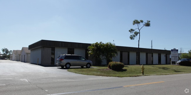
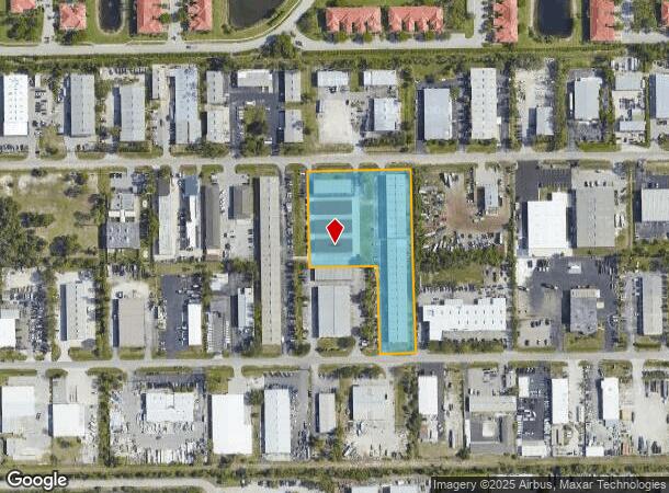
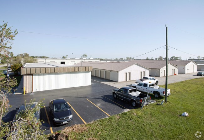
2159 Andrea Ln
25-45-24-00-00001.0410
S. 41 Corridor
Warehouse
PARL IN N 1/2 DESC OR 1337 PGS 1431+1426 LESS OR 1983/3954
AE
Lee
12071C0436H
Florida
2024
3.08 AC
2025
S Ft Myers/San Carlos
001602
Southwest Florida
50,812 SF
Cape Coral-Fort Myers, FL
DEMOGRAPHICS near 2159 Andrea Ln
1 Mile
3 Mile
5 Mile
2024 Total Population
4,039
56,619
131,498
2029 Population
4,746
66,898
155,909
Pop Growth 2024-2029
+ 17.50%
+ 18.15%
+ 18.56%
Average Age
56
50
48
2024 Total Households
2,195
27,261
60,432
HH Growth 2024-2029
+ 17.04%
+ 17.84%
+ 18.23%
Median Household Inc
$64,340
$60,839
$65,782
Avg Household Size
1.80
2.00
2.10
2024 Avg HH Vehicles
2.00
2.00
2.00
Median Home Value
$108,451
$247,554
$279,877
Median Year Built
1988
1987
1991
Nearby Places
- Restaurants
- Banks
- Shops
- Fitness
- Groceries
PUBLIC TRANSPORTATION
AIRPORT
Southwest Florida International
DRIVE
WALK
Distance
Southwest Florida International
18 min
8.9 mi
Punta Gorda
DRIVE
WALK
Distance
Punta Gorda
47 min
35.1 mi
Freight Ports
Port Manatee
DRIVE
WALK
Distance
Port Manatee
127 min
106.7 mi
SALE & LEASE HISTORY
LISTING DATE
SALE/LEASE

Nov 22, 2023
For Lease
Aug 22, 2019
For Lease
Nearby Properties
Address
Land Use
TOTAL SIZE
Lot Size
Zoning
Address
Land Use
TOTAL SIZE
Lot Size
Zoning
741,488 SF
23.22 AC
CPD
Address
Land Use
TOTAL SIZE
Lot Size
Zoning
1,001,577 SF
140.54 AC
AG-2
Address
Land Use
TOTAL SIZE
Lot Size
Zoning
541,926 SF
54.06 AC
RM2
Address
Land Use
TOTAL SIZE
Lot Size
Zoning
539,207 SF
61.09 AC
AG-2
Address
Land Use
TOTAL SIZE
Lot Size
Zoning
576,858 SF
77.73 AC
CF-2
Address
Land Use
TOTAL SIZE
Lot Size
Zoning
562,104 SF
18.98 AC
RPD
Address
Land Use
TOTAL SIZE
Lot Size
Zoning
15.08 AC
Address
Land Use
TOTAL SIZE
Lot Size
Zoning
331,738 SF
39.51 AC
RM-10
Address
Land Use
TOTAL SIZE
Lot Size
Zoning
445,073 SF
44.82 AC
C-1
Address
Land Use
TOTAL SIZE
Lot Size
Zoning
346,817 SF
26.28 AC
MPD
Address
Land Use
TOTAL SIZE
Lot Size
Zoning
25.16 AC
RPD
Address
Land Use
TOTAL SIZE
Lot Size
Zoning
441,655 SF
33.09 AC
RM-2
Address
Land Use
TOTAL SIZE
Lot Size
Zoning
347,746 SF
29.74 AC
RM-10
Address
Land Use
TOTAL SIZE
Lot Size
Zoning
444,774 SF
36.07 AC
MPD
Address
Land Use
TOTAL SIZE
Lot Size
Zoning
381,135 SF
15.07 AC
MPD
Address
Land Use
TOTAL SIZE
Lot Size
Zoning
313,327 SF
29.72 AC
C-1
Address
Land Use
TOTAL SIZE
Lot Size
Zoning
1,446 SF
9.81 AC
RS-6
Address
Land Use
TOTAL SIZE
Lot Size
Zoning
59,832 SF
4.23 AC
CPD
Address
Land Use
TOTAL SIZE
Lot Size
Zoning
261,136 SF
11.68 AC
AG-2
Address
Land Use
TOTAL SIZE
Lot Size
Zoning
9,670 SF
9.12 AC
AG-2
Address
Land Use
TOTAL SIZE
Lot Size
Zoning
206,290 SF
31.37 AC
CFPD
Address
Land Use
TOTAL SIZE
Lot Size
Zoning
170,495 SF
7.80 AC
CPD
Address
Land Use
TOTAL SIZE
Lot Size
Zoning
127,625 SF
11.45 AC
CPD
Address
Land Use
TOTAL SIZE
Lot Size
Zoning
116,776 SF
9.06 AC
CPD
Address
Land Use
TOTAL SIZE
Lot Size
Zoning
137,556 SF
4.73 AC
C-1
Address
Land Use
TOTAL SIZE
Lot Size
Zoning
316,597 SF
19.19 AC
IPD
Address
Land Use
TOTAL SIZE
Lot Size
Zoning
7.06 AC
MPD
Address
Land Use
TOTAL SIZE
Lot Size
Zoning
406,192 SF
2.75 AC
CPD
Address
Land Use
TOTAL SIZE
Lot Size
Zoning
112,487 SF
4.75 AC
C-1
Address
Land Use
TOTAL SIZE
Lot Size
Zoning
2.54 AC
MPD
The World's #1 Commercial Real Estate Marketplace
Connect with us
© 2025 CoStar Group
The information above has been obtained from sources believed reliable. While we do not doubt its accuracy we have not verified it and make no guarantee, warranty or representation about it. It is your responsibility to independently confirm its accuracy and completeness. Any projections, opinions, assumptions, or estimates used are for example only and do not represent the current or future performance of the property. The value of this transaction to you depends on tax and other factors which should be evaluated by your tax, financial, and legal advisors. You and your advisors should conduct a careful, independent investigation of the property to determine to your satisfaction the suitability of the property for your needs.