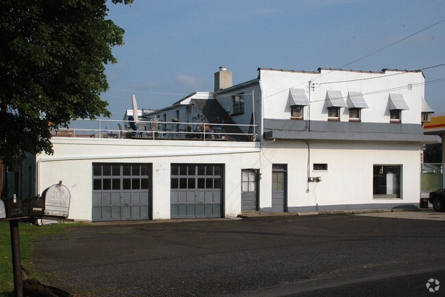
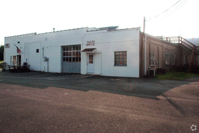
Property Record
2301 N 5Th St, Perkasie, PA 18944

NEARBY LISTINGS FOR SALE OR LEASE
-
-
View all Perkasie listings for sale on LoopNet.com
Property Detail
2301 N 5Th St
12-015-001
LOT .811AC ES OF SR313 380FT E SR313
Autorepair
Bucks
X
Pennsylvania
42017C0144J
811ac
2024
6.60 AC
2025
Upper Bucks County
102102
Philadelphia
24,929 SF
Philadelphia-Camden-Wilmington, PA-NJ-DE-MD
DEMOGRAPHICS near 2301 N 5Th St
1 Mile
3 Mile
5 Mile
2024 Total Population
827
13,419
49,467
2029 Population
818
13,430
49,354
Pop Growth 2024-2029
(1.09%)
+ 0.08%
(0.23%)
Average Age
45
43
42
2024 Total Households
323
5,201
18,715
HH Growth 2024-2029
(1.24%)
+ 0.15%
(0.24%)
Median Household Inc
$99,999
$106,491
$101,189
Avg Household Size
2.50
2.60
2.60
2024 Avg HH Vehicles
2.00
2.00
2.00
Median Home Value
$438,775
$381,641
$369,855
Median Year Built
1963
1975
1979
Nearby Places
Map Layers
Map Styles
 Street
 Aerial
- Restaurants
- Banks
- Shops
- Fitness
- Groceries
PUBLIC TRANSPORTATION
AIRPORT
Lehigh Valley International
DRIVE
WALK
Distance
Lehigh Valley International
45 min
25.3 mi
Trenton Mercer
DRIVE
WALK
Distance
Trenton Mercer
51 min
30.7 mi
Freight Ports
Port of Philadelphia
DRIVE
WALK
Distance
Port of Philadelphia
60 min
36.3 mi
Nearby Properties
Address
Land Use
TOTAL SIZE
Lot Size
Zoning
Address
Land Use
TOTAL SIZE
Lot Size
Zoning
61,589 SF
10.81 AC
C2
Address
Land Use
TOTAL SIZE
Lot Size
Zoning
63,433 SF
8.20 AC
CO
Address
Land Use
TOTAL SIZE
Lot Size
Zoning
105,840 SF
2.42 AC
R1B
Address
Land Use
TOTAL SIZE
Lot Size
Zoning
101,920 SF
21.05 AC
R1B
Address
Land Use
TOTAL SIZE
Lot Size
Zoning
12,000 SF
128.21 AC
I1
Address
Land Use
TOTAL SIZE
Lot Size
Zoning
9,680 SF
57.74 AC
Q
Address
Land Use
TOTAL SIZE
Lot Size
Zoning
5,525 SF
2.57 AC
PC2
Address
Land Use
TOTAL SIZE
Lot Size
Zoning
17,641 SF
12.71 AC
RP
Address
Land Use
TOTAL SIZE
Lot Size
Zoning
12,788 SF
1.88 AC
C1
Address
Land Use
TOTAL SIZE
Lot Size
Zoning
6,810 SF
0.35 AC
R2
Address
Land Use
TOTAL SIZE
Lot Size
Zoning
12,859 SF
2.19 AC
PC2
Address
Land Use
TOTAL SIZE
Lot Size
Zoning
42,360 SF
4.42 AC
PC2
Address
Land Use
TOTAL SIZE
Lot Size
Zoning
0.17 AC
I2
Address
Land Use
TOTAL SIZE
Lot Size
Zoning
6 AC
I1
Address
Land Use
TOTAL SIZE
Lot Size
Zoning
6,015 SF
1.03 AC
C1
Address
Land Use
TOTAL SIZE
Lot Size
Zoning
10,000 SF
3.20 AC
PC2
Address
Land Use
TOTAL SIZE
Lot Size
Zoning
7,360 SF
1.06 AC
C1
Address
Land Use
TOTAL SIZE
Lot Size
Zoning
22,172 SF
6.25 AC
RA
Address
Land Use
TOTAL SIZE
Lot Size
Zoning
2,840 SF
0.82 AC
C1
Address
Land Use
TOTAL SIZE
Lot Size
Zoning
10,695 SF
0.14 AC
C2
Address
Land Use
TOTAL SIZE
Lot Size
Zoning
23,802 SF
3 AC
I1
Address
Land Use
TOTAL SIZE
Lot Size
Zoning
8,685 SF
1.33 AC
RA
Address
Land Use
TOTAL SIZE
Lot Size
Zoning
46.48 AC
I
Address
Land Use
TOTAL SIZE
Lot Size
Zoning
2,450 SF
221.59 AC
E
Address
Land Use
TOTAL SIZE
Lot Size
Zoning
9,600 SF
2.34 AC
PC2
Address
Land Use
TOTAL SIZE
Lot Size
Zoning
3,232 SF
1.01 AC
CO
Address
Land Use
TOTAL SIZE
Lot Size
Zoning
1,248 SF
0.93 AC
R1
Address
Land Use
TOTAL SIZE
Lot Size
Zoning
6,852 SF
3.53 AC
S
Address
Land Use
TOTAL SIZE
Lot Size
Zoning
1,717 SF
2 AC
PC2
The World's #1 Commercial Real Estate Marketplace
Connect with us
© 2025 CoStar Group
The information above has been obtained from sources believed reliable. While we do not doubt its accuracy we have not verified it and make no guarantee, warranty or representation about it. It is your responsibility to independently confirm its accuracy and completeness. Any projections, opinions, assumptions, or estimates used are for example only and do not represent the current or future performance of the property. The value of this transaction to you depends on tax and other factors which should be evaluated by your tax, financial, and legal advisors. You and your advisors should conduct a careful, independent investigation of the property to determine to your satisfaction the suitability of the property for your needs.