Property Record
2301 W River Rd, Dayton, OH 45417


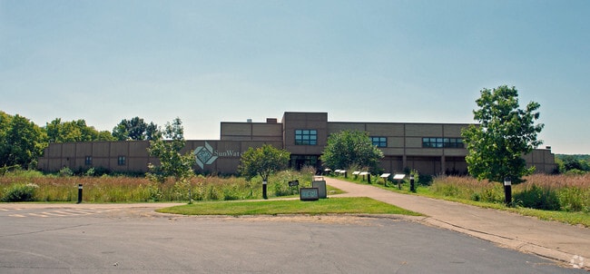
Property Detail
2301 W River Rd
Dayton, OH
75816 & PT VAC ST
R72-16908-0009
Montgomery
Municipalproperty
Ohio
AE The base floodplain where base flood elevations are provided. AE Zones are now used on new format FIRMs instead of A1-A30 Zones.
9
2024
25.72 AC
2025
South Central Dayton
004300
Cincinnati/Dayton
118,234 SF
NEARBY LISTINGS FOR SALE OR LEASE
DEMOGRAPHICS near 2301 W River Rd
1 mile
3 mile
5 mile
2025 Total Population
1,001
42,581
186,328
2030 Population
1,023
43,456
189,987
Pop Growth 2025-2030
+ 2.20%
+ 2.05%
+ 1.96%
Average Age
38
39
39
2025 Total Households
395
17,767
79,457
HH Growth 2025-2030
+ 2.28%
+ 2.16%
+ 1.99%
Median Household Inc
$51,053
$45,861
$54,695
Avg Household Size
2.40
2.20
2.20
2025 Avg HH Vehicles
2.00
2.00
2.00
Median Home Value
$152,469
$135,422
$162,534
Median Year Built
1959
1957
1956
Nearby Places
Map Layers
Map Styles
 Street
 Aerial
Layers
 Traffic
 Biking
Places
Listings with unknown addresses are not visible on the map
- Restaurants
- Banks
- Shops
- Fitness
- Groceries
PUBLIC TRANSPORTATION
AIRPORT
James M Cox Dayton International
Drive
Walk
Distance
James M Cox Dayton International
28 min
16.9 mi
Freight Ports
Port of Toledo
Drive
Walk
Distance
Port of Toledo
185 min
157.0 mi
Nearby Properties
Address
Land Use
TOTAL SIZE
Lot Size
Zoning
Address
Land Use
TOTAL SIZE
Lot Size
Zoning
428,925 SF
21.70 AC
Address
Land Use
TOTAL SIZE
Lot Size
Zoning
134,515 SF
370.05 AC
Address
Land Use
TOTAL SIZE
Lot Size
Zoning
104,705 SF
36.80 AC
Address
Land Use
TOTAL SIZE
Lot Size
Zoning
640,970 SF
94.06 AC
Address
Land Use
TOTAL SIZE
Lot Size
Zoning
125,433 SF
92.08 AC
Address
Land Use
TOTAL SIZE
Lot Size
Zoning
17,478 SF
417.01 AC
Address
Land Use
TOTAL SIZE
Lot Size
Zoning
23,031 SF
63.14 AC
Address
Land Use
TOTAL SIZE
Lot Size
Zoning
5.41 AC
Address
Land Use
TOTAL SIZE
Lot Size
Zoning
11.83 AC
Address
Land Use
TOTAL SIZE
Lot Size
Zoning
45,583 SF
4.91 AC
Address
Land Use
TOTAL SIZE
Lot Size
Zoning
3.27 AC
Address
Land Use
TOTAL SIZE
Lot Size
Zoning
128,859 SF
5.31 AC
Address
Land Use
TOTAL SIZE
Lot Size
Zoning
88,479 SF
4.43 AC
Address
Land Use
TOTAL SIZE
Lot Size
Zoning
69,939 SF
90.27 AC
Address
Land Use
TOTAL SIZE
Lot Size
Zoning
254,552 SF
9.83 AC
Address
Land Use
TOTAL SIZE
Lot Size
Zoning
128,246 SF
3.82 AC
Address
Land Use
TOTAL SIZE
Lot Size
Zoning
54.85 AC
Address
Land Use
TOTAL SIZE
Lot Size
Zoning
414,124 SF
14.98 AC
Address
Land Use
TOTAL SIZE
Lot Size
Zoning
94,027 SF
7.99 AC
Address
Land Use
TOTAL SIZE
Lot Size
Zoning
330,404 SF
68.13 AC
Address
Land Use
TOTAL SIZE
Lot Size
Zoning
600,884 SF
38.61 AC
Address
Land Use
TOTAL SIZE
Lot Size
Zoning
362,494 SF
17.03 AC
Address
Land Use
TOTAL SIZE
Lot Size
Zoning
8.82 AC
Address
Land Use
TOTAL SIZE
Lot Size
Zoning
439,169 SF
16 AC
Address
Land Use
TOTAL SIZE
Lot Size
Zoning
92,512 SF
9.24 AC
Address
Land Use
TOTAL SIZE
Lot Size
Zoning
121,875 SF
8.21 AC
Address
Land Use
TOTAL SIZE
Lot Size
Zoning
44,800 SF
29.95 AC
Address
Land Use
TOTAL SIZE
Lot Size
Zoning
25.32 AC
Address
Land Use
TOTAL SIZE
Lot Size
Zoning
11.14 AC
The World's #1 Commercial Real Estate Marketplace
Connect with us
© 2026 CoStar Group
The information above has been obtained from sources believed reliable. While we do not doubt its accuracy we have not verified it and make no guarantee, warranty or representation about it. It is your responsibility to independently confirm its accuracy and completeness. Any projections, opinions, assumptions, or estimates used are for example only and do not represent the current or future performance of the property. The value of this transaction to you depends on tax and other factors which should be evaluated by your tax, financial, and legal advisors. You and your advisors should conduct a careful, independent investigation of the property to determine to your satisfaction the suitability of the property for your needs.