Property Record
23015 Pine St, Newhall, CA 91321


Save to a Folder
{{folder.Name}}
{{folder.ListingIds.length}} Properties
{{folder.ListingIds.length}} Property
Create a New Folder
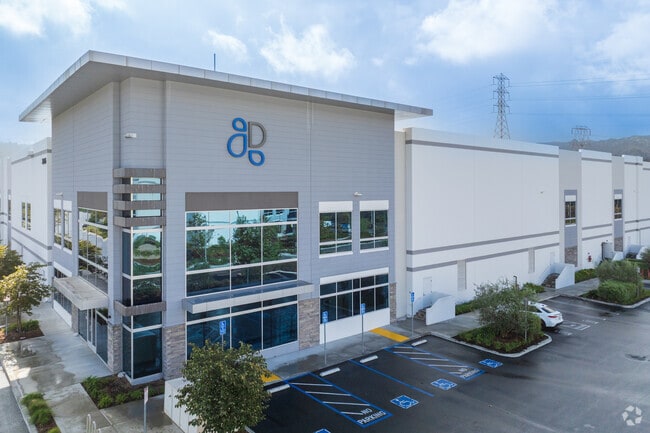
Property Detail
23015 Pine St
2827-053-004
TR=50283-02 LOT 2
Warehouse
LOS ANGELES
SCBP
California
B and X Area of moderate flood hazard, usually the area between the limits of the 100-year and 500-year floods.
2
2025
9.18 AC
2025
Santa Clarita Valley
920312
Los Angeles
187,990 SF
Los Angeles-Long Beach-Glendale, CA
NEARBY LISTINGS FOR SALE OR LEASE
-
-
View all Newhall listings for lease on LoopNet.com
DEMOGRAPHICS near 23015 Pine St
1 mile
3 mile
5 mile
2025 Total Population
2,623
30,292
144,434
2030 Population
2,653
29,968
143,198
Pop Growth 2025-2030
+ 1.14%
(1.07%)
(0.86%)
Average Age
36
39
41
2025 Total Households
776
9,404
47,396
HH Growth 2025-2030
+ 0.90%
(1.45%)
(1.05%)
Median Household Inc
$82,800
$100,806
$111,484
Avg Household Size
3.20
3.10
2.90
2025 Avg HH Vehicles
2.00
2.00
2.00
Median Home Value
$603,896
$775,247
$766,103
Median Year Built
1982
1979
1983
Nearby Places
Map Layers
Map Styles
 Street
 Aerial
Layers
 Traffic
 Biking
Places
Listings with unknown addresses are not visible on the map
- Restaurants
- Banks
- Shops
- Fitness
- Groceries
PUBLIC TRANSPORTATION
COMMUTER RAIL
Newhall (Antelope Valley Line - Southern California Regional Rail Authority (Metrolink))
Drive
Walk
Distance
Newhall (Antelope Valley Line - Southern California Regional Rail Authority (Metrolink))
7 min
2.9 mi
Santa Clarita (Antelope Valley Line - Southern California Regional Rail Authority (Metrolink))
Drive
Walk
Distance
Santa Clarita (Antelope Valley Line - Southern California Regional Rail Authority (Metrolink))
14 min
7.2 mi
AIRPORT
Bob Hope
Drive
Walk
Distance
Bob Hope
24 min
17.0 mi
Los Angeles International
Drive
Walk
Distance
Los Angeles International
45 min
34.1 mi
Freight Ports
The Port of Hueneme
Drive
Walk
Distance
The Port of Hueneme
76 min
52.4 mi
SALE & LEASE HISTORY
LISTING DATE
SALE/LEASE

Jan 29, 2019
For Lease
Nearby Properties
Address
Land Use
TOTAL SIZE
Lot Size
Zoning
Address
Land Use
TOTAL SIZE
Lot Size
Zoning
143,163 SF
10.48 AC
SCUR3
Address
Land Use
TOTAL SIZE
Lot Size
Zoning
219,340 SF
12.77 AC
LAR3
Address
Land Use
TOTAL SIZE
Lot Size
Zoning
137,361 SF
7.38 AC
SCUR3
Address
Land Use
TOTAL SIZE
Lot Size
Zoning
220,738 SF
10.27 AC
LAM1
Address
Land Use
TOTAL SIZE
Lot Size
Zoning
144,152 SF
2.39 AC
LCA22-A21*
Address
Land Use
TOTAL SIZE
Lot Size
Zoning
180,584 SF
6.35 AC
SCUR3
Address
Land Use
TOTAL SIZE
Lot Size
Zoning
209,119 SF
3.24 AC
SCBP
Address
Land Use
TOTAL SIZE
Lot Size
Zoning
169,585 SF
9.16 AC
SCBP
Address
Land Use
TOTAL SIZE
Lot Size
Zoning
108,804 SF
2.39 AC
LAC2
Address
Land Use
TOTAL SIZE
Lot Size
Zoning
115,163 SF
7.15 AC
LAM1
Address
Land Use
TOTAL SIZE
Lot Size
Zoning
75,251 SF
1.71 AC
SCUR3
Address
Land Use
TOTAL SIZE
Lot Size
Zoning
57,232 SF
0.27 AC
SCSP
Address
Land Use
TOTAL SIZE
Lot Size
Zoning
135,228 SF
7.80 AC
SCUR3
Address
Land Use
TOTAL SIZE
Lot Size
Zoning
42,767 SF
0.26 AC
SCSP
Address
Land Use
TOTAL SIZE
Lot Size
Zoning
33,578 SF
SCCP
Address
Land Use
TOTAL SIZE
Lot Size
Zoning
188,057 SF
2.70 AC
SCCP
Address
Land Use
TOTAL SIZE
Lot Size
Zoning
92,596 SF
4.59 AC
LAM1
Address
Land Use
TOTAL SIZE
Lot Size
Zoning
48,867 SF
1.26 AC
SCUR2
Address
Land Use
TOTAL SIZE
Lot Size
Zoning
68,670 SF
3.22 AC
LAM1
Address
Land Use
TOTAL SIZE
Lot Size
Zoning
85,418 SF
6.05 AC
LAM1
Address
Land Use
TOTAL SIZE
Lot Size
Zoning
110,126 SF
6.31 AC
SCBP
Address
Land Use
TOTAL SIZE
Lot Size
Zoning
125,282 SF
8.17 AC
SCPI
Address
Land Use
TOTAL SIZE
Lot Size
Zoning
41,192 SF
3.01 AC
SCSP
Address
Land Use
TOTAL SIZE
Lot Size
Zoning
40,000 SF
3.61 AC
SCCP
Address
Land Use
TOTAL SIZE
Lot Size
Zoning
97,613 SF
4.21 AC
SCBP
Address
Land Use
TOTAL SIZE
Lot Size
Zoning
83,136 SF
4.73 AC
SCUR3
Address
Land Use
TOTAL SIZE
Lot Size
Zoning
108,362 SF
2.80 AC
LAM1
The World's #1 Commercial Real Estate Marketplace
Connect with us
© 2026 CoStar Group
The information above has been obtained from sources believed reliable. While we do not doubt its accuracy we have not verified it and make no guarantee, warranty or representation about it. It is your responsibility to independently confirm its accuracy and completeness. Any projections, opinions, assumptions, or estimates used are for example only and do not represent the current or future performance of the property. The value of this transaction to you depends on tax and other factors which should be evaluated by your tax, financial, and legal advisors. You and your advisors should conduct a careful, independent investigation of the property to determine to your satisfaction the suitability of the property for your needs.