Property Record
231 Redbud Ln, New Braunfels, TX 78130


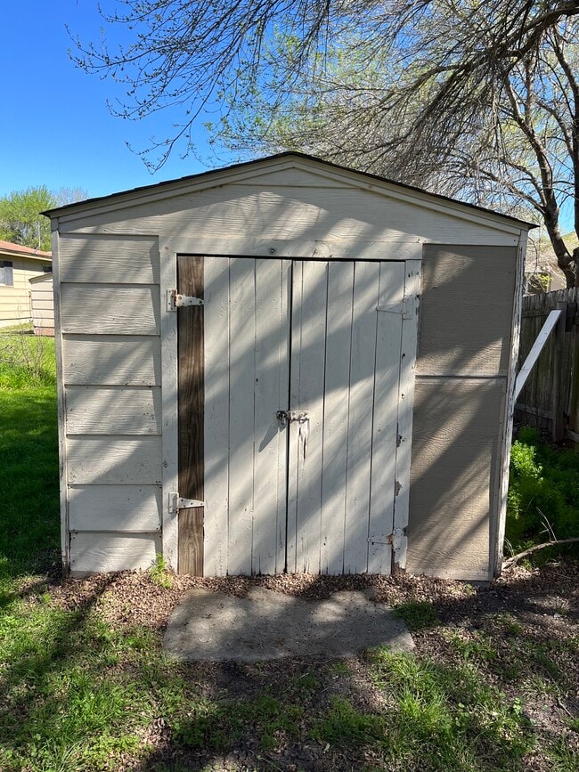
Property Detail
231 Redbud Ln
San Antonio-New Braunfels, TX
SHADOW PARK, BLOCK 2, LOT 8
50-0684-0017-00
Comal
Commercialnec
Texas
C and X Area of minimal flood hazard, usually depicted on FIRMs as above the 500-year flood level.
8
2024
0.20 AC
2025
Comal County
310404
San Antonio
1,632 SF
NEARBY LISTINGS FOR SALE OR LEASE
DEMOGRAPHICS near 231 Redbud Ln
1 mile
3 mile
5 mile
2025 Total Population
10,443
72,903
119,160
2030 Population
11,975
83,929
138,230
Pop Growth 2025-2030
+ 14.67%
+ 15.12%
+ 16.00%
Average Age
39
38
38
2025 Total Households
3,934
27,215
45,032
HH Growth 2025-2030
+ 15.05%
+ 15.56%
+ 16.41%
Median Household Inc
$93,535
$88,798
$90,109
Avg Household Size
2.60
2.60
2.60
2025 Avg HH Vehicles
2.00
2.00
2.00
Median Home Value
$318,259
$334,339
$355,320
Median Year Built
1992
2000
2006
Nearby Places
Map Layers
Map Styles
 Street
 Aerial
Layers
 Traffic
 Biking
Places
Listings with unknown addresses are not visible on the map
- Restaurants
- Banks
- Shops
- Fitness
- Groceries
PUBLIC TRANSPORTATION
AIRPORT
San Antonio International
Drive
Walk
Distance
San Antonio International
35 min
27.4 mi
SALE & LEASE HISTORY
LISTING DATE
SALE/LEASE

Sep 30, 2024
For Lease
Feb 28, 2024
For Sale
Nearby Properties
Address
Land Use
TOTAL SIZE
Lot Size
Zoning
Address
Land Use
TOTAL SIZE
Lot Size
Zoning
111.44 AC
Address
Land Use
TOTAL SIZE
Lot Size
Zoning
350,595 SF
21.78 AC
Address
Land Use
TOTAL SIZE
Lot Size
Zoning
234,823 SF
72.17 AC
Address
Land Use
TOTAL SIZE
Lot Size
Zoning
248,377 SF
23.66 AC
Address
Land Use
TOTAL SIZE
Lot Size
Zoning
381,528 SF
82.50 AC
Address
Land Use
TOTAL SIZE
Lot Size
Zoning
170,266 SF
16.78 AC
Address
Land Use
TOTAL SIZE
Lot Size
Zoning
269,288 SF
16.32 AC
Address
Land Use
TOTAL SIZE
Lot Size
Zoning
103,782 SF
105.82 AC
Address
Land Use
TOTAL SIZE
Lot Size
Zoning
186,838 SF
14.53 AC
Address
Land Use
TOTAL SIZE
Lot Size
Zoning
135,975 SF
39.25 AC
Address
Land Use
TOTAL SIZE
Lot Size
Zoning
145,856 SF
9.52 AC
Address
Land Use
TOTAL SIZE
Lot Size
Zoning
152,240 SF
14.13 AC
Address
Land Use
TOTAL SIZE
Lot Size
Zoning
397,600 SF
25.95 AC
Address
Land Use
TOTAL SIZE
Lot Size
Zoning
170,019 SF
4.46 AC
Address
Land Use
TOTAL SIZE
Lot Size
Zoning
188,600 SF
4.61 AC
Address
Land Use
TOTAL SIZE
Lot Size
Zoning
132,319 SF
8.80 AC
Address
Land Use
TOTAL SIZE
Lot Size
Zoning
97,200 SF
12.87 AC
Address
Land Use
TOTAL SIZE
Lot Size
Zoning
180,795 SF
8.29 AC
Address
Land Use
TOTAL SIZE
Lot Size
Zoning
198,793 SF
9.38 AC
Address
Land Use
TOTAL SIZE
Lot Size
Zoning
191,652 SF
19.03 AC
Address
Land Use
TOTAL SIZE
Lot Size
Zoning
76,180 SF
5.74 AC
Address
Land Use
TOTAL SIZE
Lot Size
Zoning
61,079 SF
2.53 AC
Address
Land Use
TOTAL SIZE
Lot Size
Zoning
130,210 SF
13.57 AC
Address
Land Use
TOTAL SIZE
Lot Size
Zoning
205,071 SF
23.66 AC
Address
Land Use
TOTAL SIZE
Lot Size
Zoning
44.42 AC
Address
Land Use
TOTAL SIZE
Lot Size
Zoning
223,550 SF
11.80 AC
Address
Land Use
TOTAL SIZE
Lot Size
Zoning
122,247 SF
5.75 AC
Address
Land Use
TOTAL SIZE
Lot Size
Zoning
33,365 SF
13.90 AC
Address
Land Use
TOTAL SIZE
Lot Size
Zoning
66,336 SF
7.90 AC
Address
Land Use
TOTAL SIZE
Lot Size
Zoning
156,335 SF
9.94 AC
The World's #1 Commercial Real Estate Marketplace
Connect with us
© 2026 CoStar Group
The information above has been obtained from sources believed reliable. While we do not doubt its accuracy we have not verified it and make no guarantee, warranty or representation about it. It is your responsibility to independently confirm its accuracy and completeness. Any projections, opinions, assumptions, or estimates used are for example only and do not represent the current or future performance of the property. The value of this transaction to you depends on tax and other factors which should be evaluated by your tax, financial, and legal advisors. You and your advisors should conduct a careful, independent investigation of the property to determine to your satisfaction the suitability of the property for your needs.