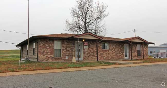
Property Record
2325 North St, Granite City, IL 62040


Save to a Folder
{{folder.Name}}
{{folder.ListingIds.length}} Properties
{{folder.ListingIds.length}} Property
Create a New Folder
Property Detail
2325 North St
St. Louis, MO-IL
PART PARCEL 1
21-1-35-12-00-000-001
Madison
Manufacturinglight
Illinois
2025
5.29 AC
2025
Illinois
400200
St. Louis
108,360 SF
NEARBY LISTINGS FOR SALE OR LEASE
DEMOGRAPHICS near 2325 North St
1 mile
3 mile
5 mile
2025 Total Population
2,414
27,277
110,619
2030 Population
2,500
27,660
111,266
Pop Growth 2025-2030
+ 3.56%
+ 1.40%
+ 0.58%
Average Age
41
40
41
2025 Total Households
1,004
11,353
45,766
HH Growth 2025-2030
+ 3.59%
+ 1.26%
+ 0.36%
Median Household Inc
$36,777
$51,180
$47,302
Avg Household Size
2.30
2.30
2.30
2025 Avg HH Vehicles
2.00
2.00
1.00
Median Home Value
$53,536
$76,302
$83,315
Median Year Built
1954
1955
1955
Nearby Places
Map Layers
Map Styles
 Street
 Aerial
Layers
 Traffic
 Biking
Places
Listings with unknown addresses are not visible on the map
- Restaurants
- Banks
- Shops
- Fitness
- Groceries
PUBLIC TRANSPORTATION
COMMUTER RAIL
Arch-Laclede's Landing (Lambert Airport Shiloh-Scott - St. Louis MetroLink (MetroLink), Shrewsbury-Lansdowne I-44 Emerson Park - St. Louis MetroLink (MetroLink))
Drive
Walk
Distance
Arch-Laclede's Landing (Lambert Airport Shiloh-Scott - St. Louis MetroLink (MetroLink), Shrewsbury-Lansdowne I-44 Emerson Park - St. Louis MetroLink (MetroLink))
13 min
8.1 mi
East Riverfront (Lambert Airport Shiloh-Scott - St. Louis MetroLink (MetroLink), Shrewsbury-Lansdowne I-44 Emerson Park - St. Louis MetroLink (MetroLink))
Drive
Walk
Distance
East Riverfront (Lambert Airport Shiloh-Scott - St. Louis MetroLink (MetroLink), Shrewsbury-Lansdowne I-44 Emerson Park - St. Louis MetroLink (MetroLink))
14 min
8.6 mi
AIRPORT
St Louis Lambert International
Drive
Walk
Distance
St Louis Lambert International
27 min
17.1 mi
Scott AFB/Midamerica St Louis
Drive
Walk
Distance
Scott AFB/Midamerica St Louis
47 min
29.5 mi
Freight Ports
Port Milwaukee
Drive
Walk
Distance
Port Milwaukee
415 min
365.5 mi
Nearby Properties
Address
Land Use
TOTAL SIZE
Lot Size
Zoning
Address
Land Use
TOTAL SIZE
Lot Size
Zoning
33.55 AC
Address
Land Use
TOTAL SIZE
Lot Size
Zoning
Address
Land Use
TOTAL SIZE
Lot Size
Zoning
28.04 AC
Address
Land Use
TOTAL SIZE
Lot Size
Zoning
1,925 SF
79.42 AC
Address
Land Use
TOTAL SIZE
Lot Size
Zoning
3.46 AC
Address
Land Use
TOTAL SIZE
Lot Size
Zoning
3.26 AC
Address
Land Use
TOTAL SIZE
Lot Size
Zoning
71,730 SF
3.23 AC
Address
Land Use
TOTAL SIZE
Lot Size
Zoning
165.04 AC
Address
Land Use
TOTAL SIZE
Lot Size
Zoning
39.86 AC
A
Address
Land Use
TOTAL SIZE
Lot Size
Zoning
184,803 SF
19.16 AC
Address
Land Use
TOTAL SIZE
Lot Size
Zoning
4,000 SF
29.50 AC
Address
Land Use
TOTAL SIZE
Lot Size
Zoning
190.47 AC
Address
Land Use
TOTAL SIZE
Lot Size
Zoning
8,000 SF
16.53 AC
Address
Land Use
TOTAL SIZE
Lot Size
Zoning
6,240 SF
4.50 AC
Address
Land Use
TOTAL SIZE
Lot Size
Zoning
132,482 SF
19.31 AC
Address
Land Use
TOTAL SIZE
Lot Size
Zoning
240,069 SF
14.20 AC
Address
Land Use
TOTAL SIZE
Lot Size
Zoning
8,510 SF
27.51 AC
Address
Land Use
TOTAL SIZE
Lot Size
Zoning
11,541 SF
11.82 AC
Address
Land Use
TOTAL SIZE
Lot Size
Zoning
102,355 SF
9.31 AC
Address
Land Use
TOTAL SIZE
Lot Size
Zoning
3,806 SF
10.78 AC
Address
Land Use
TOTAL SIZE
Lot Size
Zoning
5,610 SF
50.66 AC
Address
Land Use
TOTAL SIZE
Lot Size
Zoning
14.02 AC
Address
Land Use
TOTAL SIZE
Lot Size
Zoning
444 SF
9.80 AC
Address
Land Use
TOTAL SIZE
Lot Size
Zoning
47,556 SF
1.62 AC
Address
Land Use
TOTAL SIZE
Lot Size
Zoning
21.20 AC
Address
Land Use
TOTAL SIZE
Lot Size
Zoning
13,300 SF
5.05 AC
Address
Land Use
TOTAL SIZE
Lot Size
Zoning
309,129 SF
29.47 AC
Address
Land Use
TOTAL SIZE
Lot Size
Zoning
69.24 AC
A
Address
Land Use
TOTAL SIZE
Lot Size
Zoning
92,130 SF
11.15 AC
Address
Land Use
TOTAL SIZE
Lot Size
Zoning
30,906 SF
1.68 AC
The World's #1 Commercial Real Estate Marketplace
Connect with us
© 2026 CoStar Group
The information above has been obtained from sources believed reliable. While we do not doubt its accuracy we have not verified it and make no guarantee, warranty or representation about it. It is your responsibility to independently confirm its accuracy and completeness. Any projections, opinions, assumptions, or estimates used are for example only and do not represent the current or future performance of the property. The value of this transaction to you depends on tax and other factors which should be evaluated by your tax, financial, and legal advisors. You and your advisors should conduct a careful, independent investigation of the property to determine to your satisfaction the suitability of the property for your needs.