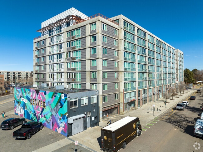
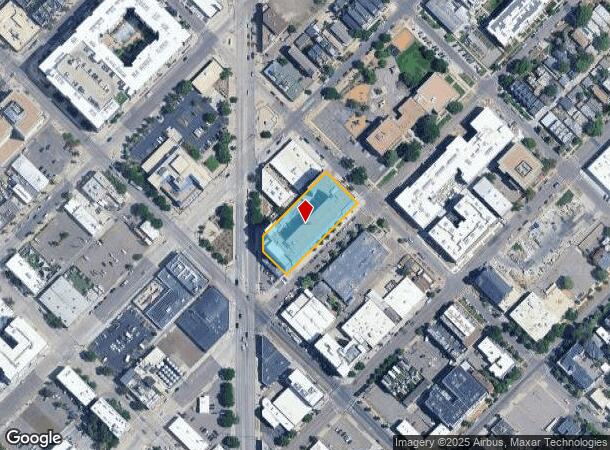
Property Record
2321 Arapahoe St, Denver, CO 80205
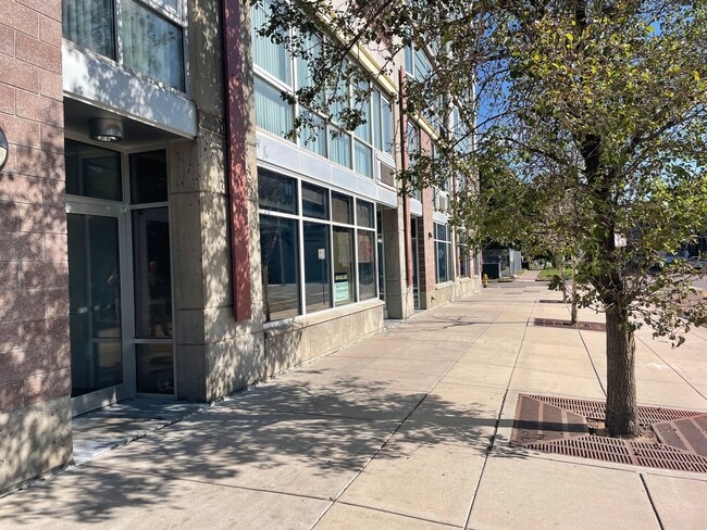
Current Lease Availabilities
NEARBY LISTINGS FOR SALE OR LEASE
Property Detail
2321 Arapahoe St
Denver
East Denver
Denver-Aurora-Lakewood, CO
DAVIS ADD EAST DENVER B83 PT OF L21 & L22 TO 32 AND THE SE 1/2 OF ALLEY VAC BY ORD 512 2003 AN UNDIVIDED 93% INT AND ALL RES IMPS THEREON FOR COMM SEE 02342-20-055-000
2342-20-054
Denver
Apartment
Colorado
0
21
2024
0.89 AC
002300
Five Points
145,201 SF
DEMOGRAPHICS near 2321 Arapahoe St
1 Mile
3 Mile
5 Mile
2024 Total Population
51,945
226,713
458,119
2029 Population
53,547
231,263
464,623
Pop Growth 2024-2029
+ 3.08%
+ 2.01%
+ 1.42%
Average Age
37
37
38
2024 Total Households
30,888
120,263
217,887
HH Growth 2024-2029
+ 3.23%
+ 2.02%
+ 1.48%
Median Household Inc
$92,092
$86,444
$84,639
Avg Household Size
1.60
1.80
2.00
2024 Avg HH Vehicles
1.00
1.00
1.00
Median Home Value
$731,909
$682,712
$650,899
Median Year Built
2007
1971
1966
Nearby Places
Map Layers
Map Styles
 Street
 Aerial
- Restaurants
- Banks
- Shops
- Fitness
- Groceries
PUBLIC TRANSPORTATION
TRANSIT/SUBWAY
25th-Welton (D Line - Denver Regional Transportation District Light Rail (TheRide))
DRIVE
WALK
Distance
25th-Welton (D Line - Denver Regional Transportation District Light Rail (TheRide))
2 min
10 min
0.5 mi
20th-Welton (D Line - Denver Regional Transportation District Light Rail (TheRide))
DRIVE
WALK
Distance
20th-Welton (D Line - Denver Regional Transportation District Light Rail (TheRide))
2 min
11 min
0.5 mi
18th-Stout (D Line - Denver Regional Transportation District Light Rail (TheRide), F Line - Denver Regional Transportation District Light Rail (TheRide), H Line - Denver Regional Transportation District Light Rail (TheRide))
DRIVE
WALK
Distance
18th-Stout (D Line - Denver Regional Transportation District Light Rail (TheRide), F Line - Denver Regional Transportation District Light Rail (TheRide), H Line - Denver Regional Transportation District Light Rail (TheRide))
3 min
12 min
0.6 mi
27th-Welton (D Line - Denver Regional Transportation District Light Rail (TheRide))
DRIVE
WALK
Distance
27th-Welton (D Line - Denver Regional Transportation District Light Rail (TheRide))
2 min
13 min
0.7 mi
18th-California (D Line - Denver Regional Transportation District Light Rail (TheRide), F Line - Denver Regional Transportation District Light Rail (TheRide), H Line - Denver Regional Transportation District Light Rail (TheRide))
DRIVE
WALK
Distance
18th-California (D Line - Denver Regional Transportation District Light Rail (TheRide), F Line - Denver Regional Transportation District Light Rail (TheRide), H Line - Denver Regional Transportation District Light Rail (TheRide))
3 min
13 min
0.7 mi
COMMUTER RAIL
DRIVE
WALK
Distance
3 min
19 min
1.0 mi
Union Station: LoDo-Coors Field-16th Street Mall (C Line - Denver Regional Transportation District Light Rail (TheRide), E Line - Denver Regional Transportation District Light Rail (TheRide), W Line - Denver Regional Transportation District Light Rail (TheRide))
DRIVE
WALK
Distance
Union Station: LoDo-Coors Field-16th Street Mall (C Line - Denver Regional Transportation District Light Rail (TheRide), E Line - Denver Regional Transportation District Light Rail (TheRide), W Line - Denver Regional Transportation District Light Rail (TheRide))
4 min
1.3 mi
AIRPORT
Denver International
DRIVE
WALK
Distance
Denver International
33 min
23.2 mi
Nearby Properties
Address
Land Use
TOTAL SIZE
Lot Size
Zoning
Address
Land Use
TOTAL SIZE
Lot Size
Zoning
1,882,179 SF
21.15 AC
D-TD
Address
Land Use
TOTAL SIZE
Lot Size
Zoning
1,721,086 SF
21.34 AC
C-MU-30
Address
Land Use
TOTAL SIZE
Lot Size
Zoning
857,233 SF
10.26 AC
CMP-H
Address
Land Use
TOTAL SIZE
Lot Size
Zoning
794,383 SF
0.90 AC
D-TD
Address
Land Use
TOTAL SIZE
Lot Size
Zoning
1,542,612 SF
1.56 AC
D-C
Address
Land Use
TOTAL SIZE
Lot Size
Zoning
1,567,575 SF
1.40 AC
D-C
Address
Land Use
TOTAL SIZE
Lot Size
Zoning
1,096,923 SF
16.14 AC
CMP-H
Address
Land Use
TOTAL SIZE
Lot Size
Zoning
1,312,939 SF
1.15 AC
D-C
Address
Land Use
TOTAL SIZE
Lot Size
Zoning
1,048,471 SF
2.44 AC
PUD
Address
Land Use
TOTAL SIZE
Lot Size
Zoning
545,292 SF
1.15 AC
D-C
Address
Land Use
TOTAL SIZE
Lot Size
Zoning
656,257 SF
3.05 AC
D-CV
Address
Land Use
TOTAL SIZE
Lot Size
Zoning
614,750 SF
0.23 AC
D-C
Address
Land Use
TOTAL SIZE
Lot Size
Zoning
611,828 SF
0.94 AC
PUD
Address
Land Use
TOTAL SIZE
Lot Size
Zoning
150,202 SF
13.24 AC
T-MU-30
Address
Land Use
TOTAL SIZE
Lot Size
Zoning
337,495 SF
0.57 AC
D-C
Address
Land Use
TOTAL SIZE
Lot Size
Zoning
858,528 SF
2.53 AC
D-C
Address
Land Use
TOTAL SIZE
Lot Size
Zoning
755,793 SF
2.44 AC
D-C
Address
Land Use
TOTAL SIZE
Lot Size
Zoning
677,832 SF
2.42 AC
D-C
Address
Land Use
TOTAL SIZE
Lot Size
Zoning
298,387 SF
0.88 AC
PUD
Address
Land Use
TOTAL SIZE
Lot Size
Zoning
724,981 SF
1.26 AC
D-C
Address
Land Use
TOTAL SIZE
Lot Size
Zoning
405,974 SF
1.78 AC
PUD
Address
Land Use
TOTAL SIZE
Lot Size
Zoning
1,018,386 SF
2.46 AC
D-C
Address
Land Use
TOTAL SIZE
Lot Size
Zoning
290,821 SF
1.16 AC
PUD
Address
Land Use
TOTAL SIZE
Lot Size
Zoning
604,358 SF
2.45 AC
D-C
Address
Land Use
TOTAL SIZE
Lot Size
Zoning
716,151 SF
2.45 AC
D-C
Address
Land Use
TOTAL SIZE
Lot Size
Zoning
618,768 SF
1.23 AC
D-C
Address
Land Use
TOTAL SIZE
Lot Size
Zoning
778,340 SF
0.61 AC
D-C
Address
Land Use
TOTAL SIZE
Lot Size
Zoning
334,746 SF
1.25 AC
D-LD
Address
Land Use
TOTAL SIZE
Lot Size
Zoning
764,724 SF
1 AC
D-C
Address
Land Use
TOTAL SIZE
Lot Size
Zoning
824,150 SF
1.95 AC
D-C
The World's #1 Commercial Real Estate Marketplace
Connect with us
© 2025 CoStar Group
The information above has been obtained from sources believed reliable. While we do not doubt its accuracy we have not verified it and make no guarantee, warranty or representation about it. It is your responsibility to independently confirm its accuracy and completeness. Any projections, opinions, assumptions, or estimates used are for example only and do not represent the current or future performance of the property. The value of this transaction to you depends on tax and other factors which should be evaluated by your tax, financial, and legal advisors. You and your advisors should conduct a careful, independent investigation of the property to determine to your satisfaction the suitability of the property for your needs.