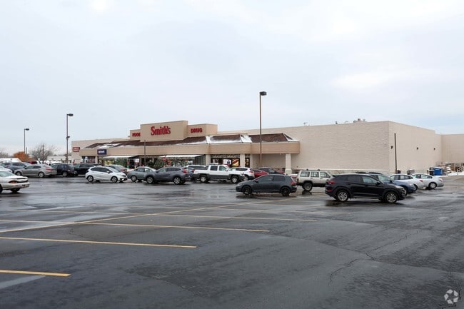
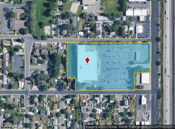
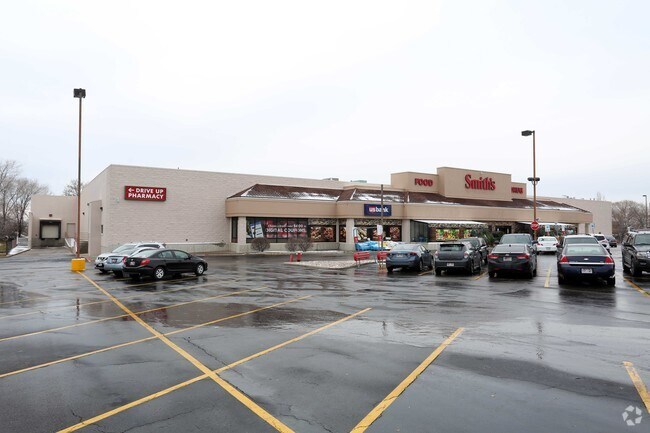
Property Record
2353 N Main St, Clearfield, UT 84015
NEARBY LISTINGS FOR SALE OR LEASE
Property Detail
2353 N Main St
13-069-0059
BEG AT A PT 185 FT W & 269.5 FT N FR SE COR SEC 23-T5N-R2W, SLM; TH W 643.8 FT; TH N 236.5 FT; TH E 643.8 FT; TH S 236.5 FT TO POB. CONT. 3.50 ACRES ALSO: BEG AT A PT W 378 FT, N 1 ROD FR SE COR O
Supermarket
Davis
X
Utah
49057C0425F
8.78 AC
2025
Davis/Weber Counties
2025
Salt Lake City
125301
Ogden-Clearfield, UT
72,653 SF
DEMOGRAPHICS near 2353 N Main St
1 Mile
3 Mile
5 Mile
2024 Total Population
9,999
90,870
218,093
2029 Population
10,518
96,761
233,240
Pop Growth 2024-2029
+ 5.19%
+ 6.48%
+ 6.95%
Average Age
35
34
34
2024 Total Households
3,306
29,145
70,611
HH Growth 2024-2029
+ 5.35%
+ 6.68%
+ 7.12%
Median Household Inc
$69,084
$74,787
$77,352
Avg Household Size
2.90
3.10
3.00
2024 Avg HH Vehicles
2.00
2.00
2.00
Median Home Value
$308,512
$341,670
$363,057
Median Year Built
1971
1986
1992
Nearby Places
Map Layers
Map Styles
 Street
 Aerial
- Restaurants
- Banks
- Shops
- Fitness
- Groceries
PUBLIC TRANSPORTATION
COMMUTER RAIL
Roy (FrontRunner North - Utah Transit Authority (UTA))
DRIVE
WALK
Distance
Roy (FrontRunner North - Utah Transit Authority (UTA))
8 min
3.8 mi
Clearfield (FrontRunner North - Utah Transit Authority (UTA))
DRIVE
WALK
Distance
Clearfield (FrontRunner North - Utah Transit Authority (UTA))
9 min
4.2 mi
AIRPORT
Salt Lake City International
DRIVE
WALK
Distance
Salt Lake City International
41 min
32.9 mi
Nearby Properties
Address
Land Use
TOTAL SIZE
Lot Size
Zoning
Address
Land Use
TOTAL SIZE
Lot Size
Zoning
664,440 SF
37.07 AC
Address
Land Use
TOTAL SIZE
Lot Size
Zoning
35,219 SF
58.98 AC
Address
Land Use
TOTAL SIZE
Lot Size
Zoning
125,164 SF
7.12 AC
Address
Land Use
TOTAL SIZE
Lot Size
Zoning
7,492 SF
8.96 AC
Address
Land Use
TOTAL SIZE
Lot Size
Zoning
71,940 SF
11 AC
Address
Land Use
TOTAL SIZE
Lot Size
Zoning
91,750 SF
6.76 AC
C2
Address
Land Use
TOTAL SIZE
Lot Size
Zoning
63,828 SF
5.30 AC
PF
Address
Land Use
TOTAL SIZE
Lot Size
Zoning
115,094 SF
13.88 AC
Address
Land Use
TOTAL SIZE
Lot Size
Zoning
76,778 SF
5.51 AC
Address
Land Use
TOTAL SIZE
Lot Size
Zoning
74,995 SF
6.07 AC
Address
Land Use
TOTAL SIZE
Lot Size
Zoning
225,497 SF
20.33 AC
Address
Land Use
TOTAL SIZE
Lot Size
Zoning
223,079 SF
22.55 AC
Address
Land Use
TOTAL SIZE
Lot Size
Zoning
147,184 SF
2.53 AC
Address
Land Use
TOTAL SIZE
Lot Size
Zoning
139,574 SF
9.30 AC
Address
Land Use
TOTAL SIZE
Lot Size
Zoning
11,877 SF
5.44 AC
CC
Address
Land Use
TOTAL SIZE
Lot Size
Zoning
121,173 SF
11.74 AC
CC
Address
Land Use
TOTAL SIZE
Lot Size
Zoning
62,246 SF
5.37 AC
PZ
Address
Land Use
TOTAL SIZE
Lot Size
Zoning
21,980 SF
11.68 AC
Address
Land Use
TOTAL SIZE
Lot Size
Zoning
140,015 SF
12.14 AC
PZ
Address
Land Use
TOTAL SIZE
Lot Size
Zoning
121,026 SF
4.78 AC
Address
Land Use
TOTAL SIZE
Lot Size
Zoning
13,590 SF
2.85 AC
Address
Land Use
TOTAL SIZE
Lot Size
Zoning
18,238 SF
2.74 AC
Address
Land Use
TOTAL SIZE
Lot Size
Zoning
88,125 SF
7.17 AC
PZ
Address
Land Use
TOTAL SIZE
Lot Size
Zoning
57,788 SF
5.24 AC
Address
Land Use
TOTAL SIZE
Lot Size
Zoning
58,287 SF
5.18 AC
Address
Land Use
TOTAL SIZE
Lot Size
Zoning
50,440 SF
5.26 AC
The World's #1 Commercial Real Estate Marketplace
Connect with us
© 2025 CoStar Group
The information above has been obtained from sources believed reliable. While we do not doubt its accuracy we have not verified it and make no guarantee, warranty or representation about it. It is your responsibility to independently confirm its accuracy and completeness. Any projections, opinions, assumptions, or estimates used are for example only and do not represent the current or future performance of the property. The value of this transaction to you depends on tax and other factors which should be evaluated by your tax, financial, and legal advisors. You and your advisors should conduct a careful, independent investigation of the property to determine to your satisfaction the suitability of the property for your needs.