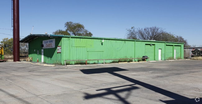
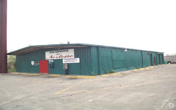
Property Record
2355 Highway 71 E, Del Valle, TX 78617


Property Detail
2355 Highway 71 E
Austin-Round Rock-San Marcos, TX
SW .388 AC OF LOT 1 NATIONAL MOBILE HOME PARKS SEC 1
291961
Travis
Autorepair
Texas
B and X Area of moderate flood hazard, usually the area between the limits of the 100-year and 500-year floods.
1
2025
0.39 AC
2025
Southeast
002310
Austin
5,000 SF
NEARBY LISTINGS FOR SALE OR LEASE
DEMOGRAPHICS near 2355 Highway 71 E
1 mile
3 mile
5 mile
2025 Total Population
2,404
26,602
130,329
2030 Population
2,539
28,577
138,465
Pop Growth 2025-2030
+ 5.62%
+ 7.42%
+ 6.24%
Average Age
34
35
35
2025 Total Households
706
9,143
52,557
HH Growth 2025-2030
+ 6.23%
+ 8.31%
+ 6.83%
Median Household Inc
$44,999
$79,707
$81,411
Avg Household Size
3.00
2.80
2.40
2025 Avg HH Vehicles
2.00
2.00
2.00
Median Home Value
$89,830
$361,760
$433,313
Median Year Built
1992
2009
2003
Nearby Places
Map Layers
Map Styles
 Street
 Aerial
Transit
 Traffic
 Biking
Places
Listings with unknown addresses are not visible on the map
- Restaurants
- Banks
- Shops
- Fitness
- Groceries
PUBLIC TRANSPORTATION
COMMUTER RAIL
Austin (Texas Eagle - Amtrak)
Drive
Walk
Distance
Austin (Texas Eagle - Amtrak)
14 min
7.8 mi
AIRPORT
Austin-Bergstrom International
Drive
Walk
Distance
Austin-Bergstrom International
16 min
7.7 mi
Freight Ports
Calhoun Port
Drive
Walk
Distance
Calhoun Port
179 min
151.8 mi
Nearby Properties
Address
Land Use
TOTAL SIZE
Lot Size
Zoning
Address
Land Use
TOTAL SIZE
Lot Size
Zoning
9,768 SF
386.80 AC
Address
Land Use
TOTAL SIZE
Lot Size
Zoning
942.08 AC
Address
Land Use
TOTAL SIZE
Lot Size
Zoning
307,610 SF
8.95 AC
Address
Land Use
TOTAL SIZE
Lot Size
Zoning
255,483 SF
35 AC
Address
Land Use
TOTAL SIZE
Lot Size
Zoning
354,664 SF
16.80 AC
Address
Land Use
TOTAL SIZE
Lot Size
Zoning
193,788 SF
107.16 AC
Address
Land Use
TOTAL SIZE
Lot Size
Zoning
206,608 SF
10.61 AC
Address
Land Use
TOTAL SIZE
Lot Size
Zoning
278,730 SF
19.78 AC
Address
Land Use
TOTAL SIZE
Lot Size
Zoning
262,576 SF
15.68 AC
Address
Land Use
TOTAL SIZE
Lot Size
Zoning
179,800 SF
442.94 AC
Address
Land Use
TOTAL SIZE
Lot Size
Zoning
162,000 SF
12.62 AC
Address
Land Use
TOTAL SIZE
Lot Size
Zoning
368,244 SF
93.34 AC
Address
Land Use
TOTAL SIZE
Lot Size
Zoning
353,770 SF
23.97 AC
Address
Land Use
TOTAL SIZE
Lot Size
Zoning
345,600 SF
49.73 AC
Address
Land Use
TOTAL SIZE
Lot Size
Zoning
214,303 SF
11.32 AC
Address
Land Use
TOTAL SIZE
Lot Size
Zoning
257,600 SF
26.83 AC
Address
Land Use
TOTAL SIZE
Lot Size
Zoning
221,646 SF
6.71 AC
Address
Land Use
TOTAL SIZE
Lot Size
Zoning
166,770 SF
13.51 AC
Address
Land Use
TOTAL SIZE
Lot Size
Zoning
172,800 SF
22.82 AC
Address
Land Use
TOTAL SIZE
Lot Size
Zoning
247,104 SF
9.39 AC
Address
Land Use
TOTAL SIZE
Lot Size
Zoning
348,838 SF
4.16 AC
Address
Land Use
TOTAL SIZE
Lot Size
Zoning
224,936 SF
44.99 AC
Address
Land Use
TOTAL SIZE
Lot Size
Zoning
264,765 SF
23.37 AC
Address
Land Use
TOTAL SIZE
Lot Size
Zoning
309,375 SF
18.04 AC
Address
Land Use
TOTAL SIZE
Lot Size
Zoning
167,500 SF
14.03 AC
Address
Land Use
TOTAL SIZE
Lot Size
Zoning
183,083 SF
5.45 AC
Address
Land Use
TOTAL SIZE
Lot Size
Zoning
204,741 SF
18.90 AC
Address
Land Use
TOTAL SIZE
Lot Size
Zoning
295,980 SF
47.98 AC
Address
Land Use
TOTAL SIZE
Lot Size
Zoning
132,050 SF
11.60 AC
Address
Land Use
TOTAL SIZE
Lot Size
Zoning
96,050 SF
9.36 AC
The World's #1 Commercial Real Estate Marketplace
Connect with us
© 2026 CoStar Group
The information above has been obtained from sources believed reliable. While we do not doubt its accuracy we have not verified it and make no guarantee, warranty or representation about it. It is your responsibility to independently confirm its accuracy and completeness. Any projections, opinions, assumptions, or estimates used are for example only and do not represent the current or future performance of the property. The value of this transaction to you depends on tax and other factors which should be evaluated by your tax, financial, and legal advisors. You and your advisors should conduct a careful, independent investigation of the property to determine to your satisfaction the suitability of the property for your needs.