Property Record
2363 N 2000 W, Clearfield, UT 84015
Save to a Folder
{{folder.Name}}
{{folder.ListingIds.length}} Properties
{{folder.ListingIds.length}} Property
Create a New Folder
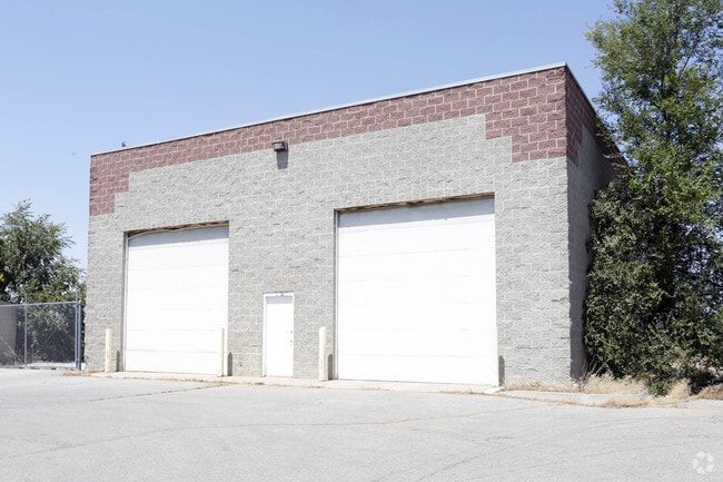
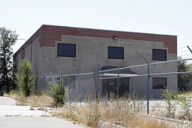
Property Detail
2363 N 2000 W
Ogden, UT
ALL OF LOT 1, VIA COMMERCIAL PARK. CONT. 1.58900 ACRES
13-374-0001
DAVIS
Miscellaneous
Utah
B and X Area of moderate flood hazard, usually the area between the limits of the 100-year and 500-year floods.
1
2025
1.59 AC
2025
Davis North
125304
Salt Lake City
NEARBY LISTINGS FOR SALE OR LEASE
DEMOGRAPHICS near 2363 N 2000 W
1 mile
3 mile
5 mile
2025 Total Population
12,923
89,919
185,318
2030 Population
13,178
92,559
193,320
Pop Growth 2025-2030
+ 1.97%
+ 2.94%
+ 4.32%
Average Age
34
35
35
2025 Total Households
3,731
27,642
57,739
HH Growth 2025-2030
+ 2.12%
+ 3.09%
+ 4.46%
Median Household Inc
$113,992
$102,770
$99,383
Avg Household Size
3.40
3.20
3.20
2025 Avg HH Vehicles
3.00
2.00
2.00
Median Home Value
$455,692
$432,812
$451,724
Median Year Built
2000
1992
1995
Nearby Places
Map Layers
Map Styles
 Street
 Aerial
Layers
 Traffic
 Biking
Places
Listings with unknown addresses are not visible on the map
- Restaurants
- Banks
- Shops
- Fitness
- Groceries
PUBLIC TRANSPORTATION
COMMUTER RAIL
Roy (FrontRunner North - Utah Transit Authority (UTA))
Drive
Walk
Distance
Roy (FrontRunner North - Utah Transit Authority (UTA))
9 min
4.4 mi
Clearfield (FrontRunner North - Utah Transit Authority (UTA))
Drive
Walk
Distance
Clearfield (FrontRunner North - Utah Transit Authority (UTA))
12 min
6.4 mi
AIRPORT
Salt Lake City International
Drive
Walk
Distance
Salt Lake City International
44 min
34.9 mi
Freight Ports
Port of Stockton
Drive
Walk
Distance
Port of Stockton
745 min
725.3 mi
Nearby Properties
Address
Land Use
TOTAL SIZE
Lot Size
Zoning
Address
Land Use
TOTAL SIZE
Lot Size
Zoning
2,657 SF
16.26 AC
Address
Land Use
TOTAL SIZE
Lot Size
Zoning
3,743 SF
8.80 AC
Address
Land Use
TOTAL SIZE
Lot Size
Zoning
151,064 SF
48.81 AC
Address
Land Use
TOTAL SIZE
Lot Size
Zoning
7,492 SF
8.96 AC
Address
Land Use
TOTAL SIZE
Lot Size
Zoning
5,481 SF
15.54 AC
Address
Land Use
TOTAL SIZE
Lot Size
Zoning
223,079 SF
22.55 AC
Address
Land Use
TOTAL SIZE
Lot Size
Zoning
57,165 SF
8.50 AC
GC
Address
Land Use
TOTAL SIZE
Lot Size
Zoning
1,440 SF
7.72 AC
Address
Land Use
TOTAL SIZE
Lot Size
Zoning
11,877 SF
5.44 AC
CC
Address
Land Use
TOTAL SIZE
Lot Size
Zoning
121,173 SF
11.74 AC
CC
Address
Land Use
TOTAL SIZE
Lot Size
Zoning
69,331 SF
7.46 AC
R2
Address
Land Use
TOTAL SIZE
Lot Size
Zoning
62,246 SF
5.37 AC
PZ
Address
Land Use
TOTAL SIZE
Lot Size
Zoning
21,980 SF
11.68 AC
Address
Land Use
TOTAL SIZE
Lot Size
Zoning
140,015 SF
12.14 AC
PZ
Address
Land Use
TOTAL SIZE
Lot Size
Zoning
88,125 SF
7.17 AC
PZ
Address
Land Use
TOTAL SIZE
Lot Size
Zoning
58,287 SF
5.18 AC
Address
Land Use
TOTAL SIZE
Lot Size
Zoning
104,180 SF
11.58 AC
I
Address
Land Use
TOTAL SIZE
Lot Size
Zoning
50,432 SF
3.86 AC
R115
Address
Land Use
TOTAL SIZE
Lot Size
Zoning
12,330 SF
20.89 AC
Address
Land Use
TOTAL SIZE
Lot Size
Zoning
45,772 SF
5 AC
Address
Land Use
TOTAL SIZE
Lot Size
Zoning
1,620 SF
3.74 AC
Address
Land Use
TOTAL SIZE
Lot Size
Zoning
20,010 SF
8.33 AC
Address
Land Use
TOTAL SIZE
Lot Size
Zoning
1,401 SF
6.37 AC
Address
Land Use
TOTAL SIZE
Lot Size
Zoning
33,818 SF
3.27 AC
Address
Land Use
TOTAL SIZE
Lot Size
Zoning
95,394 SF
8.83 AC
Address
Land Use
TOTAL SIZE
Lot Size
Zoning
52.82 AC
Address
Land Use
TOTAL SIZE
Lot Size
Zoning
16.99 AC
Address
Land Use
TOTAL SIZE
Lot Size
Zoning
22,656 SF
5.42 AC
PZ
Address
Land Use
TOTAL SIZE
Lot Size
Zoning
72,653 SF
8.78 AC
C2
The World's #1 Commercial Real Estate Marketplace
Connect with us
© 2026 CoStar Group
The information above has been obtained from sources believed reliable. While we do not doubt its accuracy we have not verified it and make no guarantee, warranty or representation about it. It is your responsibility to independently confirm its accuracy and completeness. Any projections, opinions, assumptions, or estimates used are for example only and do not represent the current or future performance of the property. The value of this transaction to you depends on tax and other factors which should be evaluated by your tax, financial, and legal advisors. You and your advisors should conduct a careful, independent investigation of the property to determine to your satisfaction the suitability of the property for your needs.