Property Record
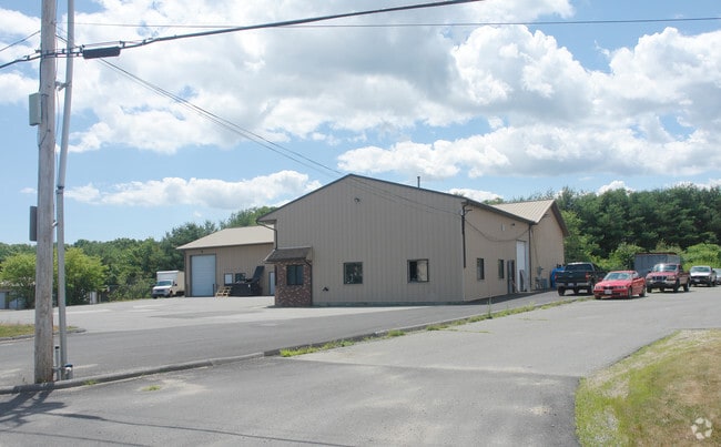
24 Hayward St, Ipswich, MA 01938


Current Lease Availabilities
NEARBY LISTINGS FOR SALE OR LEASE
Property Detail
24 Hayward St
Warehouse
Essex
X
Massachusetts
25009C0286G
1.06 AC
2025
Essex/Gloucester
2025
Boston
223300
Boston-Cambridge-Newton, MA-NH
7,944 SF
IPSW-000041D-000050-H000000
DEMOGRAPHICS near 24 Hayward St
1 Mile
3 Mile
5 Mile
2024 Total Population
6,753
12,041
32,108
2029 Population
6,741
12,034
32,141
Pop Growth 2024-2029
(0.18%)
(0.06%)
+ 0.10%
Average Age
45
45
44
2024 Total Households
3,081
5,182
12,515
HH Growth 2024-2029
(0.36%)
(0.21%)
0.00%
Median Household Inc
$93,838
$108,512
$119,183
Avg Household Size
2.20
2.30
2.50
2024 Avg HH Vehicles
2.00
2.00
2.00
Median Home Value
$595,515
$668,279
$691,290
Median Year Built
1964
1967
1966
Nearby Places
Map Layers
Map Styles
 Street
 Aerial
- Restaurants
- Banks
- Shops
- Fitness
- Groceries
PUBLIC TRANSPORTATION
TRANSIT/SUBWAY
Ipswich (Newburyport/Rockport Line - Massachusetts Bay Transportation Authority Commuter Rail (Purple Line))
DRIVE
WALK
Distance
Ipswich (Newburyport/Rockport Line - Massachusetts Bay Transportation Authority Commuter Rail (Purple Line))
3 min
12 min
0.6 mi
COMMUTER RAIL
Ipswich (Newburyport/Rockport Line - Massachusetts Bay Transportation Authority Commuter Rail (Purple Line))
DRIVE
WALK
Distance
Ipswich (Newburyport/Rockport Line - Massachusetts Bay Transportation Authority Commuter Rail (Purple Line))
3 min
12 min
0.6 mi
Rowley (Newburyport/Rockport Line - Massachusetts Bay Transportation Authority Commuter Rail (Purple Line))
DRIVE
WALK
Distance
Rowley (Newburyport/Rockport Line - Massachusetts Bay Transportation Authority Commuter Rail (Purple Line))
15 min
6.1 mi
AIRPORT
General Edward Lawrence Logan International
DRIVE
WALK
Distance
General Edward Lawrence Logan International
48 min
29.1 mi
Portsmouth International at Pease
DRIVE
WALK
Distance
Portsmouth International at Pease
54 min
36.0 mi
Manchester Boston Regional
DRIVE
WALK
Distance
Manchester Boston Regional
82 min
48.3 mi
Freight Ports
Port of Boston
DRIVE
WALK
Distance
Port of Boston
51 min
31.7 mi
Nearby Properties
Address
Land Use
TOTAL SIZE
Lot Size
Zoning
Address
Land Use
TOTAL SIZE
Lot Size
Zoning
126.58 AC
RRA
Address
Land Use
TOTAL SIZE
Lot Size
Zoning
212,956 SF
44.90 AC
R1B
Address
Land Use
TOTAL SIZE
Lot Size
Zoning
171.85 AC
RRA
Address
Land Use
TOTAL SIZE
Lot Size
Zoning
22.90 AC
HB
Address
Land Use
TOTAL SIZE
Lot Size
Zoning
46,504 SF
48 AC
RA
Address
Land Use
TOTAL SIZE
Lot Size
Zoning
284.17 AC
RRA
Address
Land Use
TOTAL SIZE
Lot Size
Zoning
2,176 SF
548.70 AC
RA
Address
Land Use
TOTAL SIZE
Lot Size
Zoning
49,530 SF
12.18 AC
RRA
Address
Land Use
TOTAL SIZE
Lot Size
Zoning
96,136 SF
13.40 AC
IR
Address
Land Use
TOTAL SIZE
Lot Size
Zoning
475 AC
RRA
Address
Land Use
TOTAL SIZE
Lot Size
Zoning
4 AC
CB
Address
Land Use
TOTAL SIZE
Lot Size
Zoning
36,838 SF
13.93 AC
HB
Address
Land Use
TOTAL SIZE
Lot Size
Zoning
4.41 AC
RRA
Address
Land Use
TOTAL SIZE
Lot Size
Zoning
1,863 SF
9.67 AC
RRA
Address
Land Use
TOTAL SIZE
Lot Size
Zoning
52,392 SF
9.98 AC
1R
Address
Land Use
TOTAL SIZE
Lot Size
Zoning
3.70 AC
HB
Address
Land Use
TOTAL SIZE
Lot Size
Zoning
6.80 AC
1R
Address
Land Use
TOTAL SIZE
Lot Size
Zoning
42,090 SF
1.94 AC
1R
Address
Land Use
TOTAL SIZE
Lot Size
Zoning
42,090 SF
1.90 AC
1R
Address
Land Use
TOTAL SIZE
Lot Size
Zoning
5.40 AC
RRA
Address
Land Use
TOTAL SIZE
Lot Size
Zoning
56,998 SF
17.23 AC
RRA
Address
Land Use
TOTAL SIZE
Lot Size
Zoning
227.89 AC
RA
Address
Land Use
TOTAL SIZE
Lot Size
Zoning
34,944 SF
18.44 AC
HB
Address
Land Use
TOTAL SIZE
Lot Size
Zoning
194.58 AC
RRC
Address
Land Use
TOTAL SIZE
Lot Size
Zoning
1,500 SF
7.55 AC
RRA
Address
Land Use
TOTAL SIZE
Lot Size
Zoning
16,374 SF
10.20 AC
HB
Address
Land Use
TOTAL SIZE
Lot Size
Zoning
3.21 AC
HB
Address
Land Use
TOTAL SIZE
Lot Size
Zoning
0.96 AC
CB
Address
Land Use
TOTAL SIZE
Lot Size
Zoning
2 AC
I
Address
Land Use
TOTAL SIZE
Lot Size
Zoning
32,166 SF
6.30 AC
HB
The World's #1 Commercial Real Estate Marketplace
Connect with us
© 2025 CoStar Group
The information above has been obtained from sources believed reliable. While we do not doubt its accuracy we have not verified it and make no guarantee, warranty or representation about it. It is your responsibility to independently confirm its accuracy and completeness. Any projections, opinions, assumptions, or estimates used are for example only and do not represent the current or future performance of the property. The value of this transaction to you depends on tax and other factors which should be evaluated by your tax, financial, and legal advisors. You and your advisors should conduct a careful, independent investigation of the property to determine to your satisfaction the suitability of the property for your needs.