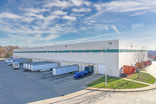
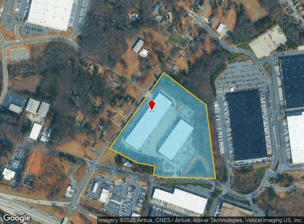
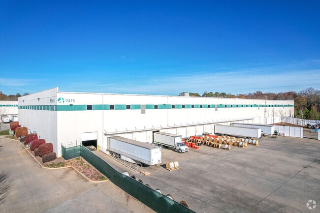
Property Record
2405 Sam Wilson Rd, Charlotte, NC 28214
NEARBY LISTINGS FOR SALE OR LEASE
Property Detail
2405 Sam Wilson Rd
055-211-31
M50-171
Industrialgeneral
Mecklenburg
X
North Carolina
3710450500M
31
2024
26.13 AC
2025
Airport/West
006005
Charlotte
251,672 SF
Charlotte-Concord-Gastonia, NC-SC
DEMOGRAPHICS near 2405 Sam Wilson Rd
1 Mile
3 Mile
5 Mile
2024 Total Population
3,288
30,235
104,767
2029 Population
3,507
32,309
112,074
Pop Growth 2024-2029
+ 6.66%
+ 6.86%
+ 6.97%
Average Age
37
38
38
2024 Total Households
1,154
11,529
39,738
HH Growth 2024-2029
+ 6.67%
+ 7.00%
+ 7.14%
Median Household Inc
$60,343
$64,406
$61,860
Avg Household Size
2.70
2.50
2.50
2024 Avg HH Vehicles
2.00
2.00
2.00
Median Home Value
$195,860
$224,796
$224,929
Median Year Built
1991
1992
1991
Nearby Places
Map Layers
Map Styles
 Street
 Aerial
- Restaurants
- Banks
- Shops
- Fitness
- Groceries
PUBLIC TRANSPORTATION
AIRPORT
Charlotte/Douglas International
DRIVE
WALK
Distance
Charlotte/Douglas International
17 min
5.6 mi
Concord-Padgett Regional
DRIVE
WALK
Distance
Concord-Padgett Regional
28 min
20.2 mi
SALE & LEASE HISTORY
LISTING DATE
SALE/LEASE

Oct 08, 2020
For Lease
Mar 14, 2017
For Lease
Nearby Properties
Address
Land Use
TOTAL SIZE
Lot Size
Zoning
Address
Land Use
TOTAL SIZE
Lot Size
Zoning
863,490 SF
93.41 AC
Address
Land Use
TOTAL SIZE
Lot Size
Zoning
416,720 SF
81 AC
I2
Address
Land Use
TOTAL SIZE
Lot Size
Zoning
15.94 AC
Address
Land Use
TOTAL SIZE
Lot Size
Zoning
625,790 SF
89.50 AC
I-2(CD)
Address
Land Use
TOTAL SIZE
Lot Size
Zoning
37.49 AC
Address
Land Use
TOTAL SIZE
Lot Size
Zoning
568,252 SF
56.05 AC
I-1(CD)
Address
Land Use
TOTAL SIZE
Lot Size
Zoning
41,508 SF
29.70 AC
Address
Land Use
TOTAL SIZE
Lot Size
Zoning
892,468 SF
14.48 AC
I2
Address
Land Use
TOTAL SIZE
Lot Size
Zoning
394,084 SF
29.35 AC
Address
Land Use
TOTAL SIZE
Lot Size
Zoning
503,550 SF
59.24 AC
I-1(CD)
Address
Land Use
TOTAL SIZE
Lot Size
Zoning
250,079 SF
52.97 AC
R3
Address
Land Use
TOTAL SIZE
Lot Size
Zoning
450,580 SF
36.74 AC
I-2(CD)
Address
Land Use
TOTAL SIZE
Lot Size
Zoning
227 AC
I-2
Address
Land Use
TOTAL SIZE
Lot Size
Zoning
3,428 SF
13.21 AC
R-17MF
Address
Land Use
TOTAL SIZE
Lot Size
Zoning
1,966 SF
36.06 AC
OFF01
Address
Land Use
TOTAL SIZE
Lot Size
Zoning
375,022 SF
32.47 AC
Address
Land Use
TOTAL SIZE
Lot Size
Zoning
471,960 SF
61.08 AC
Address
Land Use
TOTAL SIZE
Lot Size
Zoning
208,635 SF
50.01 AC
Address
Land Use
TOTAL SIZE
Lot Size
Zoning
351,824 SF
20.17 AC
I-1(CD)
Address
Land Use
TOTAL SIZE
Lot Size
Zoning
208,460 SF
23.20 AC
I-1(CD)
Address
Land Use
TOTAL SIZE
Lot Size
Zoning
171,037 SF
4.37 AC
Address
Land Use
TOTAL SIZE
Lot Size
Zoning
260,575 SF
17 AC
I-1(CD)
Address
Land Use
TOTAL SIZE
Lot Size
Zoning
249,645 SF
26.33 AC
I-1(CD)
Address
Land Use
TOTAL SIZE
Lot Size
Zoning
252,539 SF
22.58 AC
R-3
Address
Land Use
TOTAL SIZE
Lot Size
Zoning
116,515 SF
4.59 AC
I1
Address
Land Use
TOTAL SIZE
Lot Size
Zoning
255,566 SF
21.29 AC
I-1(CD)
Address
Land Use
TOTAL SIZE
Lot Size
Zoning
116,877 SF
38.58 AC
I2
Address
Land Use
TOTAL SIZE
Lot Size
Zoning
61,665 SF
49.40 AC
R3
Address
Land Use
TOTAL SIZE
Lot Size
Zoning
215,598 SF
13.68 AC
O-1(CD)
The World's #1 Commercial Real Estate Marketplace
Connect with us
© 2026 CoStar Group
The information above has been obtained from sources believed reliable. While we do not doubt its accuracy we have not verified it and make no guarantee, warranty or representation about it. It is your responsibility to independently confirm its accuracy and completeness. Any projections, opinions, assumptions, or estimates used are for example only and do not represent the current or future performance of the property. The value of this transaction to you depends on tax and other factors which should be evaluated by your tax, financial, and legal advisors. You and your advisors should conduct a careful, independent investigation of the property to determine to your satisfaction the suitability of the property for your needs.