Property Record
24101 E Orchard Rd, Aurora, CO 80016
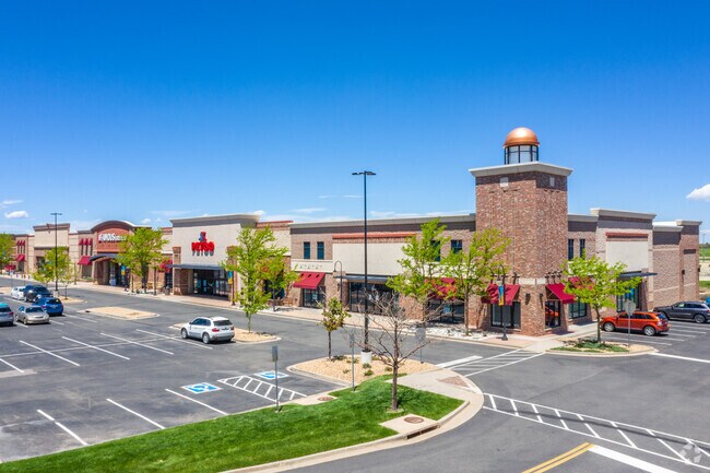
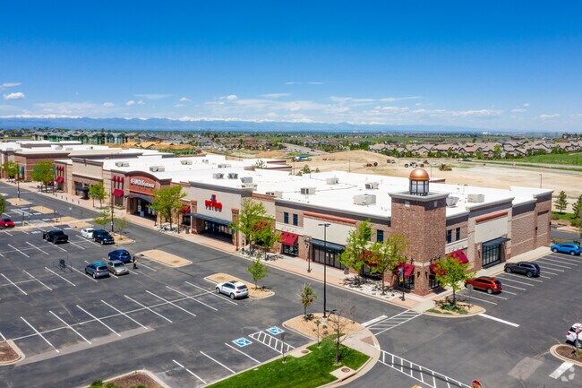

Property Detail
24101 E Orchard Rd
Denver-Aurora-Centennial, CO
SUBDIVISIONCD 058245 SUBDIVISIONNAME SOUTHLANDS SUB 6TH FLG BLOCK 001 LOT 001 LOT 1 BLK 1 SOUTHLANDS SUB 6TH FLG
2071-19-1-05-002
ARAPAHOE
Storebuilding
Colorado
B and X Area of moderate flood hazard, usually the area between the limits of the 100-year and 500-year floods.
001,1
2024
3.82 AC
2025
Southeast
007112
Denver
36,438 SF
NEARBY LISTINGS FOR SALE OR LEASE
DEMOGRAPHICS near 24101 E Orchard Rd
1 mile
3 mile
5 mile
2025 Total Population
12,352
81,227
155,784
2030 Population
12,705
82,827
158,639
Pop Growth 2025-2030
+ 2.86%
+ 1.97%
+ 1.83%
Average Age
35
38
39
2025 Total Households
3,901
26,232
51,386
HH Growth 2025-2030
+ 2.92%
+ 1.92%
+ 1.92%
Median Household Inc
$152,832
$150,206
$139,323
Avg Household Size
3.10
3.10
3.00
2025 Avg HH Vehicles
2.00
2.00
2.00
Median Home Value
$721,390
$722,578
$693,653
Median Year Built
2007
2006
2001
Nearby Places
Map Layers
Map Styles
 Street
 Aerial
Transit
 Traffic
 Biking
Places
Listings with unknown addresses are not visible on the map
- Restaurants
- Banks
- Shops
- Fitness
- Groceries
PUBLIC TRANSPORTATION
AIRPORT
Denver International
Drive
Walk
Distance
Denver International
27 min
22.4 mi
Freight Ports
Tulsa Port Of Catoosa
Drive
Walk
Distance
Tulsa Port Of Catoosa
719 min
702.3 mi
SALE & LEASE HISTORY
LISTING DATE
SALE/LEASE

Mar 26, 2018
For Lease
Nearby Properties
Address
Land Use
TOTAL SIZE
Lot Size
Zoning
Address
Land Use
TOTAL SIZE
Lot Size
Zoning
355,644 SF
123.82 AC
Address
Land Use
TOTAL SIZE
Lot Size
Zoning
502,000 SF
22.32 AC
RPD
Address
Land Use
TOTAL SIZE
Lot Size
Zoning
346,890 SF
38.99 AC
AA1
Address
Land Use
TOTAL SIZE
Lot Size
Zoning
328,000 SF
33.52 AC
PUD
Address
Land Use
TOTAL SIZE
Lot Size
Zoning
448,149 SF
33.62 AC
RE470
Address
Land Use
TOTAL SIZE
Lot Size
Zoning
137,372 SF
5.86 AC
Address
Land Use
TOTAL SIZE
Lot Size
Zoning
129,701 SF
6.56 AC
Address
Land Use
TOTAL SIZE
Lot Size
Zoning
1,635 SF
26.38 AC
AMU
Address
Land Use
TOTAL SIZE
Lot Size
Zoning
359,400 SF
20.36 AC
Address
Land Use
TOTAL SIZE
Lot Size
Zoning
5,380 SF
20.48 AC
RE470
Address
Land Use
TOTAL SIZE
Lot Size
Zoning
376,563 SF
12.17 AC
AMU
Address
Land Use
TOTAL SIZE
Lot Size
Zoning
489,120 SF
20.10 AC
RE470
Address
Land Use
TOTAL SIZE
Lot Size
Zoning
319,078 SF
18.49 AC
RE470
Address
Land Use
TOTAL SIZE
Lot Size
Zoning
40,249 SF
13.44 AC
Address
Land Use
TOTAL SIZE
Lot Size
Zoning
176,000 SF
10.83 AC
PUD
Address
Land Use
TOTAL SIZE
Lot Size
Zoning
151,246 SF
13.25 AC
RE470
Address
Land Use
TOTAL SIZE
Lot Size
Zoning
308,396 SF
19.45 AC
RPCZD
Address
Land Use
TOTAL SIZE
Lot Size
Zoning
379,109 SF
16.45 AC
Address
Land Use
TOTAL SIZE
Lot Size
Zoning
298,589 SF
14.52 AC
RPCZD
Address
Land Use
TOTAL SIZE
Lot Size
Zoning
65,120 SF
11.17 AC
Address
Land Use
TOTAL SIZE
Lot Size
Zoning
206,064 SF
25.38 AC
AMU
Address
Land Use
TOTAL SIZE
Lot Size
Zoning
40,935 SF
3.38 AC
RE470
Address
Land Use
TOTAL SIZE
Lot Size
Zoning
206,122 SF
24.97 AC
Address
Land Use
TOTAL SIZE
Lot Size
Zoning
53,736 SF
17.28 AC
RPD
Address
Land Use
TOTAL SIZE
Lot Size
Zoning
121,777 SF
10.94 AC
RE470
Address
Land Use
TOTAL SIZE
Lot Size
Zoning
91,380 SF
5.52 AC
Address
Land Use
TOTAL SIZE
Lot Size
Zoning
69,543 SF
9.95 AC
Address
Land Use
TOTAL SIZE
Lot Size
Zoning
140,000 SF
24.16 AC
AMU
Address
Land Use
TOTAL SIZE
Lot Size
Zoning
1,818.57 AC
Address
Land Use
TOTAL SIZE
Lot Size
Zoning
174,444 SF
15.64 AC
RPD
The World's #1 Commercial Real Estate Marketplace
Connect with us
© 2026 CoStar Group
The information above has been obtained from sources believed reliable. While we do not doubt its accuracy we have not verified it and make no guarantee, warranty or representation about it. It is your responsibility to independently confirm its accuracy and completeness. Any projections, opinions, assumptions, or estimates used are for example only and do not represent the current or future performance of the property. The value of this transaction to you depends on tax and other factors which should be evaluated by your tax, financial, and legal advisors. You and your advisors should conduct a careful, independent investigation of the property to determine to your satisfaction the suitability of the property for your needs.