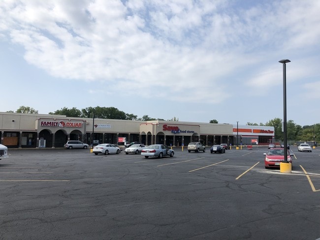
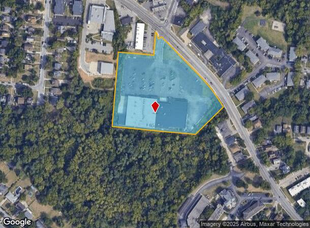
Property Record
2423 Harrison Ave, Cincinnati, OH 45211

NEARBY LISTINGS FOR SALE OR LEASE
Property Detail
2423 Harrison Ave
Cincinnati, OH-KY-IN
Samuel Dotys Sub
208-0058-0013
HARRISON AVE 5.917 ACSPT LOT 9 SAMUEL DOTYS SUB- LND ADJ PAR 13-24 CON
Regionalshoppingcenterormallwithanchorstore
Hamilton
X
Ohio
39061C0214E
9
2025
5.92 AC
2025
Queensgate
010202
Cincinnati/Dayton
61,715 SF
DEMOGRAPHICS near 2423 Harrison Ave
1 Mile
3 Mile
5 Mile
2024 Total Population
21,457
123,827
291,924
2029 Population
21,840
123,516
291,819
Pop Growth 2024-2029
+ 1.78%
(0.25%)
(0.04%)
Average Age
36
37
37
2024 Total Households
9,173
52,531
123,496
HH Growth 2024-2029
+ 1.79%
(0.32%)
0.00%
Median Household Inc
$32,894
$41,177
$48,099
Avg Household Size
2.20
2.20
2.20
2024 Avg HH Vehicles
1.00
1.00
1.00
Median Home Value
$132,043
$143,906
$167,465
Median Year Built
1966
1956
1958
Nearby Places
Map Layers
Map Styles
 Street
 Aerial
- Restaurants
- Banks
- Shops
- Fitness
- Groceries
PUBLIC TRANSPORTATION
COMMUTER RAIL
DRIVE
WALK
Distance
10 min
4.2 mi
AIRPORT
Cincinnati/Northern Kentucky International
DRIVE
WALK
Distance
Cincinnati/Northern Kentucky International
34 min
18.3 mi
SALE & LEASE HISTORY
LISTING DATE
SALE/LEASE

Sep 25, 2016
For Lease
Mar 14, 2018
For Sale
Jan 26, 2017
For Lease
Nearby Properties
Address
Land Use
TOTAL SIZE
Lot Size
Zoning
Address
Land Use
TOTAL SIZE
Lot Size
Zoning
Address
Land Use
TOTAL SIZE
Lot Size
Zoning
29.60 AC
IR
Address
Land Use
TOTAL SIZE
Lot Size
Zoning
17,857 SF
26.60 AC
CGA
Address
Land Use
TOTAL SIZE
Lot Size
Zoning
Address
Land Use
TOTAL SIZE
Lot Size
Zoning
2.51 AC
MG
Address
Land Use
TOTAL SIZE
Lot Size
Zoning
8.18 AC
SF4
Address
Land Use
TOTAL SIZE
Lot Size
Zoning
50,350 SF
15.41 AC
MG
Address
Land Use
TOTAL SIZE
Lot Size
Zoning
2.16 AC
MG
Address
Land Use
TOTAL SIZE
Lot Size
Zoning
20,199 SF
9.82 AC
SF10
Address
Land Use
TOTAL SIZE
Lot Size
Zoning
Address
Land Use
TOTAL SIZE
Lot Size
Zoning
6,537 SF
12.55 AC
Address
Land Use
TOTAL SIZE
Lot Size
Zoning
22.17 AC
Address
Land Use
TOTAL SIZE
Lot Size
Zoning
8.66 AC
SF2
Address
Land Use
TOTAL SIZE
Lot Size
Zoning
125,405 SF
16.69 AC
SF6
Address
Land Use
TOTAL SIZE
Lot Size
Zoning
Address
Land Use
TOTAL SIZE
Lot Size
Zoning
6.15 AC
SF2
Address
Land Use
TOTAL SIZE
Lot Size
Zoning
6,000 SF
11.92 AC
G
Address
Land Use
TOTAL SIZE
Lot Size
Zoning
7.33 AC
Address
Land Use
TOTAL SIZE
Lot Size
Zoning
7.27 AC
MG
Address
Land Use
TOTAL SIZE
Lot Size
Zoning
8.57 AC
Address
Land Use
TOTAL SIZE
Lot Size
Zoning
62,160 SF
13.70 AC
RM20
Address
Land Use
TOTAL SIZE
Lot Size
Zoning
4.60 AC
SF6
Address
Land Use
TOTAL SIZE
Lot Size
Zoning
55,572 SF
6.12 AC
C
Address
Land Use
TOTAL SIZE
Lot Size
Zoning
169,636 SF
20.22 AC
IR
Address
Land Use
TOTAL SIZE
Lot Size
Zoning
14.01 AC
CGA
Address
Land Use
TOTAL SIZE
Lot Size
Zoning
10,036 SF
22.06 AC
RM20
Address
Land Use
TOTAL SIZE
Lot Size
Zoning
1,329 SF
3.16 AC
SF4
Address
Land Use
TOTAL SIZE
Lot Size
Zoning
148,224 SF
5.50 AC
RM12
Address
Land Use
TOTAL SIZE
Lot Size
Zoning
19,730 SF
0.16 AC
SF2
Address
Land Use
TOTAL SIZE
Lot Size
Zoning
2,400 SF
1.49 AC
MG
The World's #1 Commercial Real Estate Marketplace
Connect with us
© 2026 CoStar Group
The information above has been obtained from sources believed reliable. While we do not doubt its accuracy we have not verified it and make no guarantee, warranty or representation about it. It is your responsibility to independently confirm its accuracy and completeness. Any projections, opinions, assumptions, or estimates used are for example only and do not represent the current or future performance of the property. The value of this transaction to you depends on tax and other factors which should be evaluated by your tax, financial, and legal advisors. You and your advisors should conduct a careful, independent investigation of the property to determine to your satisfaction the suitability of the property for your needs.