Property Record
2430 N Fielder Rd, Arlington, TX 76012
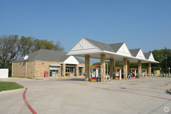

Property Detail
2430 N Fielder Rd
Dallas-Fort Worth-Arlington, TX
LEGACY HEIGHTS ADDN BLOCK 1 LOT 1
40058018
Tarrant
Commercialnec
Texas
AE The base floodplain where base flood elevations are provided. AE Zones are now used on new format FIRMs instead of A1-A30 Zones.
1
2025
1 AC
2025
North Arlington
113108
Dallas/Ft Worth
2,812 SF
NEARBY LISTINGS FOR SALE OR LEASE
DEMOGRAPHICS near 2430 N Fielder Rd
1 mile
3 mile
5 mile
2025 Total Population
4,546
89,079
292,488
2030 Population
4,731
94,163
308,693
Pop Growth 2025-2030
+ 4.07%
+ 5.71%
+ 5.54%
Average Age
45
37
37
2025 Total Households
1,817
38,245
117,689
HH Growth 2025-2030
+ 4.18%
+ 5.86%
+ 5.69%
Median Household Inc
$116,205
$66,758
$66,594
Avg Household Size
2.50
2.30
2.40
2025 Avg HH Vehicles
2.00
2.00
2.00
Median Home Value
$380,987
$347,514
$316,862
Median Year Built
1978
1983
1982
Nearby Places
Map Layers
Map Styles
 Street
 Aerial
Layers
 Traffic
 Biking
Places
Listings with unknown addresses are not visible on the map
- Restaurants
- Banks
- Shops
- Fitness
- Groceries
PUBLIC TRANSPORTATION
COMMUTER RAIL
Drive
Walk
Distance
11 min
3.4 mi
Drive
Walk
Distance
16 min
7.8 mi
AIRPORT
Dallas-Fort Worth International
Drive
Walk
Distance
Dallas-Fort Worth International
25 min
14.5 mi
Dallas Love Field
Drive
Walk
Distance
Dallas Love Field
36 min
23.2 mi
Nearby Properties
Address
Land Use
TOTAL SIZE
Lot Size
Zoning
Address
Land Use
TOTAL SIZE
Lot Size
Zoning
378,182 SF
5.02 AC
Address
Land Use
TOTAL SIZE
Lot Size
Zoning
1,129,022 SF
16.84 AC
Address
Land Use
TOTAL SIZE
Lot Size
Zoning
492,970 SF
44.82 AC
Address
Land Use
TOTAL SIZE
Lot Size
Zoning
458,819 SF
15.88 AC
Address
Land Use
TOTAL SIZE
Lot Size
Zoning
521,200 SF
7.99 AC
Address
Land Use
TOTAL SIZE
Lot Size
Zoning
548,095 SF
7.19 AC
Address
Land Use
TOTAL SIZE
Lot Size
Zoning
578,395 SF
6.22 AC
Address
Land Use
TOTAL SIZE
Lot Size
Zoning
548,806 SF
5.56 AC
Address
Land Use
TOTAL SIZE
Lot Size
Zoning
324,303 SF
23.15 AC
Address
Land Use
TOTAL SIZE
Lot Size
Zoning
1,544,748 SF
76.25 AC
Address
Land Use
TOTAL SIZE
Lot Size
Zoning
260,590 SF
15.30 AC
Address
Land Use
TOTAL SIZE
Lot Size
Zoning
313,349 SF
15.39 AC
Address
Land Use
TOTAL SIZE
Lot Size
Zoning
345,216 SF
21.64 AC
Address
Land Use
TOTAL SIZE
Lot Size
Zoning
334,660 SF
17.59 AC
Address
Land Use
TOTAL SIZE
Lot Size
Zoning
288,378 SF
15.40 AC
Address
Land Use
TOTAL SIZE
Lot Size
Zoning
352,866 SF
15.67 AC
Address
Land Use
TOTAL SIZE
Lot Size
Zoning
247,688 SF
11.75 AC
Address
Land Use
TOTAL SIZE
Lot Size
Zoning
198,570 SF
9.69 AC
Address
Land Use
TOTAL SIZE
Lot Size
Zoning
320,311 SF
15.06 AC
Address
Land Use
TOTAL SIZE
Lot Size
Zoning
255,599 SF
14.25 AC
Address
Land Use
TOTAL SIZE
Lot Size
Zoning
225,117 SF
12.29 AC
Address
Land Use
TOTAL SIZE
Lot Size
Zoning
217,761 SF
12.05 AC
Address
Land Use
TOTAL SIZE
Lot Size
Zoning
234,375 SF
10.99 AC
Address
Land Use
TOTAL SIZE
Lot Size
Zoning
212,947 SF
10.28 AC
Address
Land Use
TOTAL SIZE
Lot Size
Zoning
193,868 SF
11.99 AC
Address
Land Use
TOTAL SIZE
Lot Size
Zoning
325,179 SF
15.64 AC
Address
Land Use
TOTAL SIZE
Lot Size
Zoning
538,747 SF
2.21 AC
Address
Land Use
TOTAL SIZE
Lot Size
Zoning
206,098 SF
10 AC
Address
Land Use
TOTAL SIZE
Lot Size
Zoning
405,188 SF
5.98 AC
Address
Land Use
TOTAL SIZE
Lot Size
Zoning
166,964 SF
10.42 AC
The World's #1 Commercial Real Estate Marketplace
Connect with us
© 2026 CoStar Group
The information above has been obtained from sources believed reliable. While we do not doubt its accuracy we have not verified it and make no guarantee, warranty or representation about it. It is your responsibility to independently confirm its accuracy and completeness. Any projections, opinions, assumptions, or estimates used are for example only and do not represent the current or future performance of the property. The value of this transaction to you depends on tax and other factors which should be evaluated by your tax, financial, and legal advisors. You and your advisors should conduct a careful, independent investigation of the property to determine to your satisfaction the suitability of the property for your needs.