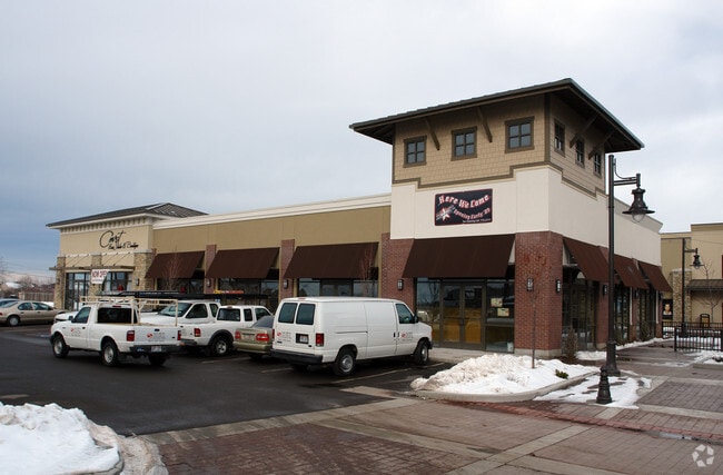
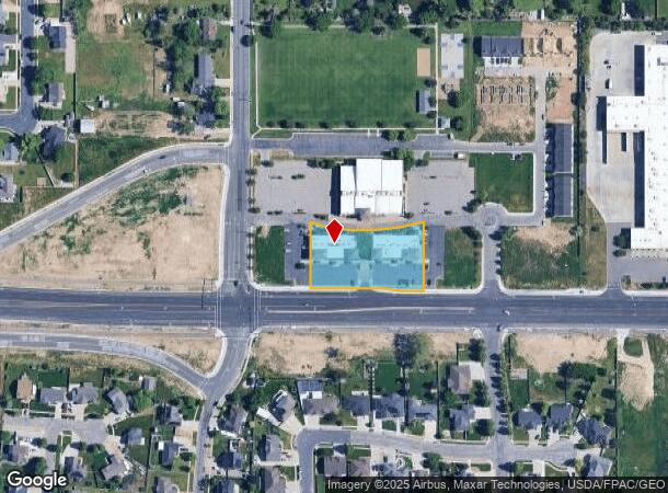
Property Record
2432 W 1700 S, Syracuse, UT 84075

NEARBY LISTINGS FOR SALE OR LEASE
Property Detail
2432 W 1700 S
Ogden-Clearfield, UT
ALL OF LOT 4, SYRACUSE WEST PHASE 1 SUBDIVISION. CONT. 1.28000 ACRES LESS & EXCEPT THAT PART OF SD LOT 4 CONV IN WARRANTY DEED RECORDED 04/23/2021 AS E# 3375142 BK 7745 PG 2329 DESC AS FOLLOWS:
12-710-0014
Davis
Stripcommercialcenter
Utah
2025
4
2025
1.16 AC
125407
Davis/Weber Counties
7,701 SF
Salt Lake City
DEMOGRAPHICS near 2432 W 1700 S
1 Mile
3 Mile
5 Mile
2024 Total Population
11,203
65,934
145,310
2029 Population
11,939
70,265
155,046
Pop Growth 2024-2029
+ 6.57%
+ 6.57%
+ 6.70%
Average Age
34
33
33
2024 Total Households
3,038
18,219
43,354
HH Growth 2024-2029
+ 6.75%
+ 6.72%
+ 6.86%
Median Household Inc
$115,896
$106,636
$88,607
Avg Household Size
3.70
3.60
3.30
2024 Avg HH Vehicles
3.00
3.00
2.00
Median Home Value
$432,835
$421,279
$393,503
Median Year Built
2003
2002
1999
Nearby Places
Map Layers
Map Styles
 Street
 Aerial
- Restaurants
- Banks
- Shops
- Fitness
- Groceries
PUBLIC TRANSPORTATION
COMMUTER RAIL
Clearfield (FrontRunner North - Utah Transit Authority (UTA))
DRIVE
WALK
Distance
Clearfield (FrontRunner North - Utah Transit Authority (UTA))
9 min
4.3 mi
Layton (FrontRunner North - Utah Transit Authority (UTA))
DRIVE
WALK
Distance
Layton (FrontRunner North - Utah Transit Authority (UTA))
12 min
6.8 mi
AIRPORT
Salt Lake City International
DRIVE
WALK
Distance
Salt Lake City International
42 min
32.4 mi
Freight Ports
Port of Stockton
DRIVE
WALK
Distance
Port of Stockton
742 min
722.7 mi
SALE & LEASE HISTORY
LISTING DATE
SALE/LEASE

Apr 08, 2022
For Lease
Nearby Properties
Address
Land Use
TOTAL SIZE
Lot Size
Zoning
Address
Land Use
TOTAL SIZE
Lot Size
Zoning
399,630 SF
31.55 AC
I
Address
Land Use
TOTAL SIZE
Lot Size
Zoning
664,440 SF
37.07 AC
Address
Land Use
TOTAL SIZE
Lot Size
Zoning
217,412 SF
13.23 AC
RS
Address
Land Use
TOTAL SIZE
Lot Size
Zoning
151,064 SF
48.81 AC
Address
Land Use
TOTAL SIZE
Lot Size
Zoning
86,213 SF
12.27 AC
Address
Land Use
TOTAL SIZE
Lot Size
Zoning
123,824 SF
41.89 AC
M1
Address
Land Use
TOTAL SIZE
Lot Size
Zoning
121,332 SF
44.40 AC
Address
Land Use
TOTAL SIZE
Lot Size
Zoning
123,445 SF
27.94 AC
M1
Address
Land Use
TOTAL SIZE
Lot Size
Zoning
27,763 SF
11.41 AC
Address
Land Use
TOTAL SIZE
Lot Size
Zoning
638,065 SF
33.77 AC
M1
Address
Land Use
TOTAL SIZE
Lot Size
Zoning
1,540 SF
11.52 AC
Address
Land Use
TOTAL SIZE
Lot Size
Zoning
5,481 SF
15.54 AC
Address
Land Use
TOTAL SIZE
Lot Size
Zoning
503,599 SF
47.71 AC
M1
Address
Land Use
TOTAL SIZE
Lot Size
Zoning
199,214 SF
19.59 AC
C1
Address
Land Use
TOTAL SIZE
Lot Size
Zoning
57,165 SF
8.50 AC
GC
Address
Land Use
TOTAL SIZE
Lot Size
Zoning
147,184 SF
2.53 AC
Address
Land Use
TOTAL SIZE
Lot Size
Zoning
46,207 SF
6.09 AC
A1
Address
Land Use
TOTAL SIZE
Lot Size
Zoning
293,860 SF
20.61 AC
M1
Address
Land Use
TOTAL SIZE
Lot Size
Zoning
11,877 SF
5.44 AC
CC
Address
Land Use
TOTAL SIZE
Lot Size
Zoning
121,173 SF
11.74 AC
CC
Address
Land Use
TOTAL SIZE
Lot Size
Zoning
72,301 SF
11.98 AC
A1
Address
Land Use
TOTAL SIZE
Lot Size
Zoning
69,331 SF
7.46 AC
R2
Address
Land Use
TOTAL SIZE
Lot Size
Zoning
76,267 SF
11.61 AC
R1
The World's #1 Commercial Real Estate Marketplace
Connect with us
© 2025 CoStar Group
The information above has been obtained from sources believed reliable. While we do not doubt its accuracy we have not verified it and make no guarantee, warranty or representation about it. It is your responsibility to independently confirm its accuracy and completeness. Any projections, opinions, assumptions, or estimates used are for example only and do not represent the current or future performance of the property. The value of this transaction to you depends on tax and other factors which should be evaluated by your tax, financial, and legal advisors. You and your advisors should conduct a careful, independent investigation of the property to determine to your satisfaction the suitability of the property for your needs.