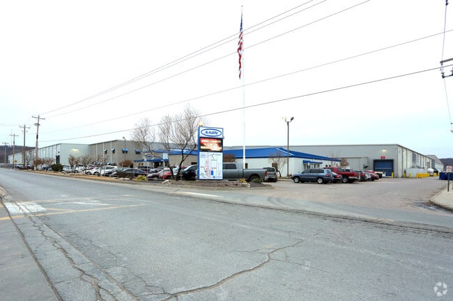
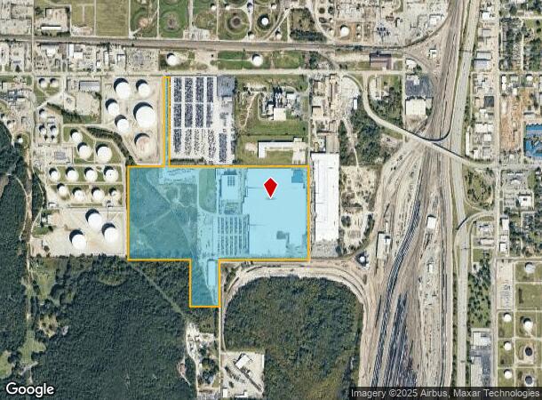
Property Record
2440 S Yukon Ave, Tulsa, OK 74107

NEARBY LISTINGS FOR SALE OR LEASE
Property Detail
2440 S Yukon Ave
99215-92-15-18720
Unplatted
Lightindustrial
PRT NW & NE BEG 1851.21E & 50S NWC NW TH E50 S1269.98 E2066.6 S1320 W1320 S660 W415 N660 W889.02 N1319.08 E507.71 N1269.90 POB LESS E50 FOR RD SEC 15 19 12 NE 87.290ACS
AE
Tulsa
40113C1245K
Oklahoma
2025
87.29 AC
2025
West Tulsa
006600
Tulsa
1,123,266 SF
Tulsa, OK
DEMOGRAPHICS near 2440 S Yukon Ave
1 Mile
3 Mile
5 Mile
2024 Total Population
2,038
48,085
140,600
2029 Population
2,062
50,242
146,698
Pop Growth 2024-2029
+ 1.18%
+ 4.49%
+ 4.34%
Average Age
34
40
39
2024 Total Households
1,085
22,257
62,121
HH Growth 2024-2029
+ 1.11%
+ 4.83%
+ 4.52%
Median Household Inc
$26,377
$53,170
$49,783
Avg Household Size
1.70
2.00
2.10
2024 Avg HH Vehicles
1.00
2.00
2.00
Median Home Value
$165,789
$166,456
$175,692
Median Year Built
1980
1958
1960
Nearby Places
Map Layers
Map Styles
 Street
 Aerial
- Restaurants
- Banks
- Shops
- Fitness
- Groceries
PUBLIC TRANSPORTATION
AIRPORT
Tulsa International
DRIVE
WALK
Distance
Tulsa International
22 min
12.0 mi
Freight Ports
DRIVE
WALK
Distance
31 min
21.2 mi
Nearby Properties
Address
Land Use
TOTAL SIZE
Lot Size
Zoning
Address
Land Use
TOTAL SIZE
Lot Size
Zoning
565,000 SF
10.62 AC
CBD
Address
Land Use
TOTAL SIZE
Lot Size
Zoning
1,303,210 SF
7.94 AC
OH
Address
Land Use
TOTAL SIZE
Lot Size
Zoning
249,092 SF
11.75 AC
CBD
Address
Land Use
TOTAL SIZE
Lot Size
Zoning
692,068 SF
1.03 AC
CBD
Address
Land Use
TOTAL SIZE
Lot Size
Zoning
423,825 SF
23.97 AC
CBD
Address
Land Use
TOTAL SIZE
Lot Size
Zoning
483,697 SF
5.31 AC
CBD
Address
Land Use
TOTAL SIZE
Lot Size
Zoning
49,992 SF
33.23 AC
AG
Address
Land Use
TOTAL SIZE
Lot Size
Zoning
528,432 SF
0.01 AC
CBD
Address
Land Use
TOTAL SIZE
Lot Size
Zoning
110,922 SF
1.59 AC
RM2
Address
Land Use
TOTAL SIZE
Lot Size
Zoning
74,284 SF
3.61 AC
IM
Address
Land Use
TOTAL SIZE
Lot Size
Zoning
254,800 SF
2.07 AC
CBD
Address
Land Use
TOTAL SIZE
Lot Size
Zoning
132,305 SF
2.07 AC
CBD
Address
Land Use
TOTAL SIZE
Lot Size
Zoning
114,791 SF
23.40 AC
RE
Address
Land Use
TOTAL SIZE
Lot Size
Zoning
87,606 SF
8.25 AC
CBD
Address
Land Use
TOTAL SIZE
Lot Size
Zoning
303 SF
33.64 AC
RS2
Address
Land Use
TOTAL SIZE
Lot Size
Zoning
266,944 SF
2.07 AC
CBD
Address
Land Use
TOTAL SIZE
Lot Size
Zoning
124,033 SF
4.18 AC
CBD
Address
Land Use
TOTAL SIZE
Lot Size
Zoning
315,434 SF
2.07 AC
CBD
Address
Land Use
TOTAL SIZE
Lot Size
Zoning
355,620 SF
4.78 AC
CBD
Address
Land Use
TOTAL SIZE
Lot Size
Zoning
56,049 SF
1.14 AC
CBD
Address
Land Use
TOTAL SIZE
Lot Size
Zoning
84,560 SF
1.92 AC
CBD
Address
Land Use
TOTAL SIZE
Lot Size
Zoning
53,337 SF
3.34 AC
FBC
Address
Land Use
TOTAL SIZE
Lot Size
Zoning
410,400 SF
1.76 AC
CBD
Address
Land Use
TOTAL SIZE
Lot Size
Zoning
1,298,531 SF
2.49 AC
CBD
Address
Land Use
TOTAL SIZE
Lot Size
Zoning
137,215 SF
5.08 AC
RM3
Address
Land Use
TOTAL SIZE
Lot Size
Zoning
236,413 SF
2.07 AC
CBD
Address
Land Use
TOTAL SIZE
Lot Size
Zoning
112,506 SF
2.14 AC
CBD
Address
Land Use
TOTAL SIZE
Lot Size
Zoning
88,702 SF
8.27 AC
IM
Address
Land Use
TOTAL SIZE
Lot Size
Zoning
21,693 SF
4.24 AC
Address
Land Use
TOTAL SIZE
Lot Size
Zoning
63,384 SF
0.56 AC
OH
The World's #1 Commercial Real Estate Marketplace
Connect with us
© 2026 CoStar Group
The information above has been obtained from sources believed reliable. While we do not doubt its accuracy we have not verified it and make no guarantee, warranty or representation about it. It is your responsibility to independently confirm its accuracy and completeness. Any projections, opinions, assumptions, or estimates used are for example only and do not represent the current or future performance of the property. The value of this transaction to you depends on tax and other factors which should be evaluated by your tax, financial, and legal advisors. You and your advisors should conduct a careful, independent investigation of the property to determine to your satisfaction the suitability of the property for your needs.