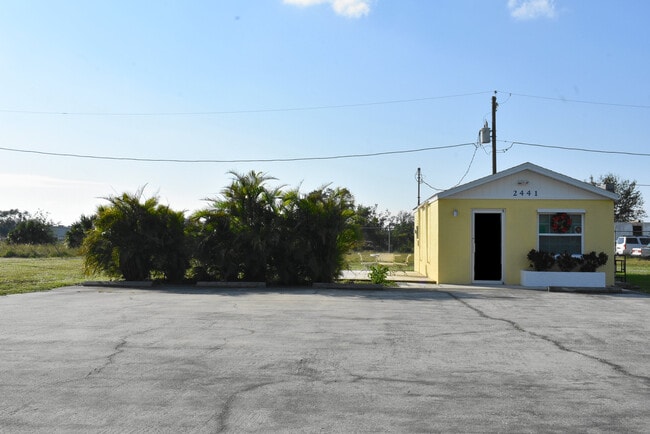
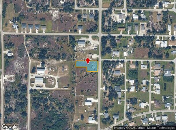
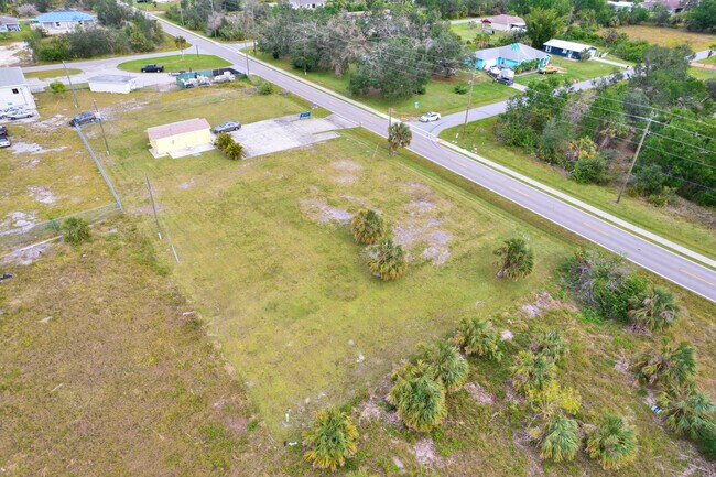
Property Record
2448 Flotilla Dr, Punta Gorda, FL 33983
NEARBY LISTINGS FOR SALE OR LEASE
Property Detail
2448 Flotilla Dr
Punta Gorda, FL
Harbour Heights
402315378008
HARBOUR HEIGHTS SEC5 BLK0031 LT 12 & 13 85/67 DC582/978 1005/2038/48(DHB) 1029/1435 2621/1378 3570/1132 4360/561 RES4412/622 4515/1114 4798/1011 3266240 HBH 005 0031 0014 HARB HTS SEC 5 BLK 31 LOTS 14 & 15 & 16 85/68 1029/1434 2621/
Commercialacreage
Charlotte
AE
Florida
12015C0232G
12,13
2024
0.61 AC
2025
Charlotte County
020101
Southwest Florida
DEMOGRAPHICS near 2448 Flotilla Dr
1 Mile
3 Mile
5 Mile
2024 Total Population
3,041
25,204
56,695
2029 Population
3,631
30,418
67,765
Pop Growth 2024-2029
+ 19.40%
+ 20.69%
+ 19.53%
Average Age
49
53
51
2024 Total Households
1,320
11,679
25,971
HH Growth 2024-2029
+ 19.62%
+ 21.03%
+ 19.89%
Median Household Inc
$67,086
$53,594
$54,606
Avg Household Size
2.20
2.10
2.10
2024 Avg HH Vehicles
2.00
2.00
2.00
Median Home Value
$279,999
$239,105
$227,750
Median Year Built
1988
1993
1990
Nearby Places
- Restaurants
- Banks
- Shops
- Fitness
- Groceries
PUBLIC TRANSPORTATION
AIRPORT
Punta Gorda
DRIVE
WALK
Distance
Punta Gorda
14 min
8.2 mi
Freight Ports
Port Manatee
DRIVE
WALK
Distance
Port Manatee
81 min
69.0 mi
SALE & LEASE HISTORY
LISTING DATE
SALE/LEASE

Dec 14, 2022
For Sale
Nearby Properties
Address
Land Use
TOTAL SIZE
Lot Size
Zoning
Address
Land Use
TOTAL SIZE
Lot Size
Zoning
121,585 SF
696.03 AC
RE1
Address
Land Use
TOTAL SIZE
Lot Size
Zoning
249,777 SF
48 AC
RMF10
Address
Land Use
TOTAL SIZE
Lot Size
Zoning
254.31 AC
PD
Address
Land Use
TOTAL SIZE
Lot Size
Zoning
125.54 AC
PD
Address
Land Use
TOTAL SIZE
Lot Size
Zoning
84,500 SF
5.59 AC
CG
Address
Land Use
TOTAL SIZE
Lot Size
Zoning
116,186 SF
20.02 AC
RMF10
Address
Land Use
TOTAL SIZE
Lot Size
Zoning
98,552 SF
11.42 AC
CG
Address
Land Use
TOTAL SIZE
Lot Size
Zoning
66,461 SF
10.86 AC
CG
Address
Land Use
TOTAL SIZE
Lot Size
Zoning
51,248 SF
15.96 AC
PD
Address
Land Use
TOTAL SIZE
Lot Size
Zoning
2,148 SF
121.95 AC
PD
Address
Land Use
TOTAL SIZE
Lot Size
Zoning
1,556 SF
23.08 AC
CG
Address
Land Use
TOTAL SIZE
Lot Size
Zoning
81,226 SF
11.40 AC
OMI
Address
Land Use
TOTAL SIZE
Lot Size
Zoning
34,983 SF
18.79 AC
RE1
Address
Land Use
TOTAL SIZE
Lot Size
Zoning
60.56 AC
PD
Address
Land Use
TOTAL SIZE
Lot Size
Zoning
74,434 SF
4.42 AC
CG
Address
Land Use
TOTAL SIZE
Lot Size
Zoning
23,566 SF
20.33 AC
RMF10
Address
Land Use
TOTAL SIZE
Lot Size
Zoning
31,194 SF
7.93 AC
CG
Address
Land Use
TOTAL SIZE
Lot Size
Zoning
106.30 AC
PD
Address
Land Use
TOTAL SIZE
Lot Size
Zoning
34,159 SF
23.55 AC
PD
Address
Land Use
TOTAL SIZE
Lot Size
Zoning
14,945 SF
2.47 AC
RMF15
Address
Land Use
TOTAL SIZE
Lot Size
Zoning
11,248 SF
91.25 AC
RMF15
Address
Land Use
TOTAL SIZE
Lot Size
Zoning
22,306 SF
1.97 AC
CG
Address
Land Use
TOTAL SIZE
Lot Size
Zoning
32,938 SF
9.62 AC
RE1
Address
Land Use
TOTAL SIZE
Lot Size
Zoning
24,020 SF
13.35 AC
II
Address
Land Use
TOTAL SIZE
Lot Size
Zoning
28.40 AC
PD
Address
Land Use
TOTAL SIZE
Lot Size
Zoning
66,050 SF
7.74 AC
CG
Address
Land Use
TOTAL SIZE
Lot Size
Zoning
8,750 SF
21.19 AC
CG
Address
Land Use
TOTAL SIZE
Lot Size
Zoning
9,368 SF
2.80 AC
RE1
Address
Land Use
TOTAL SIZE
Lot Size
Zoning
2,400 SF
1.65 AC
IG
Address
Land Use
TOTAL SIZE
Lot Size
Zoning
23.31 AC
CG
The World's #1 Commercial Real Estate Marketplace
Connect with us
© 2025 CoStar Group
The information above has been obtained from sources believed reliable. While we do not doubt its accuracy we have not verified it and make no guarantee, warranty or representation about it. It is your responsibility to independently confirm its accuracy and completeness. Any projections, opinions, assumptions, or estimates used are for example only and do not represent the current or future performance of the property. The value of this transaction to you depends on tax and other factors which should be evaluated by your tax, financial, and legal advisors. You and your advisors should conduct a careful, independent investigation of the property to determine to your satisfaction the suitability of the property for your needs.