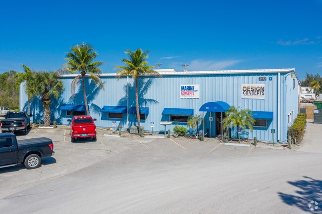
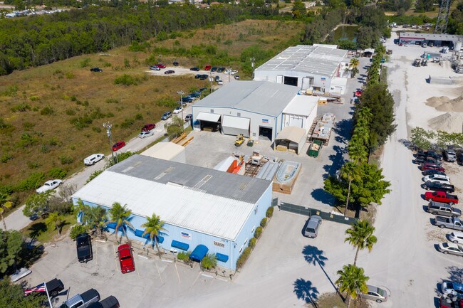
Property Record
2443 Sw Pine Island Rd, Cape Coral, FL 33991
NEARBY LISTINGS FOR SALE OR LEASE
Property Detail
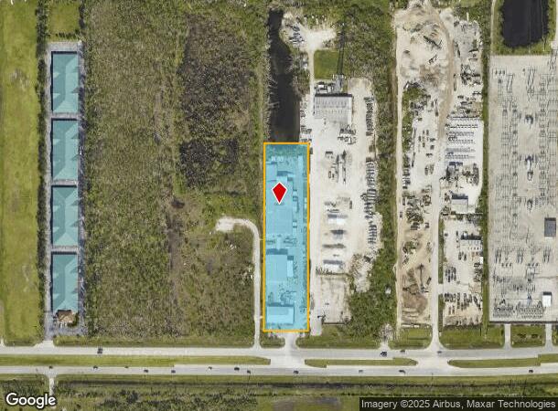
2443 Sw Pine Island Rd
Cape Coral-Fort Myers, FL
Pine Island Rd Corridor
17-44-23-C3-00007.0000
LT 5 OF E 1/2 OF W 1/2 OF SE 1/4 OF SE 1/4 LESS OR 2309/285
Lightindustrial
Lee
AE
Florida
12071C0244G
5
2024
2.76 AC
2025
Cape Coral
010419
Southwest Florida
44,439 SF
DEMOGRAPHICS near 2443 Sw Pine Island Rd
1 Mile
3 Mile
5 Mile
2024 Total Population
4,663
45,448
120,862
2029 Population
5,647
54,501
144,241
Pop Growth 2024-2029
+ 21.10%
+ 19.92%
+ 19.34%
Average Age
42
41
42
2024 Total Households
1,705
16,368
44,161
HH Growth 2024-2029
+ 20.41%
+ 19.48%
+ 18.83%
Median Household Inc
$74,532
$73,978
$70,989
Avg Household Size
2.70
2.70
2.60
2024 Avg HH Vehicles
2.00
2.00
2.00
Median Home Value
$307,705
$292,111
$282,870
Median Year Built
2010
2006
2003
Nearby Places
Map Layers
Map Styles
 Street
 Aerial
- Restaurants
- Banks
- Shops
- Fitness
- Groceries
PUBLIC TRANSPORTATION
AIRPORT
Punta Gorda
DRIVE
WALK
Distance
Punta Gorda
36 min
22.3 mi
Southwest Florida International
DRIVE
WALK
Distance
Southwest Florida International
40 min
24.8 mi
Freight Ports
Port Manatee
DRIVE
WALK
Distance
Port Manatee
116 min
93.9 mi
Nearby Properties
Address
Land Use
TOTAL SIZE
Lot Size
Zoning
Address
Land Use
TOTAL SIZE
Lot Size
Zoning
507,243 SF
115.38 AC
A
Address
Land Use
TOTAL SIZE
Lot Size
Zoning
25.99 AC
RML
Address
Land Use
TOTAL SIZE
Lot Size
Zoning
231,454 SF
14.53 AC
CC
Address
Land Use
TOTAL SIZE
Lot Size
Zoning
300,366 SF
10.61 AC
RPUD
Address
Land Use
TOTAL SIZE
Lot Size
Zoning
7.82 AC
CORR
Address
Land Use
TOTAL SIZE
Lot Size
Zoning
264,848 SF
10.36 AC
CORR
Address
Land Use
TOTAL SIZE
Lot Size
Zoning
4.89 AC
C-1
Address
Land Use
TOTAL SIZE
Lot Size
Zoning
239,211 SF
56.31 AC
INST
Address
Land Use
TOTAL SIZE
Lot Size
Zoning
27.77 AC
RML
Address
Land Use
TOTAL SIZE
Lot Size
Zoning
149,829 SF
5.70 AC
R-3
Address
Land Use
TOTAL SIZE
Lot Size
Zoning
153,651 SF
17.17 AC
R1-B
Address
Land Use
TOTAL SIZE
Lot Size
Zoning
123,133 SF
8.26 AC
C
Address
Land Use
TOTAL SIZE
Lot Size
Zoning
147,599 SF
5.72 AC
RML
Address
Land Use
TOTAL SIZE
Lot Size
Zoning
142,379 SF
3.27 AC
Address
Land Use
TOTAL SIZE
Lot Size
Zoning
62,119 SF
6.50 AC
CORR
Address
Land Use
TOTAL SIZE
Lot Size
Zoning
64,461 SF
27.05 AC
RD-D
Address
Land Use
TOTAL SIZE
Lot Size
Zoning
78,298 SF
12.73 AC
CORR
Address
Land Use
TOTAL SIZE
Lot Size
Zoning
28,560 SF
5.08 AC
P1-W
Address
Land Use
TOTAL SIZE
Lot Size
Zoning
102,818 SF
8.60 AC
CORR
Address
Land Use
TOTAL SIZE
Lot Size
Zoning
78,938 SF
11.39 AC
VILL
Address
Land Use
TOTAL SIZE
Lot Size
Zoning
93,636 SF
4.46 AC
C-1
Address
Land Use
TOTAL SIZE
Lot Size
Zoning
78,740 SF
4.51 AC
C-1
Address
Land Use
TOTAL SIZE
Lot Size
Zoning
47,423 SF
13.86 AC
R1-D
Address
Land Use
TOTAL SIZE
Lot Size
Zoning
58,318 SF
4.99 AC
C
Address
Land Use
TOTAL SIZE
Lot Size
Zoning
100,325 SF
4.86 AC
C-1
Address
Land Use
TOTAL SIZE
Lot Size
Zoning
56,092 SF
4.52 AC
CORR
Address
Land Use
TOTAL SIZE
Lot Size
Zoning
12,252 SF
12.37 AC
CC
Address
Land Use
TOTAL SIZE
Lot Size
Zoning
154,947 SF
13.83 AC
CORR
Address
Land Use
TOTAL SIZE
Lot Size
Zoning
20.12 AC
RD
Address
Land Use
TOTAL SIZE
Lot Size
Zoning
291,158 SF
25.64 AC
INS
The World's #1 Commercial Real Estate Marketplace
Connect with us
© 2026 CoStar Group
The information above has been obtained from sources believed reliable. While we do not doubt its accuracy we have not verified it and make no guarantee, warranty or representation about it. It is your responsibility to independently confirm its accuracy and completeness. Any projections, opinions, assumptions, or estimates used are for example only and do not represent the current or future performance of the property. The value of this transaction to you depends on tax and other factors which should be evaluated by your tax, financial, and legal advisors. You and your advisors should conduct a careful, independent investigation of the property to determine to your satisfaction the suitability of the property for your needs.