Property Record
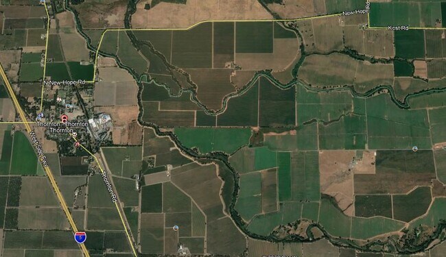
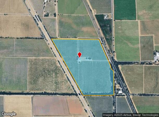
24501 N Thornton Rd, Thornton, CA 95686
NEARBY LISTINGS FOR SALE OR LEASE
Property Detail
24501 N Thornton Rd
001-180-11
San Joaquin
Orchard
California
A
132 AC
06067C0585H
Lodi
2025
Stockton/Modesto
2025
Stockton-Lodi, CA
004104
DEMOGRAPHICS near 24501 N Thornton Rd
1 Mile
3 Mile
5 Mile
2024 Total Population
82
917
1,853
2029 Population
82
912
1,853
Pop Growth 2024-2029
0.00%
(0.55%)
0.00%
Average Age
39
38
40
2024 Total Households
28
301
636
HH Growth 2024-2029
(3.57%)
(0.66%)
0.00%
Median Household Inc
$42,500
$41,638
$61,875
Avg Household Size
2.70
2.90
2.80
2024 Avg HH Vehicles
2.00
2.00
3.00
Median Home Value
$483,333
$489,285
$613,636
Median Year Built
1974
1970
1973
Nearby Places
Map Layers
Map Styles
 Street
 Aerial
- Restaurants
- Banks
- Shops
- Fitness
- Groceries
PUBLIC TRANSPORTATION
AIRPORT
Stockton Metro
DRIVE
WALK
Distance
Stockton Metro
36 min
29.5 mi
Freight Ports
Port of Stockton
DRIVE
WALK
Distance
Port of Stockton
26 min
22.0 mi
SALE & LEASE HISTORY
LISTING DATE
SALE/LEASE

Aug 28, 2018
For Sale
Nearby Properties
Address
Land Use
TOTAL SIZE
Lot Size
Zoning
Address
Land Use
TOTAL SIZE
Lot Size
Zoning
70,000 SF
79.69 AC
IG
Address
Land Use
TOTAL SIZE
Lot Size
Zoning
2,267 SF
437.17 AC
AG-80
Address
Land Use
TOTAL SIZE
Lot Size
Zoning
267.24 AC
AG40
Address
Land Use
TOTAL SIZE
Lot Size
Zoning
353.79 AC
AG40
Address
Land Use
TOTAL SIZE
Lot Size
Zoning
234.04 AC
AG-80
Address
Land Use
TOTAL SIZE
Lot Size
Zoning
1,588 SF
619.33 AC
AG40
Address
Land Use
TOTAL SIZE
Lot Size
Zoning
1,200 SF
349 AC
AG40
Address
Land Use
TOTAL SIZE
Lot Size
Zoning
1,647 SF
613.04 AC
AG40
Address
Land Use
TOTAL SIZE
Lot Size
Zoning
195.83 AC
AG40
Address
Land Use
TOTAL SIZE
Lot Size
Zoning
3,876 SF
62.75 AC
AG40
Address
Land Use
TOTAL SIZE
Lot Size
Zoning
952 SF
147.51 AC
AG40
Address
Land Use
TOTAL SIZE
Lot Size
Zoning
237.77 AC
AG40
Address
Land Use
TOTAL SIZE
Lot Size
Zoning
806 SF
2.37 AC
Address
Land Use
TOTAL SIZE
Lot Size
Zoning
2,000 SF
166.58 AC
AG40
Address
Land Use
TOTAL SIZE
Lot Size
Zoning
101.64 AC
AG-80
Address
Land Use
TOTAL SIZE
Lot Size
Zoning
158 AC
AG40
Address
Land Use
TOTAL SIZE
Lot Size
Zoning
1,747 SF
40 AC
AG40
Address
Land Use
TOTAL SIZE
Lot Size
Zoning
2,612 SF
147.83 AC
AG40
Address
Land Use
TOTAL SIZE
Lot Size
Zoning
290.37 AC
AG40
Address
Land Use
TOTAL SIZE
Lot Size
Zoning
3,472 SF
1.89 AC
CC
Address
Land Use
TOTAL SIZE
Lot Size
Zoning
840 SF
149.63 AC
AG40
Address
Land Use
TOTAL SIZE
Lot Size
Zoning
27,520 SF
4.07 AC
IL
Address
Land Use
TOTAL SIZE
Lot Size
Zoning
74.50 AC
AG40
Address
Land Use
TOTAL SIZE
Lot Size
Zoning
922.47 AC
Address
Land Use
TOTAL SIZE
Lot Size
Zoning
658 SF
24.88 AC
AG40
Address
Land Use
TOTAL SIZE
Lot Size
Zoning
1,950 SF
115.52 AC
AG40
Address
Land Use
TOTAL SIZE
Lot Size
Zoning
147 AC
AG40
Address
Land Use
TOTAL SIZE
Lot Size
Zoning
2,065 SF
52.62 AC
AG40
Address
Land Use
TOTAL SIZE
Lot Size
Zoning
123.23 AC
AG40
The World's #1 Commercial Real Estate Marketplace
Connect with us
© 2025 CoStar Group
The information above has been obtained from sources believed reliable. While we do not doubt its accuracy we have not verified it and make no guarantee, warranty or representation about it. It is your responsibility to independently confirm its accuracy and completeness. Any projections, opinions, assumptions, or estimates used are for example only and do not represent the current or future performance of the property. The value of this transaction to you depends on tax and other factors which should be evaluated by your tax, financial, and legal advisors. You and your advisors should conduct a careful, independent investigation of the property to determine to your satisfaction the suitability of the property for your needs.