Property Record
24601 Maplehurst Dr, Clinton Township, MI 48036
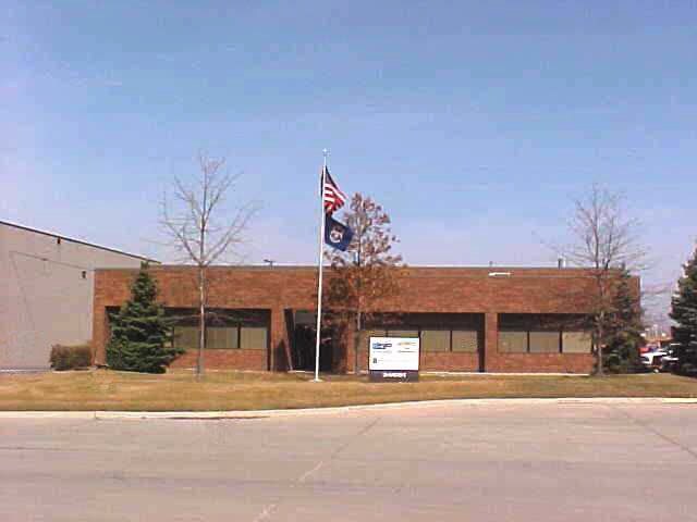

Property Detail
24601 Maplehurst Dr
16-11-01-276-007
50-11-01-276-007 D5 90 SUB MAPLEHURST SUBDIVISION LOT 5
Lightindustrial
Macomb
I-1
Michigan
B and X Area of moderate flood hazard, usually the area between the limits of the 100-year and 500-year floods.
5
2025
1.17 AC
2025
Groesbeck North
240000
Detroit
15,614 SF
Detroit-Warren-Dearborn, MI
NEARBY LISTINGS FOR SALE OR LEASE
DEMOGRAPHICS near 24601 Maplehurst Dr
1 mile
3 mile
5 mile
2025 Total Population
5,034
60,329
178,087
2030 Population
5,231
61,318
180,583
Pop Growth 2025-2030
+ 3.91%
+ 1.64%
+ 1.40%
Average Age
39
40
42
2025 Total Households
1,985
24,544
73,202
HH Growth 2025-2030
+ 3.63%
+ 1.47%
+ 1.45%
Median Household Inc
$58,230
$74,555
$81,440
Avg Household Size
2.50
2.40
2.40
2025 Avg HH Vehicles
2.00
2.00
2.00
Median Home Value
$179,941
$277,909
$285,031
Median Year Built
1991
1990
1987
Nearby Places
Map Layers
Map Styles
 Street
 Aerial
Layers
 Traffic
 Biking
Places
Listings with unknown addresses are not visible on the map
- Restaurants
- Banks
- Shops
- Fitness
- Groceries
PUBLIC TRANSPORTATION
AIRPORT
Windsor International
Drive
Walk
Distance
Windsor International
61 min
37.7 mi
Detroit Metro Wayne County
Drive
Walk
Distance
Detroit Metro Wayne County
64 min
47.2 mi
Nearby Properties
Address
Land Use
TOTAL SIZE
Lot Size
Zoning
Address
Land Use
TOTAL SIZE
Lot Size
Zoning
122.50 AC
RML
Address
Land Use
TOTAL SIZE
Lot Size
Zoning
20,891 SF
289.61 AC
R3
Address
Land Use
TOTAL SIZE
Lot Size
Zoning
404,160 SF
22.52 AC
I-1
Address
Land Use
TOTAL SIZE
Lot Size
Zoning
44.65 AC
RML
Address
Land Use
TOTAL SIZE
Lot Size
Zoning
25.14 AC
RML
Address
Land Use
TOTAL SIZE
Lot Size
Zoning
20.27 AC
RML
Address
Land Use
TOTAL SIZE
Lot Size
Zoning
252,226 SF
52.79 AC
Address
Land Use
TOTAL SIZE
Lot Size
Zoning
26.92 AC
RML
Address
Land Use
TOTAL SIZE
Lot Size
Zoning
670,448 SF
37.23 AC
L-2
Address
Land Use
TOTAL SIZE
Lot Size
Zoning
196,459 SF
19.18 AC
I-1
Address
Land Use
TOTAL SIZE
Lot Size
Zoning
229,878 SF
19.93 AC
C4 MULT
Address
Land Use
TOTAL SIZE
Lot Size
Zoning
42,385 SF
25.55 AC
B-2
Address
Land Use
TOTAL SIZE
Lot Size
Zoning
72,572 SF
10 AC
B-3
Address
Land Use
TOTAL SIZE
Lot Size
Zoning
134,327 SF
10.02 AC
I-1
Address
Land Use
TOTAL SIZE
Lot Size
Zoning
600 SF
18.79 AC
R2L
Address
Land Use
TOTAL SIZE
Lot Size
Zoning
214,201 SF
24.10 AC
B-3
Address
Land Use
TOTAL SIZE
Lot Size
Zoning
87.32 AC
MH
Address
Land Use
TOTAL SIZE
Lot Size
Zoning
115,349 SF
14.39 AC
C3
Address
Land Use
TOTAL SIZE
Lot Size
Zoning
45,864 SF
4.60 AC
C2
Address
Land Use
TOTAL SIZE
Lot Size
Zoning
120,360 SF
10.70 AC
GC
Address
Land Use
TOTAL SIZE
Lot Size
Zoning
149,652 SF
8.04 AC
SP-1
Address
Land Use
TOTAL SIZE
Lot Size
Zoning
99,717 SF
2.14 AC
I-1
Address
Land Use
TOTAL SIZE
Lot Size
Zoning
322,418 SF
8.08 AC
MU
Address
Land Use
TOTAL SIZE
Lot Size
Zoning
252,226 SF
49.16 AC
Address
Land Use
TOTAL SIZE
Lot Size
Zoning
136,474 SF
12.62 AC
I-1
Address
Land Use
TOTAL SIZE
Lot Size
Zoning
98,014 SF
8.69 AC
I-1
Address
Land Use
TOTAL SIZE
Lot Size
Zoning
123,184 SF
10.02 AC
I-1
Address
Land Use
TOTAL SIZE
Lot Size
Zoning
218,662 SF
16.61 AC
M2 GEN
Address
Land Use
TOTAL SIZE
Lot Size
Zoning
138,834 SF
16.46 AC
I-1
Address
Land Use
TOTAL SIZE
Lot Size
Zoning
84,112 SF
8.01 AC
I-1
The World's #1 Commercial Real Estate Marketplace
Connect with us
© 2026 CoStar Group
The information above has been obtained from sources believed reliable. While we do not doubt its accuracy we have not verified it and make no guarantee, warranty or representation about it. It is your responsibility to independently confirm its accuracy and completeness. Any projections, opinions, assumptions, or estimates used are for example only and do not represent the current or future performance of the property. The value of this transaction to you depends on tax and other factors which should be evaluated by your tax, financial, and legal advisors. You and your advisors should conduct a careful, independent investigation of the property to determine to your satisfaction the suitability of the property for your needs.