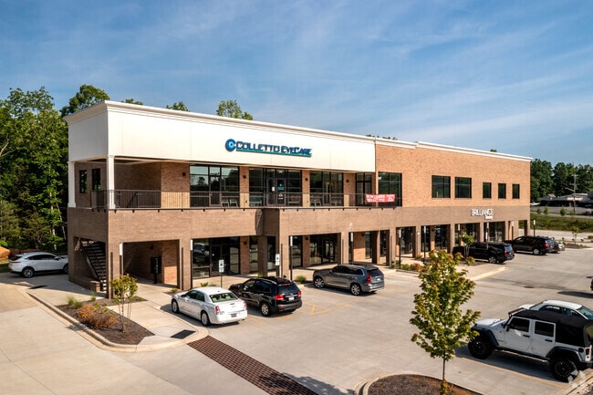
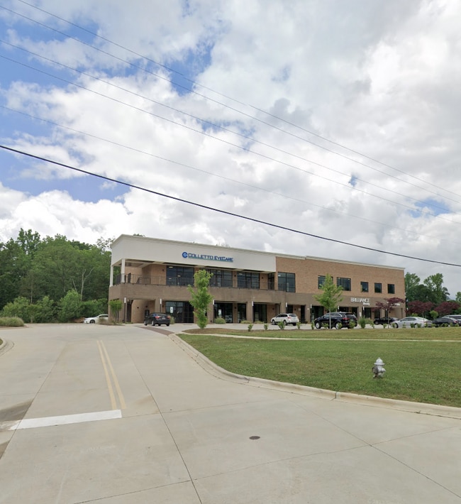
Property Record
247 Mt Gallant Rd E, Rock Hill, SC 29730

Current Lease Availabilities
General Retail LEASE
$20.00 - $24.00 SF/YR
1,200 - 5,600 SF
Property Detail
247 Mt Gallant Rd E
6670101153
4.99 AC / MT GALLANT RD LESS .746AC
Commercialnec
York
AE The base floodplain where base flood elevations are provided. AE Zones are now used on new format FIRMs instead of A1-A30 Zones.
South Carolina
2025
4.24 AC
2025
York County
060901
Charlotte
19,890 SF
Charlotte-Concord-Gastonia, NC-SC
NEARBY LISTINGS FOR SALE OR LEASE
DEMOGRAPHICS near 247 Mt Gallant Rd E
1 mile
3 mile
5 mile
2025 Total Population
3,358
49,244
105,158
2030 Population
3,553
51,850
110,835
Pop Growth 2025-2030
+ 5.81%
+ 5.29%
+ 5.40%
Average Age
38
38
39
2025 Total Households
1,507
20,417
41,754
HH Growth 2025-2030
+ 5.84%
+ 5.61%
+ 5.52%
Median Household Inc
$66,362
$59,768
$68,665
Avg Household Size
2.20
2.30
2.40
2025 Avg HH Vehicles
2.00
2.00
2.00
Median Home Value
$249,350
$302,602
$337,565
Median Year Built
2004
1991
1994
Nearby Places
Map Layers
Map Styles
 Street
 Aerial
Layers
 Traffic
 Biking
Places
Listings with unknown addresses are not visible on the map
- Restaurants
- Banks
- Shops
- Fitness
- Groceries
PUBLIC TRANSPORTATION
AIRPORT
Charlotte/Douglas International
Drive
Walk
Distance
Charlotte/Douglas International
36 min
21.6 mi
Freight Ports
North Charleston Terminal
Drive
Walk
Distance
North Charleston Terminal
199 min
177.8 mi
Nearby Properties
Address
Land Use
TOTAL SIZE
Lot Size
Zoning
Address
Land Use
TOTAL SIZE
Lot Size
Zoning
28,104 SF
11.84 AC
NMU
Address
Land Use
TOTAL SIZE
Lot Size
Zoning
18,192 SF
17.98 AC
MF15
Address
Land Use
TOTAL SIZE
Lot Size
Zoning
13,486 SF
14.27 AC
GC
Address
Land Use
TOTAL SIZE
Lot Size
Zoning
13,556 SF
10.86 AC
MF15
Address
Land Use
TOTAL SIZE
Lot Size
Zoning
216,000 SF
23.16 AC
Address
Land Use
TOTAL SIZE
Lot Size
Zoning
267,338 SF
Address
Land Use
TOTAL SIZE
Lot Size
Zoning
191,882 SF
24.95 AC
IG
Address
Land Use
TOTAL SIZE
Lot Size
Zoning
215.20 AC
UD
Address
Land Use
TOTAL SIZE
Lot Size
Zoning
10,448 SF
12.95 AC
PUD
Address
Land Use
TOTAL SIZE
Lot Size
Zoning
8,512 SF
7.73 AC
MF15
Address
Land Use
TOTAL SIZE
Lot Size
Zoning
24,164 SF
9.50 AC
GC
Address
Land Use
TOTAL SIZE
Lot Size
Zoning
64,338 SF
0.83 AC
Address
Land Use
TOTAL SIZE
Lot Size
Zoning
108,597 SF
14.55 AC
Address
Land Use
TOTAL SIZE
Lot Size
Zoning
252,312 SF
1.25 AC
Address
Land Use
TOTAL SIZE
Lot Size
Zoning
74,880 SF
6.52 AC
Address
Land Use
TOTAL SIZE
Lot Size
Zoning
498,580 SF
51.95 AC
Address
Land Use
TOTAL SIZE
Lot Size
Zoning
28,660 SF
19.95 AC
OI
Address
Land Use
TOTAL SIZE
Lot Size
Zoning
40,532 SF
9.96 AC
SF5
Address
Land Use
TOTAL SIZE
Lot Size
Zoning
163,085 SF
6.84 AC
Address
Land Use
TOTAL SIZE
Lot Size
Zoning
68,486 SF
8.88 AC
IG
Address
Land Use
TOTAL SIZE
Lot Size
Zoning
28,569 SF
0.39 AC
Address
Land Use
TOTAL SIZE
Lot Size
Zoning
Address
Land Use
TOTAL SIZE
Lot Size
Zoning
18,990 SF
0.23 AC
Address
Land Use
TOTAL SIZE
Lot Size
Zoning
45.20 AC
Address
Land Use
TOTAL SIZE
Lot Size
Zoning
29,196 SF
28.01 AC
Address
Land Use
TOTAL SIZE
Lot Size
Zoning
113,490 SF
7 AC
Address
Land Use
TOTAL SIZE
Lot Size
Zoning
851,500 SF
72.70 AC
Address
Land Use
TOTAL SIZE
Lot Size
Zoning
57,670 SF
6.48 AC
IG
Address
Land Use
TOTAL SIZE
Lot Size
Zoning
84,995 SF
5.09 AC
DTWN
Address
Land Use
TOTAL SIZE
Lot Size
Zoning
16,872 SF
19.80 AC
PUD
The World's #1 Commercial Real Estate Marketplace
Connect with us
© 2026 CoStar Group
The information above has been obtained from sources believed reliable. While we do not doubt its accuracy we have not verified it and make no guarantee, warranty or representation about it. It is your responsibility to independently confirm its accuracy and completeness. Any projections, opinions, assumptions, or estimates used are for example only and do not represent the current or future performance of the property. The value of this transaction to you depends on tax and other factors which should be evaluated by your tax, financial, and legal advisors. You and your advisors should conduct a careful, independent investigation of the property to determine to your satisfaction the suitability of the property for your needs.