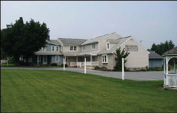
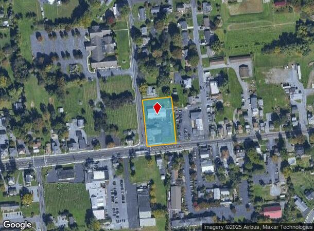
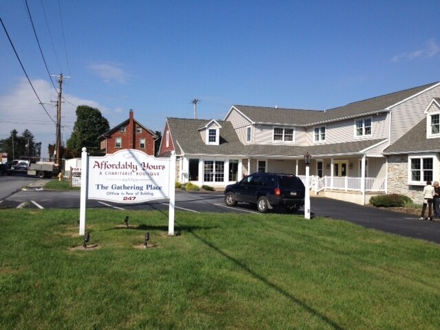
Property Record
247 W Main St, Ephrata, PA 17522
NEARBY LISTINGS FOR SALE OR LEASE
Property Detail
247 W Main St
360-08511-0-0000
J Scott Steffy
Servicestation
247 W MAIN ST
X
Lancaster
42071C0379F
Pennsylvania
2024
1.20 AC
2025
Lancaster County
012301
Philadelphia
6,943 SF
Lancaster, PA
DEMOGRAPHICS near 247 W Main St
1 Mile
3 Mile
5 Mile
2024 Total Population
4,620
16,388
62,319
2029 Population
4,623
16,395
62,482
Pop Growth 2024-2029
+ 0.06%
+ 0.04%
+ 0.26%
Average Age
37
39
41
2024 Total Households
1,596
5,642
23,267
HH Growth 2024-2029
+ 0.06%
+ 0.07%
+ 0.28%
Median Household Inc
$78,414
$88,740
$83,001
Avg Household Size
2.80
2.80
2.60
2024 Avg HH Vehicles
2.00
2.00
2.00
Median Home Value
$312,500
$290,060
$276,174
Median Year Built
1977
1977
1977
Nearby Places
Map Layers
Map Styles
 Street
 Aerial
- Restaurants
- Banks
- Shops
- Fitness
- Groceries
PUBLIC TRANSPORTATION
COMMUTER RAIL
Lancaster (Keystone Service - Amtrak, Pennsylvanian - Amtrak)
DRIVE
WALK
Distance
Lancaster (Keystone Service - Amtrak, Pennsylvanian - Amtrak)
14 min
7.0 mi
Freight Ports
Port of Wilmington, RI
DRIVE
WALK
Distance
Port of Wilmington, RI
87 min
49.5 mi
Nearby Properties
Address
Land Use
TOTAL SIZE
Lot Size
Zoning
Address
Land Use
TOTAL SIZE
Lot Size
Zoning
403,771 SF
106.93 AC
Address
Land Use
TOTAL SIZE
Lot Size
Zoning
2,615,989 SF
147.50 AC
I
Address
Land Use
TOTAL SIZE
Lot Size
Zoning
419,136 SF
34.11 AC
Address
Land Use
TOTAL SIZE
Lot Size
Zoning
333,301 SF
24.15 AC
MU
Address
Land Use
TOTAL SIZE
Lot Size
Zoning
21.41 AC
Address
Land Use
TOTAL SIZE
Lot Size
Zoning
74,841 SF
16.20 AC
R-1
Address
Land Use
TOTAL SIZE
Lot Size
Zoning
111,896 SF
8.30 AC
Address
Land Use
TOTAL SIZE
Lot Size
Zoning
19.29 AC
Address
Land Use
TOTAL SIZE
Lot Size
Zoning
246,116 SF
16.30 AC
R-2
Address
Land Use
TOTAL SIZE
Lot Size
Zoning
109,200 SF
12.97 AC
R-2
Address
Land Use
TOTAL SIZE
Lot Size
Zoning
82,718 SF
7.85 AC
I
Address
Land Use
TOTAL SIZE
Lot Size
Zoning
122,854 SF
11.40 AC
R-2
Address
Land Use
TOTAL SIZE
Lot Size
Zoning
105,946 SF
30.23 AC
I
Address
Land Use
TOTAL SIZE
Lot Size
Zoning
73,648 SF
10.20 AC
R-1
Address
Land Use
TOTAL SIZE
Lot Size
Zoning
155,342 SF
7.38 AC
Address
Land Use
TOTAL SIZE
Lot Size
Zoning
100,645 SF
5.60 AC
I
Address
Land Use
TOTAL SIZE
Lot Size
Zoning
66,600 SF
24.43 AC
B-4
Address
Land Use
TOTAL SIZE
Lot Size
Zoning
118,400 SF
7.90 AC
I
Address
Land Use
TOTAL SIZE
Lot Size
Zoning
48,827 SF
7.60 AC
GC
Address
Land Use
TOTAL SIZE
Lot Size
Zoning
133,788 SF
10.10 AC
I
Address
Land Use
TOTAL SIZE
Lot Size
Zoning
40,425 SF
6.22 AC
GC
Address
Land Use
TOTAL SIZE
Lot Size
Zoning
112,433 SF
14.60 AC
Address
Land Use
TOTAL SIZE
Lot Size
Zoning
86,050 SF
7.06 AC
I
Address
Land Use
TOTAL SIZE
Lot Size
Zoning
96,870 SF
10.98 AC
I
Address
Land Use
TOTAL SIZE
Lot Size
Zoning
106,542 SF
19.30 AC
I
Address
Land Use
TOTAL SIZE
Lot Size
Zoning
96,536 SF
15.10 AC
I
Address
Land Use
TOTAL SIZE
Lot Size
Zoning
56,232 SF
4.45 AC
I
Address
Land Use
TOTAL SIZE
Lot Size
Zoning
70,190 SF
10.28 AC
I
Address
Land Use
TOTAL SIZE
Lot Size
Zoning
102,179 SF
2.80 AC
I
Address
Land Use
TOTAL SIZE
Lot Size
Zoning
58,895 SF
4.70 AC
GC
The World's #1 Commercial Real Estate Marketplace
Connect with us
© 2025 CoStar Group
The information above has been obtained from sources believed reliable. While we do not doubt its accuracy we have not verified it and make no guarantee, warranty or representation about it. It is your responsibility to independently confirm its accuracy and completeness. Any projections, opinions, assumptions, or estimates used are for example only and do not represent the current or future performance of the property. The value of this transaction to you depends on tax and other factors which should be evaluated by your tax, financial, and legal advisors. You and your advisors should conduct a careful, independent investigation of the property to determine to your satisfaction the suitability of the property for your needs.