Property Record
2478 Patterson Rd, Grand Junction, CO 81505
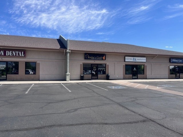
This Property Is For Sale
NEARBY LISTINGS FOR SALE OR LEASE
Property Detail
2478 Patterson Rd
Grand Junction, CO
Patterson Village Square Condominiums
2945-044-17-029
UNIT 26 PATTERSON VILLAGE SQUARE CONDOMINIUM FILING THREE SEC 4 1S 1W FILED RECP NO 2148385 DECL RECD RECP NO 2048132 AS AMENDED RECP NO 2088877 AND THIRD AMEND RECP NO 2145788 MESA CO RECDS & AN UND INT IN COMMON ELEMENTS
Commercialcondominium
Mesa
X
Colorado
08077C0804G
29
2023
0.12 AC
2024
Colorado Northwest Area
000900
Other Market Areas
1,340 SF
DEMOGRAPHICS near 2478 Patterson Rd
1 mile
3 mile
5 mile
2024 Total Population
5,206
42,557
83,024
2029 Population
5,552
44,946
87,366
Pop Growth 2024-2029
+ 6.65%
+ 5.61%
+ 5.23%
Average Age
41
42
42
2024 Total Households
2,308
18,251
34,935
HH Growth 2024-2029
+ 6.67%
+ 5.85%
+ 5.38%
Median Household Inc
$71,730
$64,249
$63,673
Avg Household Size
2.20
2.10
2.20
2024 Avg HH Vehicles
2.00
2.00
2.00
Median Home Value
$359,037
$375,065
$369,945
Median Year Built
2000
1982
1984
Nearby Places
Map Layers
Map Styles
 Street
 Aerial
Transit
 Traffic
 Biking
Places
Listings with unknown addresses are not visible on the map
- Restaurants
- Banks
- Shops
- Fitness
- Groceries
PUBLIC TRANSPORTATION
COMMUTER RAIL
Grand Junction Amtrak Station (California Zephyr - Amtrak)
Drive
Walk
Distance
Grand Junction Amtrak Station (California Zephyr - Amtrak)
6 min
3.0 mi
AIRPORT
Grand Junction Regional
Drive
Walk
Distance
Grand Junction Regional
11 min
5.1 mi
Freight Ports
Port of Long Beach
Drive
Walk
Distance
Port of Long Beach
814 min
787.3 mi
Nearby Properties
Address
Land Use
TOTAL SIZE
Lot Size
Zoning
Address
Land Use
TOTAL SIZE
Lot Size
Zoning
889,724 SF
22.01 AC
PD
Address
Land Use
TOTAL SIZE
Lot Size
Zoning
278,357 SF
29.28 AC
MU
Address
Land Use
TOTAL SIZE
Lot Size
Zoning
482,392 SF
24.70 AC
CSR
Address
Land Use
TOTAL SIZE
Lot Size
Zoning
429,786 SF
16.99 AC
CSR
Address
Land Use
TOTAL SIZE
Lot Size
Zoning
444,676 SF
29.47 AC
CSR
Address
Land Use
TOTAL SIZE
Lot Size
Zoning
181,976 SF
14.80 AC
CSR
Address
Land Use
TOTAL SIZE
Lot Size
Zoning
90,528 SF
6.09 AC
MU
Address
Land Use
TOTAL SIZE
Lot Size
Zoning
206,585 SF
18.98 AC
C-2
Address
Land Use
TOTAL SIZE
Lot Size
Zoning
75,770 SF
82.62 AC
CSR
Address
Land Use
TOTAL SIZE
Lot Size
Zoning
130,260 SF
0.20 AC
C-1
Address
Land Use
TOTAL SIZE
Lot Size
Zoning
399,553 SF
C-1
Address
Land Use
TOTAL SIZE
Lot Size
Zoning
127,269 SF
3.21 AC
B-2
Address
Land Use
TOTAL SIZE
Lot Size
Zoning
113,925 SF
0.16 AC
PD
Address
Land Use
TOTAL SIZE
Lot Size
Zoning
82,986 SF
4.20 AC
PD
Address
Land Use
TOTAL SIZE
Lot Size
Zoning
94,818 SF
19.78 AC
RSF-4
Address
Land Use
TOTAL SIZE
Lot Size
Zoning
69,390 SF
0.14 AC
C-1
Address
Land Use
TOTAL SIZE
Lot Size
Zoning
93,531 SF
5.19 AC
Address
Land Use
TOTAL SIZE
Lot Size
Zoning
94,639 SF
0.16 AC
C-1
Address
Land Use
TOTAL SIZE
Lot Size
Zoning
97,602 SF
23.51 AC
RSF-4
Address
Land Use
TOTAL SIZE
Lot Size
Zoning
126,114 SF
13.75 AC
B-2
Address
Land Use
TOTAL SIZE
Lot Size
Zoning
66,178 SF
2.02 AC
PD
Address
Land Use
TOTAL SIZE
Lot Size
Zoning
86,946 SF
5.52 AC
C-1
Address
Land Use
TOTAL SIZE
Lot Size
Zoning
83,518 SF
1.45 AC
CSR
Address
Land Use
TOTAL SIZE
Lot Size
Zoning
70,394 SF
6.19 AC
PD
Address
Land Use
TOTAL SIZE
Lot Size
Zoning
215,583 SF
20.40 AC
C-1
Address
Land Use
TOTAL SIZE
Lot Size
Zoning
85,303 SF
8.45 AC
C-2
Address
Land Use
TOTAL SIZE
Lot Size
Zoning
79,905 SF
8.43 AC
PD
Address
Land Use
TOTAL SIZE
Lot Size
Zoning
87,806 SF
0.11 AC
Address
Land Use
TOTAL SIZE
Lot Size
Zoning
43,390 SF
3.80 AC
The World's #1 Commercial Real Estate Marketplace
Connect with us
© 2026 CoStar Group
The information above has been obtained from sources believed reliable. While we do not doubt its accuracy we have not verified it and make no guarantee, warranty or representation about it. It is your responsibility to independently confirm its accuracy and completeness. Any projections, opinions, assumptions, or estimates used are for example only and do not represent the current or future performance of the property. The value of this transaction to you depends on tax and other factors which should be evaluated by your tax, financial, and legal advisors. You and your advisors should conduct a careful, independent investigation of the property to determine to your satisfaction the suitability of the property for your needs.