Property Record
249 Progress Dr, Manchester, CT 06042
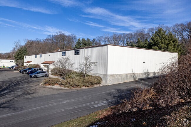

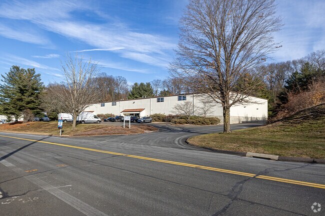
Property Detail
249 Progress Dr
MANC-000105-004670-000249
Capitol
Industrialgeneral
Connecticut
IND
249
B and X Area of moderate flood hazard, usually the area between the limits of the 100-year and 500-year floods.
3.73 AC
2025
Manchester
2025
Hartford
514101
Hartford-West Hartford-East Hartford, CT
30,250 SF
NEARBY LISTINGS FOR SALE OR LEASE
DEMOGRAPHICS near 249 Progress Dr
1 mile
3 mile
5 mile
2024 Total Population
7,547
59,905
121,206
2029 Population
7,649
61,000
123,646
Pop Growth 2024-2029
+ 1.35%
+ 1.83%
+ 2.01%
Average Age
42
41
41
2024 Total Households
3,195
25,314
51,073
HH Growth 2024-2029
+ 1.28%
+ 1.88%
+ 2.07%
Median Household Inc
$84,819
$90,447
$93,269
Avg Household Size
2.30
2.30
2.30
2024 Avg HH Vehicles
2.00
2.00
2.00
Median Home Value
$261,448
$271,110
$290,133
Median Year Built
1971
1965
1970
Nearby Places
Map Layers
Map Styles
 Street
 Aerial
Transit
 Traffic
 Biking
Places
Listings with unknown addresses are not visible on the map
- Restaurants
- Banks
- Shops
- Fitness
- Groceries
PUBLIC TRANSPORTATION
AIRPORT
Bradley International
Drive
Walk
Distance
Bradley International
35 min
21.2 mi
Freight Ports
Port of New Haven
Drive
Walk
Distance
Port of New Haven
66 min
48.8 mi
SALE & LEASE HISTORY
LISTING DATE
SALE/LEASE

Mar 25, 2022
For Lease
Nearby Properties
Address
Land Use
TOTAL SIZE
Lot Size
Zoning
Address
Land Use
TOTAL SIZE
Lot Size
Zoning
75.65 AC
PDZ GE
Address
Land Use
TOTAL SIZE
Lot Size
Zoning
12.54 AC
Address
Land Use
TOTAL SIZE
Lot Size
Zoning
467,349 SF
13.83 AC
CUD
Address
Land Use
TOTAL SIZE
Lot Size
Zoning
29.87 AC
PDZ GE
Address
Land Use
TOTAL SIZE
Lot Size
Zoning
20,384 SF
40 AC
PRD
Address
Land Use
TOTAL SIZE
Lot Size
Zoning
28,608 SF
25.37 AC
CUD
Address
Land Use
TOTAL SIZE
Lot Size
Zoning
43.60 AC
PRD
Address
Land Use
TOTAL SIZE
Lot Size
Zoning
12,068 SF
21.79 AC
CUD
Address
Land Use
TOTAL SIZE
Lot Size
Zoning
29,744 SF
29.50 AC
PRD
Address
Land Use
TOTAL SIZE
Lot Size
Zoning
24.02 AC
COMMER
Address
Land Use
TOTAL SIZE
Lot Size
Zoning
175,936 SF
18.28 AC
GD
Address
Land Use
TOTAL SIZE
Lot Size
Zoning
26.65 AC
GB
Address
Land Use
TOTAL SIZE
Lot Size
Zoning
53.59 AC
RA
Address
Land Use
TOTAL SIZE
Lot Size
Zoning
219,479 SF
9.32 AC
H
Address
Land Use
TOTAL SIZE
Lot Size
Zoning
149,322 SF
16.76 AC
A30
Address
Land Use
TOTAL SIZE
Lot Size
Zoning
111,800 SF
5.80 AC
GD
Address
Land Use
TOTAL SIZE
Lot Size
Zoning
19.60 AC
GB
Address
Land Use
TOTAL SIZE
Lot Size
Zoning
22.12 AC
FBZ
Address
Land Use
TOTAL SIZE
Lot Size
Zoning
68,988 SF
9.17 AC
GB
Address
Land Use
TOTAL SIZE
Lot Size
Zoning
43,394 SF
35 AC
A30
Address
Land Use
TOTAL SIZE
Lot Size
Zoning
6.38 AC
CBD
Address
Land Use
TOTAL SIZE
Lot Size
Zoning
11.14 AC
CD
Address
Land Use
TOTAL SIZE
Lot Size
Zoning
27.05 AC
COMMER
Address
Land Use
TOTAL SIZE
Lot Size
Zoning
81,412 SF
9.20 AC
GD
Address
Land Use
TOTAL SIZE
Lot Size
Zoning
79,198 SF
10.47 AC
RA
Address
Land Use
TOTAL SIZE
Lot Size
Zoning
195,772 SF
3.17 AC
H
Address
Land Use
TOTAL SIZE
Lot Size
Zoning
13.01 AC
B5
Address
Land Use
TOTAL SIZE
Lot Size
Zoning
127,089 SF
12.89 AC
GD
Address
Land Use
TOTAL SIZE
Lot Size
Zoning
7.11 AC
CUD
Address
Land Use
TOTAL SIZE
Lot Size
Zoning
106,380 SF
12.55 AC
CUD
The World's #1 Commercial Real Estate Marketplace
Connect with us
© 2026 CoStar Group
The information above has been obtained from sources believed reliable. While we do not doubt its accuracy we have not verified it and make no guarantee, warranty or representation about it. It is your responsibility to independently confirm its accuracy and completeness. Any projections, opinions, assumptions, or estimates used are for example only and do not represent the current or future performance of the property. The value of this transaction to you depends on tax and other factors which should be evaluated by your tax, financial, and legal advisors. You and your advisors should conduct a careful, independent investigation of the property to determine to your satisfaction the suitability of the property for your needs.