Property Record
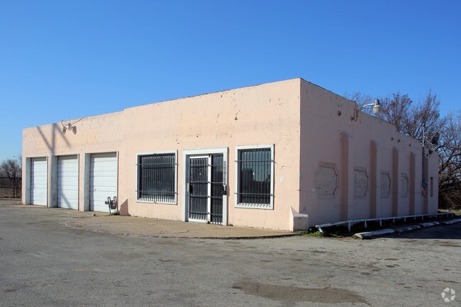
2494 N Lewis Ave, Tulsa, OK 74110


This Property Is For Sale
NEARBY LISTINGS FOR SALE OR LEASE
Property Detail
2494 N Lewis Ave
90330-03-30-18340
Unplatted
Autorepair
N/2 NE NE NE LESS E40 & LESS N40 & LESS W205 E245 S125 THEREOF SEC 30 20 13
X
Tulsa
40143C0229L
Oklahoma
2025
3.51 AC
2025
Northwest Tulsa
000500
Tulsa
2,700 SF
Tulsa, OK
DEMOGRAPHICS near 2494 N Lewis Ave
1 Mile
3 Mile
5 Mile
2024 Total Population
7,755
69,220
141,866
2029 Population
8,169
72,788
148,353
Pop Growth 2024-2029
+ 5.34%
+ 5.15%
+ 4.57%
Average Age
35
36
38
2024 Total Households
2,825
25,330
57,871
HH Growth 2024-2029
+ 5.45%
+ 5.51%
+ 4.77%
Median Household Inc
$28,490
$34,180
$43,954
Avg Household Size
2.60
2.50
2.30
2024 Avg HH Vehicles
2.00
2.00
2.00
Median Home Value
$73,647
$74,830
$119,045
Median Year Built
1958
1956
1956
Nearby Places
Map Layers
Map Styles
 Street
 Aerial
- Restaurants
- Banks
- Shops
- Fitness
- Groceries
PUBLIC TRANSPORTATION
AIRPORT
Tulsa International
DRIVE
WALK
Distance
Tulsa International
10 min
5.7 mi
Freight Ports
Tulsa Port Of Catoosa
DRIVE
WALK
Distance
Tulsa Port Of Catoosa
20 min
13.8 mi
Nearby Properties
Address
Land Use
TOTAL SIZE
Lot Size
Zoning
Address
Land Use
TOTAL SIZE
Lot Size
Zoning
1,673,798 SF
90.26 AC
NCU
Address
Land Use
TOTAL SIZE
Lot Size
Zoning
10,736 SF
101.62 AC
Address
Land Use
TOTAL SIZE
Lot Size
Zoning
87,606 SF
8.25 AC
CBD
Address
Land Use
TOTAL SIZE
Lot Size
Zoning
92,407 SF
6.02 AC
CS
Address
Land Use
TOTAL SIZE
Lot Size
Zoning
175,176 SF
1.57 AC
RM2
Address
Land Use
TOTAL SIZE
Lot Size
Zoning
230,620 SF
16.72 AC
RM2
Address
Land Use
TOTAL SIZE
Lot Size
Zoning
144,570 SF
44.59 AC
RM2
Address
Land Use
TOTAL SIZE
Lot Size
Zoning
94,115 SF
15.18 AC
IM
Address
Land Use
TOTAL SIZE
Lot Size
Zoning
161,670 SF
8.57 AC
IL
Address
Land Use
TOTAL SIZE
Lot Size
Zoning
106,579 SF
6.76 AC
RM1
Address
Land Use
TOTAL SIZE
Lot Size
Zoning
53,337 SF
3.34 AC
FBC
Address
Land Use
TOTAL SIZE
Lot Size
Zoning
60,320 SF
5.23 AC
NCU
Address
Land Use
TOTAL SIZE
Lot Size
Zoning
163,321 SF
10.74 AC
RS3
Address
Land Use
TOTAL SIZE
Lot Size
Zoning
195,492 SF
17.11 AC
RM1
Address
Land Use
TOTAL SIZE
Lot Size
Zoning
54,684 SF
0.96 AC
CBD
Address
Land Use
TOTAL SIZE
Lot Size
Zoning
333,000 SF
1.32 AC
CBD
Address
Land Use
TOTAL SIZE
Lot Size
Zoning
56,476 SF
2.89 AC
RM2
Address
Land Use
TOTAL SIZE
Lot Size
Zoning
38,908 SF
2.39 AC
IM
Address
Land Use
TOTAL SIZE
Lot Size
Zoning
67,334 SF
0.84 AC
IL
Address
Land Use
TOTAL SIZE
Lot Size
Zoning
121,518 SF
8.52 AC
IM
Address
Land Use
TOTAL SIZE
Lot Size
Zoning
40,433 SF
2.92 AC
IL
Address
Land Use
TOTAL SIZE
Lot Size
Zoning
109,438 SF
1.77 AC
RM3
Address
Land Use
TOTAL SIZE
Lot Size
Zoning
36,962 SF
1.23 AC
CH
Address
Land Use
TOTAL SIZE
Lot Size
Zoning
8,547 SF
0.32 AC
CBD
Address
Land Use
TOTAL SIZE
Lot Size
Zoning
519,146 SF
2.07 AC
CBD
Address
Land Use
TOTAL SIZE
Lot Size
Zoning
99,468 SF
1.10 AC
CBD
Address
Land Use
TOTAL SIZE
Lot Size
Zoning
29,584 SF
2.99 AC
IM
Address
Land Use
TOTAL SIZE
Lot Size
Zoning
41,874 SF
35.70 AC
RS3
Address
Land Use
TOTAL SIZE
Lot Size
Zoning
592,475 SF
4.38 AC
CH
The World's #1 Commercial Real Estate Marketplace
Connect with us
© 2025 CoStar Group
The information above has been obtained from sources believed reliable. While we do not doubt its accuracy we have not verified it and make no guarantee, warranty or representation about it. It is your responsibility to independently confirm its accuracy and completeness. Any projections, opinions, assumptions, or estimates used are for example only and do not represent the current or future performance of the property. The value of this transaction to you depends on tax and other factors which should be evaluated by your tax, financial, and legal advisors. You and your advisors should conduct a careful, independent investigation of the property to determine to your satisfaction the suitability of the property for your needs.