Property Record
250 Adriatic Pkwy, Mckinney, TX 75072
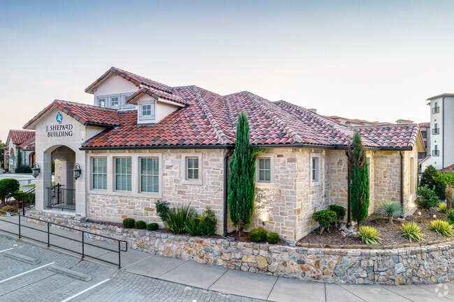


Property Detail
250 Adriatic Pkwy
R-10832-00F-0000-1
ADRIATICA VILLAGE CENTER, BLDG F, 9.0 % CMN INT
Commercialcondominium
COLLIN
B and X Area of moderate flood hazard, usually the area between the limits of the 100-year and 500-year floods.
Texas
2025
3.30 AC
2025
Allen/McKinney
030531
Dallas/Ft Worth
3,560 SF
Dallas-Fort Worth-Arlington, TX
NEARBY LISTINGS FOR SALE OR LEASE
DEMOGRAPHICS near 250 Adriatic Pkwy
1 mile
3 mile
5 mile
2025 Total Population
12,542
122,870
279,662
2030 Population
14,260
139,790
320,280
Pop Growth 2025-2030
+ 13.70%
+ 13.77%
+ 14.52%
Average Age
41
38
37
2025 Total Households
4,528
41,313
94,772
HH Growth 2025-2030
+ 13.78%
+ 14.00%
+ 14.74%
Median Household Inc
$166,178
$145,639
$140,808
Avg Household Size
2.70
2.90
2.90
2025 Avg HH Vehicles
2.00
2.00
2.00
Median Home Value
$698,974
$552,649
$603,013
Median Year Built
2005
2007
2010
Nearby Places
Map Layers
Map Styles
 Street
 Aerial
Transit
 Traffic
 Biking
Places
Listings with unknown addresses are not visible on the map
- Restaurants
- Banks
- Shops
- Fitness
- Groceries
PUBLIC TRANSPORTATION
AIRPORT
Dallas Love Field
Drive
Walk
Distance
Dallas Love Field
46 min
32.2 mi
Dallas-Fort Worth International
Drive
Walk
Distance
Dallas-Fort Worth International
43 min
33.0 mi
Nearby Properties
Address
Land Use
TOTAL SIZE
Lot Size
Zoning
Address
Land Use
TOTAL SIZE
Lot Size
Zoning
469,170 SF
56.84 AC
Address
Land Use
TOTAL SIZE
Lot Size
Zoning
691,265 SF
53.52 AC
Address
Land Use
TOTAL SIZE
Lot Size
Zoning
256,445 SF
10.42 AC
Address
Land Use
TOTAL SIZE
Lot Size
Zoning
585,170 SF
18.69 AC
MF RG-18
Address
Land Use
TOTAL SIZE
Lot Size
Zoning
518,353 SF
28.51 AC
MF-M
Address
Land Use
TOTAL SIZE
Lot Size
Zoning
398,732 SF
25.88 AC
MF-M
Address
Land Use
TOTAL SIZE
Lot Size
Zoning
291,577 SF
69.24 AC
APTTOWNH
Address
Land Use
TOTAL SIZE
Lot Size
Zoning
505,541 SF
19.78 AC
SFR
Address
Land Use
TOTAL SIZE
Lot Size
Zoning
274,184 SF
20.34 AC
COMM
Address
Land Use
TOTAL SIZE
Lot Size
Zoning
345,998 SF
17.81 AC
MF-M
Address
Land Use
TOTAL SIZE
Lot Size
Zoning
407,094 SF
15.04 AC
MF RG-18
Address
Land Use
TOTAL SIZE
Lot Size
Zoning
300,789 SF
43.28 AC
Address
Land Use
TOTAL SIZE
Lot Size
Zoning
329,086 SF
13.89 AC
MF-M
Address
Land Use
TOTAL SIZE
Lot Size
Zoning
301,764 SF
20.88 AC
MF
Address
Land Use
TOTAL SIZE
Lot Size
Zoning
282,528 SF
5.14 AC
MF-R
Address
Land Use
TOTAL SIZE
Lot Size
Zoning
264,070 SF
15.74 AC
MF-M
Address
Land Use
TOTAL SIZE
Lot Size
Zoning
197,115 SF
10.37 AC
MF-M
Address
Land Use
TOTAL SIZE
Lot Size
Zoning
243,827 SF
13.23 AC
MF
Address
Land Use
TOTAL SIZE
Lot Size
Zoning
201,902 SF
11.22 AC
MF-M
Address
Land Use
TOTAL SIZE
Lot Size
Zoning
185,434 SF
13.70 AC
MF-M
Address
Land Use
TOTAL SIZE
Lot Size
Zoning
217,303 SF
9.01 AC
COMM
Address
Land Use
TOTAL SIZE
Lot Size
Zoning
216,591 SF
33.51 AC
Address
Land Use
TOTAL SIZE
Lot Size
Zoning
168,422 SF
17.11 AC
PD
Address
Land Use
TOTAL SIZE
Lot Size
Zoning
224,254 SF
21.01 AC
SFR
Address
Land Use
TOTAL SIZE
Lot Size
Zoning
118,608 SF
5.24 AC
Address
Land Use
TOTAL SIZE
Lot Size
Zoning
1,025,743 SF
126.16 AC
Address
Land Use
TOTAL SIZE
Lot Size
Zoning
98,872 SF
10.77 AC
Address
Land Use
TOTAL SIZE
Lot Size
Zoning
105,321 SF
12.29 AC
Address
Land Use
TOTAL SIZE
Lot Size
Zoning
126,334 SF
26.04 AC
Address
Land Use
TOTAL SIZE
Lot Size
Zoning
113,730 SF
The World's #1 Commercial Real Estate Marketplace
Connect with us
© 2026 CoStar Group
The information above has been obtained from sources believed reliable. While we do not doubt its accuracy we have not verified it and make no guarantee, warranty or representation about it. It is your responsibility to independently confirm its accuracy and completeness. Any projections, opinions, assumptions, or estimates used are for example only and do not represent the current or future performance of the property. The value of this transaction to you depends on tax and other factors which should be evaluated by your tax, financial, and legal advisors. You and your advisors should conduct a careful, independent investigation of the property to determine to your satisfaction the suitability of the property for your needs.