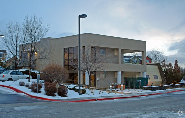
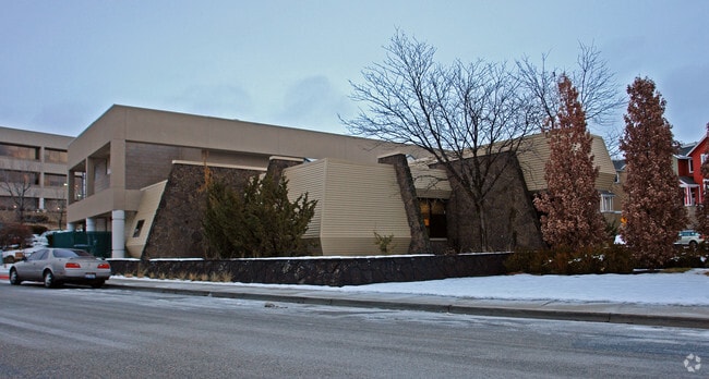
Property Record
2501 N Bogus Basin Rd, Boise, ID 83702
NEARBY LISTINGS FOR SALE OR LEASE
Property Detail
2501 N Bogus Basin Rd
S0634244292
RECORD SUR #8078
Commercialbuilding
Ada
X
Idaho
16001C0189H
0.42 AC
2024
North Ada County
2025
Boise City/Nampa
000202
Boise City, ID
10,790 SF
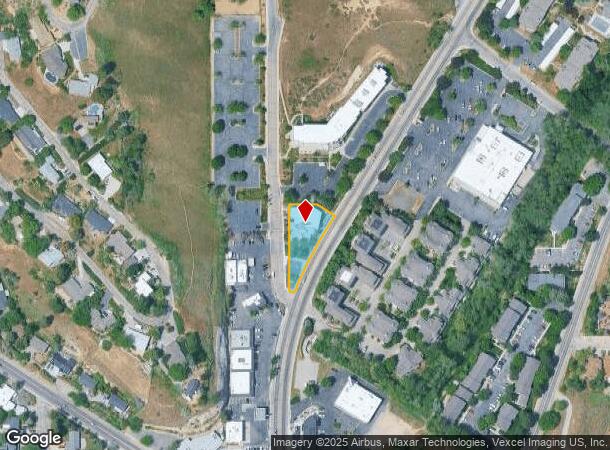
DEMOGRAPHICS near 2501 N Bogus Basin Rd
1 Mile
3 Mile
5 Mile
2024 Total Population
11,068
68,211
172,099
2029 Population
12,491
77,556
194,952
Pop Growth 2024-2029
+ 12.86%
+ 13.70%
+ 13.28%
Average Age
42
40
40
2024 Total Households
4,713
30,699
75,787
HH Growth 2024-2029
+ 13.11%
+ 14.23%
+ 13.68%
Median Household Inc
$98,129
$64,336
$63,881
Avg Household Size
2.30
2.10
2.20
2024 Avg HH Vehicles
2.00
2.00
2.00
Median Home Value
$701,043
$569,548
$455,306
Median Year Built
1967
1979
1982
Nearby Places
Map Layers
Map Styles
 Street
 Aerial
- Restaurants
- Banks
- Shops
- Fitness
- Groceries
PUBLIC TRANSPORTATION
AIRPORT
Boise Air Trml/Gowen Field
DRIVE
WALK
Distance
Boise Air Trml/Gowen Field
21 min
8.7 mi
Nearby Properties
Address
Land Use
TOTAL SIZE
Lot Size
Zoning
Address
Land Use
TOTAL SIZE
Lot Size
Zoning
369,584 SF
1 AC
ZC-259
Address
Land Use
TOTAL SIZE
Lot Size
Zoning
635,403 SF
23.42 AC
ZC-243
Address
Land Use
TOTAL SIZE
Lot Size
Zoning
434,370 SF
0.56 AC
ZC-259
Address
Land Use
TOTAL SIZE
Lot Size
Zoning
129,663 SF
0.92 AC
ZC-259
Address
Land Use
TOTAL SIZE
Lot Size
Zoning
240,481 SF
1.79 AC
ZC-264
Address
Land Use
TOTAL SIZE
Lot Size
Zoning
13.90 AC
R-2
Address
Land Use
TOTAL SIZE
Lot Size
Zoning
4.02 AC
C-2/DA
Address
Land Use
TOTAL SIZE
Lot Size
Zoning
279,694 SF
2.09 AC
ZC-264
Address
Land Use
TOTAL SIZE
Lot Size
Zoning
413,253 SF
3.33 AC
ZC-260
Address
Land Use
TOTAL SIZE
Lot Size
Zoning
402,504 SF
5.78 AC
ZC-259
Address
Land Use
TOTAL SIZE
Lot Size
Zoning
334,334 SF
3.21 AC
ZC-259
Address
Land Use
TOTAL SIZE
Lot Size
Zoning
156,000 SF
4.57 AC
ZC-241
Address
Land Use
TOTAL SIZE
Lot Size
Zoning
204,396 SF
0.82 AC
ZC-261
Address
Land Use
TOTAL SIZE
Lot Size
Zoning
366,126 SF
0.82 AC
ZC-259
Address
Land Use
TOTAL SIZE
Lot Size
Zoning
223,171 SF
0.85 AC
ZC-264
Address
Land Use
TOTAL SIZE
Lot Size
Zoning
359,820 SF
1.79 AC
ZC-259
Address
Land Use
TOTAL SIZE
Lot Size
Zoning
459,218 SF
1.79 AC
ZC-241
Address
Land Use
TOTAL SIZE
Lot Size
Zoning
159,859 SF
0.80 AC
ZC-264
Address
Land Use
TOTAL SIZE
Lot Size
Zoning
245,000 SF
12.28 AC
R-2
Address
Land Use
TOTAL SIZE
Lot Size
Zoning
205,522 SF
0.82 AC
ZC-259
Address
Land Use
TOTAL SIZE
Lot Size
Zoning
276,099 SF
8.70 AC
ZC-261
Address
Land Use
TOTAL SIZE
Lot Size
Zoning
216,371 SF
0.78 AC
ZC-261
Address
Land Use
TOTAL SIZE
Lot Size
Zoning
151,285 SF
9.54 AC
R-1C
Address
Land Use
TOTAL SIZE
Lot Size
Zoning
189,100 SF
0.60 AC
ZC-259
Address
Land Use
TOTAL SIZE
Lot Size
Zoning
222,379 SF
1.37 AC
M
Address
Land Use
TOTAL SIZE
Lot Size
Zoning
182,950 SF
0.41 AC
ZC-259
Address
Land Use
TOTAL SIZE
Lot Size
Zoning
96,969 SF
2 AC
ZC-261
Address
Land Use
TOTAL SIZE
Lot Size
Zoning
211,039 SF
12.21 AC
ZC-243
Address
Land Use
TOTAL SIZE
Lot Size
Zoning
259,231 SF
1.72 AC
ZC-259
Address
Land Use
TOTAL SIZE
Lot Size
Zoning
247,435 SF
2.90 AC
ZC-261
The World's #1 Commercial Real Estate Marketplace
Connect with us
© 2025 CoStar Group
The information above has been obtained from sources believed reliable. While we do not doubt its accuracy we have not verified it and make no guarantee, warranty or representation about it. It is your responsibility to independently confirm its accuracy and completeness. Any projections, opinions, assumptions, or estimates used are for example only and do not represent the current or future performance of the property. The value of this transaction to you depends on tax and other factors which should be evaluated by your tax, financial, and legal advisors. You and your advisors should conduct a careful, independent investigation of the property to determine to your satisfaction the suitability of the property for your needs.