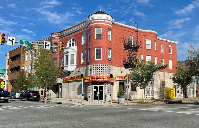
Property Record
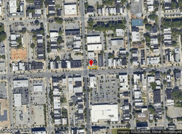
2501 N Charles St, Baltimore, MD 21218
NEARBY LISTINGS FOR SALE OR LEASE
-
-
-
-
-
-
-
-
-
-
-
-
-
-
-
-
-
-
-
-
-
-
-
-
-
-
-
-
-
No Photo
-
View all Baltimore listings for lease on LoopNet.com
Property Detail
2501 N Charles St
Baltimore-Columbia-Towson, MD
Sec 08 Ward 21
3831-022
18X90
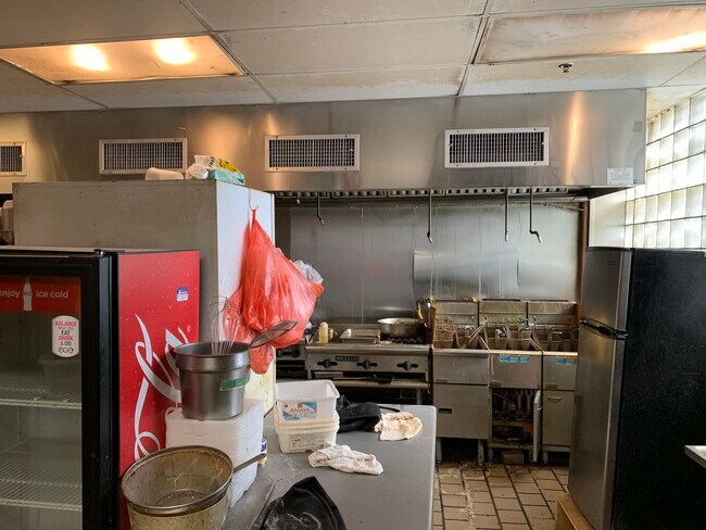
Restaurantbuilding
Baltimore City
X
Maryland
2400100405G
22
2024
0.04 AC
2025
Charles Village
120600
Baltimore
5,504 SF
DEMOGRAPHICS near 2501 N Charles St
1 Mile
3 Mile
5 Mile
2024 Total Population
37,026
294,623
548,678
2029 Population
35,650
288,288
530,591
Pop Growth 2024-2029
(3.72%)
(2.15%)
(3.30%)
Average Age
36
39
39
2024 Total Households
17,589
131,154
236,254
HH Growth 2024-2029
(3.92%)
(2.54%)
(3.56%)
Median Household Inc
$54,199
$52,763
$56,708
Avg Household Size
1.90
2.10
2.20
2024 Avg HH Vehicles
1.00
1.00
1.00
Median Home Value
$242,134
$197,528
$205,128
Median Year Built
1947
1948
1949
Nearby Places
Map Layers
Map Styles
 Street
 Aerial
- Restaurants
- Banks
- Shops
- Fitness
- Groceries
PUBLIC TRANSPORTATION
TRANSIT/SUBWAY
North Avenue (Hunt Valley & BWI Marshall - Maryland Transit Administration Light Rail (Baltimore Light Rail), Timonium & Cromwell - Maryland Transit Administration Light Rail (Baltimore Light Rail))
DRIVE
WALK
Distance
North Avenue (Hunt Valley & BWI Marshall - Maryland Transit Administration Light Rail (Baltimore Light Rail), Timonium & Cromwell - Maryland Transit Administration Light Rail (Baltimore Light Rail))
2 min
16 min
0.9 mi
University Of Baltimore/Mount Royal (Hunt Valley & BWI Marshall - Maryland Transit Administration Light Rail (Baltimore Light Rail), Penn Station & Camden Yards - Maryland Transit Administration Light Rail (Baltimore Light Rail), Timonium & Cromwell - Maryland Transit Administration Light Rail (Baltimore Light Rail))
DRIVE
WALK
Distance
University Of Baltimore/Mount Royal (Hunt Valley & BWI Marshall - Maryland Transit Administration Light Rail (Baltimore Light Rail), Penn Station & Camden Yards - Maryland Transit Administration Light Rail (Baltimore Light Rail), Timonium & Cromwell - Maryland Transit Administration Light Rail (Baltimore Light Rail))
3 min
20 min
1.0 mi
COMMUTER RAIL
Penn Station (PENN - WASHINGTON - Maryland Area Regional Commuter Trains (The MARC), Penn Line - Maryland Area Regional Commuter Trains (The MARC), Penn Station & Camden Yards - Maryland Area Regional Commuter Trains (The MARC))
DRIVE
WALK
Distance
Penn Station (PENN - WASHINGTON - Maryland Area Regional Commuter Trains (The MARC), Penn Line - Maryland Area Regional Commuter Trains (The MARC), Penn Station & Camden Yards - Maryland Area Regional Commuter Trains (The MARC))
2 min
15 min
0.8 mi
Camden Station (CAMDEN - WASHINGTON - Maryland Area Regional Commuter Trains (The MARC), Camden Line - Maryland Area Regional Commuter Trains (The MARC))
DRIVE
WALK
Distance
Camden Station (CAMDEN - WASHINGTON - Maryland Area Regional Commuter Trains (The MARC), Camden Line - Maryland Area Regional Commuter Trains (The MARC))
8 min
2.8 mi
AIRPORT
Baltimore/Washington International Thurgood Marshall
DRIVE
WALK
Distance
Baltimore/Washington International Thurgood Marshall
23 min
12.1 mi
Freight Ports
Port of Baltimore
DRIVE
WALK
Distance
Port of Baltimore
14 min
4.7 mi
SALE & LEASE HISTORY
LISTING DATE
SALE/LEASE

Jan 14, 2021
For Sale
Dec 02, 2024
For Lease
Aug 01, 2018
For Sale
Nearby Properties
Address
Land Use
TOTAL SIZE
Lot Size
Zoning
Address
Land Use
TOTAL SIZE
Lot Size
Zoning
1,595,200 SF
20.36 AC
H
Address
Land Use
TOTAL SIZE
Lot Size
Zoning
1,871,691 SF
6.77 AC
C-5DC
Address
Land Use
TOTAL SIZE
Lot Size
Zoning
1,632,000 SF
106.32 AC
EC-2
Address
Land Use
TOTAL SIZE
Lot Size
Zoning
712,573 SF
1.32 AC
C-5DC
Address
Land Use
TOTAL SIZE
Lot Size
Zoning
20.26 AC
C-5DC
Address
Land Use
TOTAL SIZE
Lot Size
Zoning
21.27 AC
C-5DC
Address
Land Use
TOTAL SIZE
Lot Size
Zoning
739,000 SF
2.79 AC
C-5DC
Address
Land Use
TOTAL SIZE
Lot Size
Zoning
3.89 AC
C-5DC
Address
Land Use
TOTAL SIZE
Lot Size
Zoning
830,720 SF
1.90 AC
I-MU
Address
Land Use
TOTAL SIZE
Lot Size
Zoning
21,312 SF
54.36 AC
EC-2
Address
Land Use
TOTAL SIZE
Lot Size
Zoning
400,000 SF
13.98 AC
0B051
Address
Land Use
TOTAL SIZE
Lot Size
Zoning
1,228,117 SF
9.43 AC
C-2
Address
Land Use
TOTAL SIZE
Lot Size
Zoning
256,816 SF
1.27 AC
EC-2
Address
Land Use
TOTAL SIZE
Lot Size
Zoning
654,224 SF
14.98 AC
C-5DC
Address
Land Use
TOTAL SIZE
Lot Size
Zoning
833,702 SF
1.74 AC
C-5DC
Address
Land Use
TOTAL SIZE
Lot Size
Zoning
911,487 SF
5.27 AC
C-5DC
Address
Land Use
TOTAL SIZE
Lot Size
Zoning
381,152 SF
3.46 AC
C-5DC
Address
Land Use
TOTAL SIZE
Lot Size
Zoning
2.61 AC
C-5DE
Address
Land Use
TOTAL SIZE
Lot Size
Zoning
236,614 SF
1.20 AC
BSC
Address
Land Use
TOTAL SIZE
Lot Size
Zoning
24,993 SF
66.85 AC
EC-2
Address
Land Use
TOTAL SIZE
Lot Size
Zoning
241,576 SF
6.13 AC
H
Address
Land Use
TOTAL SIZE
Lot Size
Zoning
599,187 SF
30.14 AC
EC-2
Address
Land Use
TOTAL SIZE
Lot Size
Zoning
199,435 SF
1.19 AC
BSC
Address
Land Use
TOTAL SIZE
Lot Size
Zoning
289,515 SF
1.10 AC
BSC
Address
Land Use
TOTAL SIZE
Lot Size
Zoning
10,386 SF
15.01 AC
C-5IH
Address
Land Use
TOTAL SIZE
Lot Size
Zoning
334,715 SF
1.77 AC
H
Address
Land Use
TOTAL SIZE
Lot Size
Zoning
656,306 SF
1.10 AC
C-5DC
Address
Land Use
TOTAL SIZE
Lot Size
Zoning
579,351 SF
0.96 AC
C-5DC
Address
Land Use
TOTAL SIZE
Lot Size
Zoning
189,700 SF
0.71 AC
TOD-4
Address
Land Use
TOTAL SIZE
Lot Size
Zoning
538,988 SF
8.40 AC
I-MU
The World's #1 Commercial Real Estate Marketplace
Connect with us
© 2025 CoStar Group
The information above has been obtained from sources believed reliable. While we do not doubt its accuracy we have not verified it and make no guarantee, warranty or representation about it. It is your responsibility to independently confirm its accuracy and completeness. Any projections, opinions, assumptions, or estimates used are for example only and do not represent the current or future performance of the property. The value of this transaction to you depends on tax and other factors which should be evaluated by your tax, financial, and legal advisors. You and your advisors should conduct a careful, independent investigation of the property to determine to your satisfaction the suitability of the property for your needs.