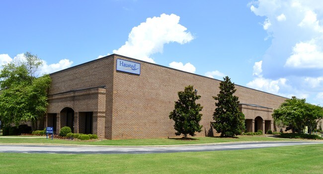
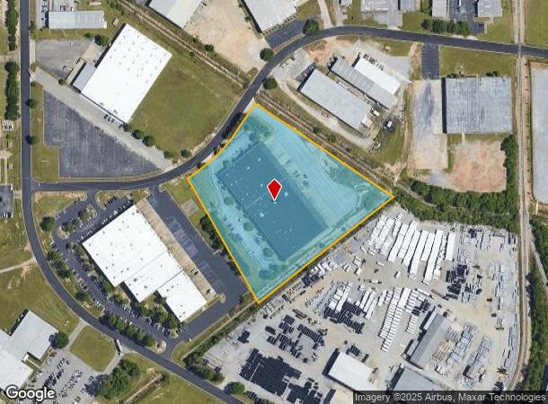
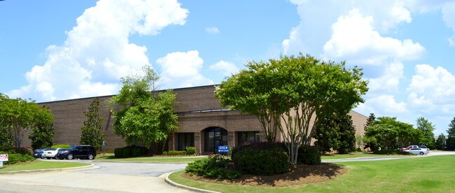
Property Record
2511 Midpark Rd, Montgomery, AL 36109
NEARBY LISTINGS FOR SALE OR LEASE
Property Detail
2511 Midpark Rd
Montgomery, AL
Gunter Industrial Park 1
10-01-02-2-002-002.000
1001022002002000
Publicstorage
Montgomery
X
Alabama
01051C0465F
2-9b
2025
6.20 AC
2025
North Montgomery
005302
Montgomery
81,072 SF
DEMOGRAPHICS near 2511 Midpark Rd
1 Mile
3 Mile
5 Mile
2024 Total Population
4,184
42,164
98,665
2029 Population
4,033
41,010
96,156
Pop Growth 2024-2029
(3.61%)
(2.74%)
(2.54%)
Average Age
40
38
38
2024 Total Households
1,639
17,542
41,135
HH Growth 2024-2029
(3.84%)
(2.78%)
(2.62%)
Median Household Inc
$60,735
$48,557
$50,170
Avg Household Size
2.40
2.30
2.20
2024 Avg HH Vehicles
2.00
2.00
2.00
Median Home Value
$142,452
$128,973
$143,334
Median Year Built
1978
1973
1976
Nearby Places
- Restaurants
- Banks
- Shops
- Fitness
- Groceries
PUBLIC TRANSPORTATION
AIRPORT
Montgomery Regional (Dannelly Field)
DRIVE
WALK
Distance
Montgomery Regional (Dannelly Field)
25 min
17.8 mi
Freight Ports
Port of Panama City
DRIVE
WALK
Distance
Port of Panama City
241 min
189.4 mi
SALE & LEASE HISTORY
LISTING DATE
SALE/LEASE

Sep 25, 2016
For Lease
Nearby Properties
Address
Land Use
TOTAL SIZE
Lot Size
Zoning
Address
Land Use
TOTAL SIZE
Lot Size
Zoning
427,546 SF
37.68 AC
M-1
Address
Land Use
TOTAL SIZE
Lot Size
Zoning
385,644 SF
26.60 AC
B-2
Address
Land Use
TOTAL SIZE
Lot Size
Zoning
31,205 SF
59 AC
INST
Address
Land Use
TOTAL SIZE
Lot Size
Zoning
7,040 SF
11.70 AC
R-65-M
Address
Land Use
TOTAL SIZE
Lot Size
Zoning
216,654 SF
26.49 AC
B-2
Address
Land Use
TOTAL SIZE
Lot Size
Zoning
5,606 SF
21 AC
R-75-M
Address
Land Use
TOTAL SIZE
Lot Size
Zoning
591,904 SF
26 AC
M-1
Address
Land Use
TOTAL SIZE
Lot Size
Zoning
122,119 SF
21 AC
R-75-S
Address
Land Use
TOTAL SIZE
Lot Size
Zoning
108,176 SF
4.27 AC
B-1-B
Address
Land Use
TOTAL SIZE
Lot Size
Zoning
154,375 SF
21.19 AC
B-3
Address
Land Use
TOTAL SIZE
Lot Size
Zoning
75,510 SF
10.97 AC
B-2
Address
Land Use
TOTAL SIZE
Lot Size
Zoning
84,764 SF
5.20 AC
B-2
Address
Land Use
TOTAL SIZE
Lot Size
Zoning
65,394 SF
13 AC
B-2
Address
Land Use
TOTAL SIZE
Lot Size
Zoning
96,168 SF
95.16 AC
INST
Address
Land Use
TOTAL SIZE
Lot Size
Zoning
3,458 SF
15.34 AC
R-65-M
Address
Land Use
TOTAL SIZE
Lot Size
Zoning
2,200 SF
11.06 AC
R-75-M
Address
Land Use
TOTAL SIZE
Lot Size
Zoning
6,024 SF
17.30 AC
R-75-M
Address
Land Use
TOTAL SIZE
Lot Size
Zoning
187,340 SF
22.80 AC
M-1
Address
Land Use
TOTAL SIZE
Lot Size
Zoning
11,190 SF
13.75 AC
AGR-1
Address
Land Use
TOTAL SIZE
Lot Size
Zoning
30,747 SF
21.58 AC
M-1
Address
Land Use
TOTAL SIZE
Lot Size
Zoning
88,034 SF
6.60 AC
M-1
Address
Land Use
TOTAL SIZE
Lot Size
Zoning
3,320 SF
11 AC
R-75-M
Address
Land Use
TOTAL SIZE
Lot Size
Zoning
67,643 SF
12.82 AC
M-1
Address
Land Use
TOTAL SIZE
Lot Size
Zoning
8,014 SF
7.10 AC
R-75-M
Address
Land Use
TOTAL SIZE
Lot Size
Zoning
244,062 SF
12.94 AC
M-1
Address
Land Use
TOTAL SIZE
Lot Size
Zoning
18,557 SF
9.41 AC
R-75-S
Address
Land Use
TOTAL SIZE
Lot Size
Zoning
138,670 SF
3.89 AC
B-2
Address
Land Use
TOTAL SIZE
Lot Size
Zoning
1,910 SF
11.09 AC
R-65-M
Address
Land Use
TOTAL SIZE
Lot Size
Zoning
47,345 SF
8.44 AC
B-2
Address
Land Use
TOTAL SIZE
Lot Size
Zoning
2,762 SF
7.90 AC
B-2
The World's #1 Commercial Real Estate Marketplace
Connect with us
© 2025 CoStar Group
The information above has been obtained from sources believed reliable. While we do not doubt its accuracy we have not verified it and make no guarantee, warranty or representation about it. It is your responsibility to independently confirm its accuracy and completeness. Any projections, opinions, assumptions, or estimates used are for example only and do not represent the current or future performance of the property. The value of this transaction to you depends on tax and other factors which should be evaluated by your tax, financial, and legal advisors. You and your advisors should conduct a careful, independent investigation of the property to determine to your satisfaction the suitability of the property for your needs.