Property Record
2530 Boston Rd, Bronx, NY 10467
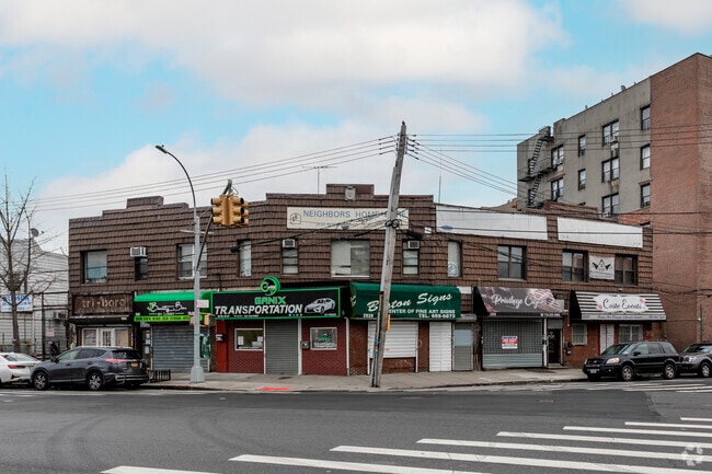

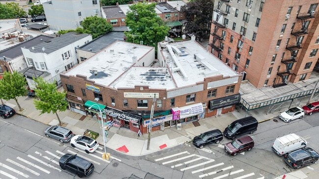

This Property Is For Sale
NEARBY LISTINGS FOR SALE OR LEASE
Property Detail
2530 Boston Rd
04439-0012
Lorillard Spencer Estate
Storebuilding
Bronx
X
New York
3604970101F
12
2024
0.16 AC
2025
Bronx
032800
Westchester/So Connecticut
7,900 SF
New York-Jersey City-White Plains, NY-NJ
DEMOGRAPHICS near 2530 Boston Rd
1 mile
3 mile
5 mile
2024 Total Population
97,123
942,703
1,763,636
2029 Population
88,517
868,436
1,639,110
Pop Growth 2024-2029
(8.86%)
(7.88%)
(7.06%)
Average Age
39
38
39
2024 Total Households
35,594
334,135
636,578
HH Growth 2024-2029
(9.49%)
(8.58%)
(7.62%)
Median Household Inc
$53,128
$46,631
$46,924
Avg Household Size
2.60
2.70
2.60
2024 Avg HH Vehicles
1.00
1.00
1.00
Median Home Value
$569,155
$497,012
$500,960
Median Year Built
1950
1950
1951
Nearby Places
Map Layers
Map Styles
 Street
 Aerial
Transit
 Traffic
 Biking
Places
Listings with unknown addresses are not visible on the map
- Restaurants
- Banks
- Shops
- Fitness
- Groceries
PUBLIC TRANSPORTATION
TRANSIT/SUBWAY
Allerton Avenue (2 - New York MTA Subway (The Subway), 5 - New York MTA Subway (The Subway))
Drive
Walk
Distance
Allerton Avenue (2 - New York MTA Subway (The Subway), 5 - New York MTA Subway (The Subway))
2 min
6 min
0.3 mi
Pelham Parkway (2,5 Line) (2 - New York MTA Subway (The Subway), 5 - New York MTA Subway (The Subway))
Drive
Walk
Distance
Pelham Parkway (2,5 Line) (2 - New York MTA Subway (The Subway), 5 - New York MTA Subway (The Subway))
3 min
11 min
0.5 mi
Burke Avenue (2 - New York MTA Subway (The Subway), 5 - New York MTA Subway (The Subway))
Drive
Walk
Distance
Burke Avenue (2 - New York MTA Subway (The Subway), 5 - New York MTA Subway (The Subway))
4 min
13 min
0.6 mi
Pelham Parkway (5 Line) (5 - New York MTA Subway (The Subway))
Drive
Walk
Distance
Pelham Parkway (5 Line) (5 - New York MTA Subway (The Subway))
5 min
16 min
0.8 mi
COMMUTER RAIL
Botanical Garden Station (Harlem Line - Metro-North Commuter Railroad Company (Metro-North))
Drive
Walk
Distance
Botanical Garden Station (Harlem Line - Metro-North Commuter Railroad Company (Metro-North))
7 min
1.5 mi
Fordham Station (Harlem Line - Metro-North Commuter Railroad Company (Metro-North), New Haven Line - Metro-North Commuter Railroad Company (Metro-North))
Drive
Walk
Distance
Fordham Station (Harlem Line - Metro-North Commuter Railroad Company (Metro-North), New Haven Line - Metro-North Commuter Railroad Company (Metro-North))
9 min
2.2 mi
AIRPORT
LaGuardia
Drive
Walk
Distance
LaGuardia
20 min
11.4 mi
John F Kennedy International
Drive
Walk
Distance
John F Kennedy International
31 min
19.7 mi
Westchester County
Drive
Walk
Distance
Westchester County
32 min
22.6 mi
Nearby Properties
Address
Land Use
TOTAL SIZE
Lot Size
Zoning
Address
Land Use
TOTAL SIZE
Lot Size
Zoning
115.90 AC
R6
Address
Land Use
TOTAL SIZE
Lot Size
Zoning
115.90 AC
R6
Address
Land Use
TOTAL SIZE
Lot Size
Zoning
115.90 AC
R6
Address
Land Use
TOTAL SIZE
Lot Size
Zoning
115.90 AC
R6
Address
Land Use
TOTAL SIZE
Lot Size
Zoning
115.90 AC
R6
Address
Land Use
TOTAL SIZE
Lot Size
Zoning
115.90 AC
R6
Address
Land Use
TOTAL SIZE
Lot Size
Zoning
115.90 AC
R6
Address
Land Use
TOTAL SIZE
Lot Size
Zoning
115.90 AC
R6
Address
Land Use
TOTAL SIZE
Lot Size
Zoning
115.90 AC
R6
Address
Land Use
TOTAL SIZE
Lot Size
Zoning
115.90 AC
R6
Address
Land Use
TOTAL SIZE
Lot Size
Zoning
115.90 AC
R6
Address
Land Use
TOTAL SIZE
Lot Size
Zoning
115.90 AC
R6
Address
Land Use
TOTAL SIZE
Lot Size
Zoning
115.90 AC
R6
Address
Land Use
TOTAL SIZE
Lot Size
Zoning
115.90 AC
R6
Address
Land Use
TOTAL SIZE
Lot Size
Zoning
115.90 AC
R6
Address
Land Use
TOTAL SIZE
Lot Size
Zoning
115.90 AC
R6
Address
Land Use
TOTAL SIZE
Lot Size
Zoning
115.90 AC
R6
Address
Land Use
TOTAL SIZE
Lot Size
Zoning
115.90 AC
R6
Address
Land Use
TOTAL SIZE
Lot Size
Zoning
115.90 AC
R6
Address
Land Use
TOTAL SIZE
Lot Size
Zoning
115.90 AC
R6
Address
Land Use
TOTAL SIZE
Lot Size
Zoning
115.90 AC
R6
Address
Land Use
TOTAL SIZE
Lot Size
Zoning
115.90 AC
R6
Address
Land Use
TOTAL SIZE
Lot Size
Zoning
115.90 AC
R6
Address
Land Use
TOTAL SIZE
Lot Size
Zoning
115.90 AC
R6
Address
Land Use
TOTAL SIZE
Lot Size
Zoning
115.90 AC
R6
Address
Land Use
TOTAL SIZE
Lot Size
Zoning
1,299,700 SF
29.82 AC
R6
Address
Land Use
TOTAL SIZE
Lot Size
Zoning
550,000 SF
8.75 AC
M1-1
Address
Land Use
TOTAL SIZE
Lot Size
Zoning
13,243,398 SF
115.90 AC
R6
Address
Land Use
TOTAL SIZE
Lot Size
Zoning
1,743,584 SF
77.87 AC
R6
Address
Land Use
TOTAL SIZE
Lot Size
Zoning
44.83 AC
R6
The World's #1 Commercial Real Estate Marketplace
Connect with us
© 2026 CoStar Group
The information above has been obtained from sources believed reliable. While we do not doubt its accuracy we have not verified it and make no guarantee, warranty or representation about it. It is your responsibility to independently confirm its accuracy and completeness. Any projections, opinions, assumptions, or estimates used are for example only and do not represent the current or future performance of the property. The value of this transaction to you depends on tax and other factors which should be evaluated by your tax, financial, and legal advisors. You and your advisors should conduct a careful, independent investigation of the property to determine to your satisfaction the suitability of the property for your needs.