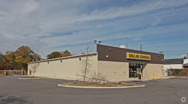
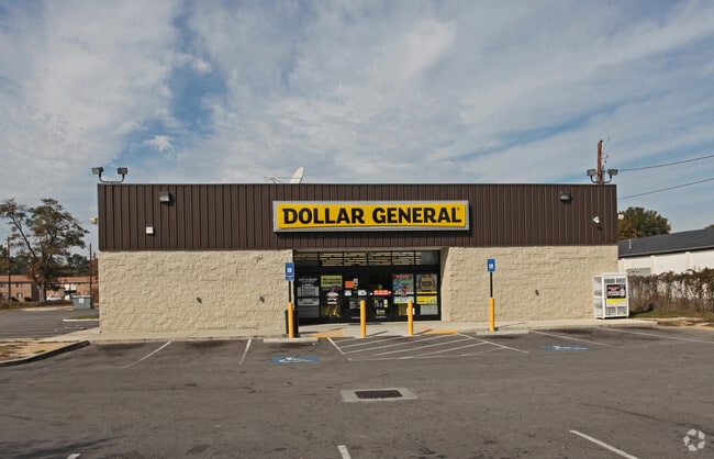
Property Record
2549 Deans Bridge Rd, Augusta, GA 30906

Save to a Folder
{{folder.Name}}
{{folder.ListingIds.length}} Properties
{{folder.ListingIds.length}} Property
Create a New Folder
Property Detail
2549 Deans Bridge Rd
0713201000
2549 DEANS BRIDGE RD
Commercialacreage
Richmond
B-2
Georgia
B and X Area of moderate flood hazard, usually the area between the limits of the 100-year and 500-year floods.
0
2025
1.49 AC
2025
South Richmond County
010300
Augusta/Richmond County
9,146 SF
Augusta-Richmond County, GA-SC
NEARBY LISTINGS FOR SALE OR LEASE
DEMOGRAPHICS near 2549 Deans Bridge Rd
1 mile
3 mile
5 mile
2025 Total Population
6,439
54,472
124,377
2030 Population
6,484
54,857
124,688
Pop Growth 2025-2030
+ 0.70%
+ 0.71%
+ 0.25%
Average Age
39
39
39
2025 Total Households
2,680
22,881
52,784
HH Growth 2025-2030
+ 0.78%
+ 0.91%
+ 0.49%
Median Household Inc
$23,671
$40,276
$47,787
Avg Household Size
2.30
2.20
2.20
2025 Avg HH Vehicles
1.00
1.00
2.00
Median Home Value
$111,562
$163,854
$186,892
Median Year Built
1958
1960
1970
Nearby Places
Map Layers
Map Styles
 Street
 Aerial
Layers
 Traffic
 Biking
Places
Listings with unknown addresses are not visible on the map
- Restaurants
- Banks
- Shops
- Fitness
- Groceries
PUBLIC TRANSPORTATION
AIRPORT
Augusta Regional at Bush Field
Drive
Walk
Distance
Augusta Regional at Bush Field
17 min
7.0 mi
SALE & LEASE HISTORY
LISTING DATE
SALE/LEASE

Jul 25, 2018
For Sale
Apr 25, 2025
For Sale
Nearby Properties
Address
Land Use
TOTAL SIZE
Lot Size
Zoning
Address
Land Use
TOTAL SIZE
Lot Size
Zoning
954,084 SF
18.30 AC
B-2
Address
Land Use
TOTAL SIZE
Lot Size
Zoning
627,990 SF
20 AC
P-1
Address
Land Use
TOTAL SIZE
Lot Size
Zoning
1,100 SF
97.38 AC
R-1A
Address
Land Use
TOTAL SIZE
Lot Size
Zoning
202,994 SF
19.25 AC
P-1
Address
Land Use
TOTAL SIZE
Lot Size
Zoning
179,743 SF
9.52 AC
007
Address
Land Use
TOTAL SIZE
Lot Size
Zoning
102,429 SF
7.31 AC
PUD
Address
Land Use
TOTAL SIZE
Lot Size
Zoning
255,834 SF
5.56 AC
B-1
Address
Land Use
TOTAL SIZE
Lot Size
Zoning
102,748 SF
22.60 AC
R-3B
Address
Land Use
TOTAL SIZE
Lot Size
Zoning
1,428 SF
75.91 AC
R-1A
Address
Land Use
TOTAL SIZE
Lot Size
Zoning
38,080 SF
19.19 AC
R-3B
Address
Land Use
TOTAL SIZE
Lot Size
Zoning
1,782 SF
26.27 AC
R-3A
Address
Land Use
TOTAL SIZE
Lot Size
Zoning
6,323 SF
25.49 AC
R-3C
Address
Land Use
TOTAL SIZE
Lot Size
Zoning
241,284 SF
20.61 AC
R-1A
Address
Land Use
TOTAL SIZE
Lot Size
Zoning
21,615 SF
207.78 AC
R-1
Address
Land Use
TOTAL SIZE
Lot Size
Zoning
56,631 SF
11.62 AC
R-1A, B-2
Address
Land Use
TOTAL SIZE
Lot Size
Zoning
90,447 SF
1.28 AC
B-1
Address
Land Use
TOTAL SIZE
Lot Size
Zoning
431,971 SF
21.07 AC
007
Address
Land Use
TOTAL SIZE
Lot Size
Zoning
4,507 SF
56.06 AC
HI
Address
Land Use
TOTAL SIZE
Lot Size
Zoning
4,947 SF
71.24 AC
R-3B
Address
Land Use
TOTAL SIZE
Lot Size
Zoning
73,064 SF
3.11 AC
B-1 SPEX
Address
Land Use
TOTAL SIZE
Lot Size
Zoning
52,896 SF
22.90 AC
B-1
Address
Land Use
TOTAL SIZE
Lot Size
Zoning
27,976 SF
1.25 AC
B-1_R-1C S
Address
Land Use
TOTAL SIZE
Lot Size
Zoning
119,427 SF
1.57 AC
P-1
Address
Land Use
TOTAL SIZE
Lot Size
Zoning
44,160 SF
12.46 AC
R-3B
Address
Land Use
TOTAL SIZE
Lot Size
Zoning
35,263 SF
19.63 AC
B-1
Address
Land Use
TOTAL SIZE
Lot Size
Zoning
30,583 SF
15.28 AC
B-1
Address
Land Use
TOTAL SIZE
Lot Size
Zoning
38,412 SF
22.51 AC
R-1A
Address
Land Use
TOTAL SIZE
Lot Size
Zoning
193,478 SF
24.91 AC
B-2
Address
Land Use
TOTAL SIZE
Lot Size
Zoning
24,304 SF
11 AC
R-1A
Address
Land Use
TOTAL SIZE
Lot Size
Zoning
209,630 SF
4.83 AC
B-1
The World's #1 Commercial Real Estate Marketplace
Connect with us
© 2026 CoStar Group
The information above has been obtained from sources believed reliable. While we do not doubt its accuracy we have not verified it and make no guarantee, warranty or representation about it. It is your responsibility to independently confirm its accuracy and completeness. Any projections, opinions, assumptions, or estimates used are for example only and do not represent the current or future performance of the property. The value of this transaction to you depends on tax and other factors which should be evaluated by your tax, financial, and legal advisors. You and your advisors should conduct a careful, independent investigation of the property to determine to your satisfaction the suitability of the property for your needs.