Property Record
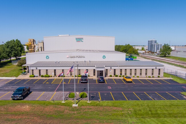
2555 N Partnership Blvd, Springfield, MO 65803


Property Detail
2555 N Partnership Blvd
12-03-400-029
PARTNERSHIP INDUSTRIAL CENTER PHASE 8 LOT 1
Manufacturinglight
Greene
INC
Missouri
B and X Area of moderate flood hazard, usually the area between the limits of the 100-year and 500-year floods.
1
2025
4.88 AC
2025
Northeast
003702
Springfield
34,238 SF
Springfield, MO
NEARBY LISTINGS FOR SALE OR LEASE
DEMOGRAPHICS near 2555 N Partnership Blvd
1 mile
3 mile
5 mile
2025 Total Population
218
12,767
68,094
2030 Population
230
13,174
69,999
Pop Growth 2025-2030
+ 5.50%
+ 3.19%
+ 2.80%
Average Age
41
41
39
2025 Total Households
84
5,704
29,247
HH Growth 2025-2030
+ 4.76%
+ 3.35%
+ 2.98%
Median Household Inc
$114,999
$64,461
$54,829
Avg Household Size
2.60
2.20
2.10
2025 Avg HH Vehicles
2.00
2.00
2.00
Median Home Value
$366,666
$284,805
$234,085
Median Year Built
2010
1990
1975
Nearby Places
Map Layers
Map Styles
 Street
 Aerial
Layers
 Traffic
 Biking
Places
Listings with unknown addresses are not visible on the map
- Restaurants
- Banks
- Shops
- Fitness
- Groceries
PUBLIC TRANSPORTATION
AIRPORT
Springfield-Branson Ntl
Drive
Walk
Distance
Springfield-Branson Ntl
26 min
15.2 mi
SALE & LEASE HISTORY
LISTING DATE
SALE/LEASE

Jun 20, 2022
For Sale
Nearby Properties
Address
Land Use
TOTAL SIZE
Lot Size
Zoning
Address
Land Use
TOTAL SIZE
Lot Size
Zoning
68.92 AC
INC
Address
Land Use
TOTAL SIZE
Lot Size
Zoning
35.56 AC
INC
Address
Land Use
TOTAL SIZE
Lot Size
Zoning
617,990 SF
49.88 AC
INC
Address
Land Use
TOTAL SIZE
Lot Size
Zoning
20.01 AC
Address
Land Use
TOTAL SIZE
Lot Size
Zoning
22.01 AC
INC.
Address
Land Use
TOTAL SIZE
Lot Size
Zoning
1,728,457 SF
123.60 AC
INC
Address
Land Use
TOTAL SIZE
Lot Size
Zoning
340,000 SF
37.93 AC
INC
Address
Land Use
TOTAL SIZE
Lot Size
Zoning
359,020 SF
14 AC
INC
Address
Land Use
TOTAL SIZE
Lot Size
Zoning
18.35 AC
Address
Land Use
TOTAL SIZE
Lot Size
Zoning
37.01 AC
INC
Address
Land Use
TOTAL SIZE
Lot Size
Zoning
349,216 SF
29.46 AC
INC
Address
Land Use
TOTAL SIZE
Lot Size
Zoning
805,370 SF
54.30 AC
INC
Address
Land Use
TOTAL SIZE
Lot Size
Zoning
24.54 AC
INC.
Address
Land Use
TOTAL SIZE
Lot Size
Zoning
1,825 SF
4.31 AC
INC
Address
Land Use
TOTAL SIZE
Lot Size
Zoning
143,774 SF
5.85 AC
INC
Address
Land Use
TOTAL SIZE
Lot Size
Zoning
290,844 SF
20.78 AC
INC
Address
Land Use
TOTAL SIZE
Lot Size
Zoning
127,740 SF
27.70 AC
INC
Address
Land Use
TOTAL SIZE
Lot Size
Zoning
92,702 SF
42.54 AC
INC
Address
Land Use
TOTAL SIZE
Lot Size
Zoning
20.11 AC
INC
Address
Land Use
TOTAL SIZE
Lot Size
Zoning
110,347 SF
14.58 AC
INC
Address
Land Use
TOTAL SIZE
Lot Size
Zoning
256,172 SF
19.03 AC
INC
Address
Land Use
TOTAL SIZE
Lot Size
Zoning
2.75 AC
INC
Address
Land Use
TOTAL SIZE
Lot Size
Zoning
79.50 AC
INC
Address
Land Use
TOTAL SIZE
Lot Size
Zoning
4.62 AC
INC
Address
Land Use
TOTAL SIZE
Lot Size
Zoning
31.56 AC
INC
Address
Land Use
TOTAL SIZE
Lot Size
Zoning
328,252 SF
18.67 AC
INC
Address
Land Use
TOTAL SIZE
Lot Size
Zoning
32.40 AC
INC
Address
Land Use
TOTAL SIZE
Lot Size
Zoning
162,312 SF
7.84 AC
INC
Address
Land Use
TOTAL SIZE
Lot Size
Zoning
16.03 AC
INC
Address
Land Use
TOTAL SIZE
Lot Size
Zoning
11.68 AC
INC
The World's #1 Commercial Real Estate Marketplace
Connect with us
© 2026 CoStar Group
The information above has been obtained from sources believed reliable. While we do not doubt its accuracy we have not verified it and make no guarantee, warranty or representation about it. It is your responsibility to independently confirm its accuracy and completeness. Any projections, opinions, assumptions, or estimates used are for example only and do not represent the current or future performance of the property. The value of this transaction to you depends on tax and other factors which should be evaluated by your tax, financial, and legal advisors. You and your advisors should conduct a careful, independent investigation of the property to determine to your satisfaction the suitability of the property for your needs.