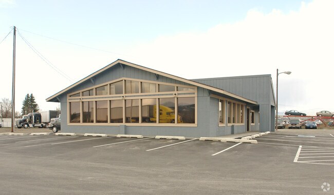
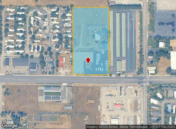
Property Record
2561 W Seltice Way, Post Falls, ID 83854

NEARBY LISTINGS FOR SALE OR LEASE
Property Detail
2561 W Seltice Way
P375032127AA
Greenacres
Commercialnec
GREENACRES IRR DISTRICT PLAT 5, TR 127 EX RW 3251N05W
X
Kootenai
16055C0380E
Idaho
2025
4.72 AC
2025
Post Falls
000401
Other Market Areas
2,992 SF
Coeur d'Alene, ID
DEMOGRAPHICS near 2561 W Seltice Way
1 Mile
3 Mile
5 Mile
2024 Total Population
5,624
33,166
62,549
2029 Population
6,726
39,522
73,936
Pop Growth 2024-2029
+ 19.59%
+ 19.16%
+ 18.20%
Average Age
38
38
39
2024 Total Households
2,089
12,381
23,472
HH Growth 2024-2029
+ 19.24%
+ 18.83%
+ 17.95%
Median Household Inc
$61,703
$67,250
$70,069
Avg Household Size
2.60
2.60
2.60
2024 Avg HH Vehicles
2.00
2.00
2.00
Median Home Value
$420,898
$381,373
$414,524
Median Year Built
2004
2001
2000
Nearby Places
Map Layers
Map Styles
 Street
 Aerial
- Restaurants
- Banks
- Shops
- Fitness
- Groceries
PUBLIC TRANSPORTATION
AIRPORT
Spokane International
DRIVE
WALK
Distance
Spokane International
37 min
28.3 mi
Freight Ports
Port of Everett
DRIVE
WALK
Distance
Port of Everett
364 min
323.9 mi
SALE & LEASE HISTORY
LISTING DATE
SALE/LEASE

Oct 20, 2020
For Lease
Nearby Properties
Address
Land Use
TOTAL SIZE
Lot Size
Zoning
Address
Land Use
TOTAL SIZE
Lot Size
Zoning
135,646 SF
18.40 AC
Address
Land Use
TOTAL SIZE
Lot Size
Zoning
89,184 SF
8.69 AC
Address
Land Use
TOTAL SIZE
Lot Size
Zoning
53,118 SF
7.61 AC
Address
Land Use
TOTAL SIZE
Lot Size
Zoning
150,900 SF
7.24 AC
AG
Address
Land Use
TOTAL SIZE
Lot Size
Zoning
104,852 SF
5.70 AC
Address
Land Use
TOTAL SIZE
Lot Size
Zoning
42,636 SF
24.81 AC
Address
Land Use
TOTAL SIZE
Lot Size
Zoning
235,906 SF
13.17 AC
Address
Land Use
TOTAL SIZE
Lot Size
Zoning
94,960 SF
7.45 AC
Address
Land Use
TOTAL SIZE
Lot Size
Zoning
25,698 SF
11.33 AC
Address
Land Use
TOTAL SIZE
Lot Size
Zoning
57,936 SF
7.88 AC
Address
Land Use
TOTAL SIZE
Lot Size
Zoning
465,080 SF
31.43 AC
Address
Land Use
TOTAL SIZE
Lot Size
Zoning
145,377 SF
35.35 AC
Address
Land Use
TOTAL SIZE
Lot Size
Zoning
26,619 SF
15 AC
Address
Land Use
TOTAL SIZE
Lot Size
Zoning
165,984 SF
9.61 AC
Address
Land Use
TOTAL SIZE
Lot Size
Zoning
129,238 SF
24.58 AC
AG
Address
Land Use
TOTAL SIZE
Lot Size
Zoning
82,700 SF
21 AC
Address
Land Use
TOTAL SIZE
Lot Size
Zoning
156,211 SF
17.09 AC
Address
Land Use
TOTAL SIZE
Lot Size
Zoning
106,656 SF
4.60 AC
Address
Land Use
TOTAL SIZE
Lot Size
Zoning
199,920 SF
18.36 AC
COMDEV
Address
Land Use
TOTAL SIZE
Lot Size
Zoning
108,524 SF
20.34 AC
Address
Land Use
TOTAL SIZE
Lot Size
Zoning
85,000 SF
1.22 AC
Address
Land Use
TOTAL SIZE
Lot Size
Zoning
64,648 SF
14.82 AC
AG
Address
Land Use
TOTAL SIZE
Lot Size
Zoning
16,185 SF
60.19 AC
Address
Land Use
TOTAL SIZE
Lot Size
Zoning
60,246 SF
3.67 AC
Address
Land Use
TOTAL SIZE
Lot Size
Zoning
59,039 SF
4.17 AC
Address
Land Use
TOTAL SIZE
Lot Size
Zoning
103,056 SF
8.18 AC
Address
Land Use
TOTAL SIZE
Lot Size
Zoning
56,150 SF
1.56 AC
Address
Land Use
TOTAL SIZE
Lot Size
Zoning
115,992 SF
6.87 AC
Address
Land Use
TOTAL SIZE
Lot Size
Zoning
21,008 SF
2.53 AC
The World's #1 Commercial Real Estate Marketplace
Connect with us
© 2025 CoStar Group
The information above has been obtained from sources believed reliable. While we do not doubt its accuracy we have not verified it and make no guarantee, warranty or representation about it. It is your responsibility to independently confirm its accuracy and completeness. Any projections, opinions, assumptions, or estimates used are for example only and do not represent the current or future performance of the property. The value of this transaction to you depends on tax and other factors which should be evaluated by your tax, financial, and legal advisors. You and your advisors should conduct a careful, independent investigation of the property to determine to your satisfaction the suitability of the property for your needs.