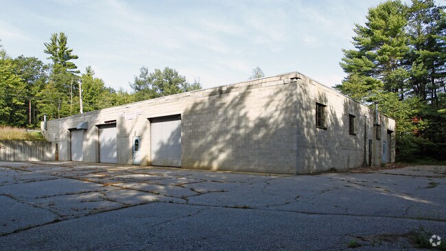
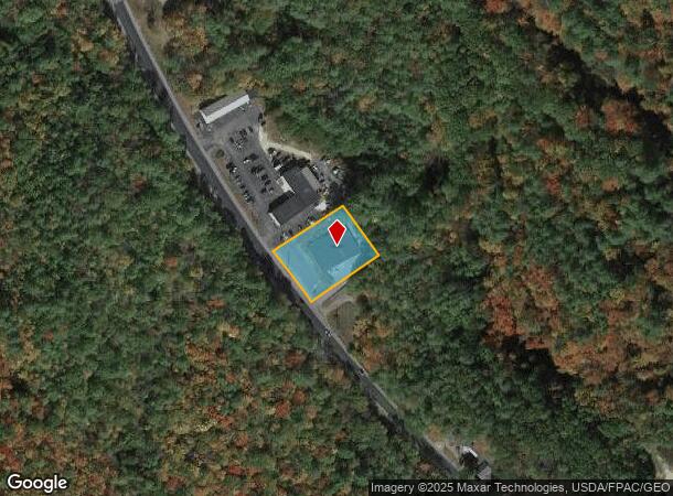
Property Record
257 Nh Route 11, Farmington, NH 03835

NEARBY LISTINGS FOR SALE OR LEASE
-
-
View all Farmington listings for lease on LoopNet.com
Property Detail
257 Nh Route 11
FRMN-000014R-000000-000005
Strafford
Commercialbuilding
New Hampshire
X
5 s:0-0
33017C0181D
0.75 AC
2024
Strafford County
2024
Boston
087001
Boston-Cambridge-Newton, MA-NH
8,745 SF
DEMOGRAPHICS near 257 Nh Route 11
1 Mile
3 Mile
5 Mile
2024 Total Population
142
7,938
25,733
2029 Population
149
8,294
26,859
Pop Growth 2024-2029
+ 4.93%
+ 4.48%
+ 4.38%
Average Age
43
43
42
2024 Total Households
57
3,304
10,760
HH Growth 2024-2029
+ 3.51%
+ 4.51%
+ 4.41%
Median Household Inc
$105,769
$87,752
$84,990
Avg Household Size
2.50
2.40
2.40
2024 Avg HH Vehicles
2.00
2.00
2.00
Median Home Value
$366,666
$250,912
$250,997
Median Year Built
1989
1981
1976
Nearby Places
Map Layers
Map Styles
 Street
 Aerial
- Restaurants
- Banks
- Shops
- Fitness
- Groceries
PUBLIC TRANSPORTATION
AIRPORT
Portsmouth International at Pease
DRIVE
WALK
Distance
Portsmouth International at Pease
35 min
24.1 mi
Freight Ports
Portland, ME
DRIVE
WALK
Distance
Portland, ME
76 min
54.1 mi
SALE & LEASE HISTORY
LISTING DATE
SALE/LEASE

Sep 25, 2016
For Lease
Sep 23, 2016
For Sale
Nearby Properties
Address
Land Use
TOTAL SIZE
Lot Size
Zoning
Address
Land Use
TOTAL SIZE
Lot Size
Zoning
274,144 SF
73.08 AC
GRD
Address
Land Use
TOTAL SIZE
Lot Size
Zoning
224,153 SF
34.36 AC
GRD
Address
Land Use
TOTAL SIZE
Lot Size
Zoning
82,235 SF
20 AC
UR URB
Address
Land Use
TOTAL SIZE
Lot Size
Zoning
1,156 SF
1.95 AC
VC VIL
Address
Land Use
TOTAL SIZE
Lot Size
Zoning
59,235 SF
22.08 AC
A
Address
Land Use
TOTAL SIZE
Lot Size
Zoning
84,700 SF
5.76 AC
GRD
Address
Land Use
TOTAL SIZE
Lot Size
Zoning
16,444 SF
6.41 AC
GRD
Address
Land Use
TOTAL SIZE
Lot Size
Zoning
4,000 SF
68 AC
GRD
Address
Land Use
TOTAL SIZE
Lot Size
Zoning
87.64 AC
A
Address
Land Use
TOTAL SIZE
Lot Size
Zoning
32,506 SF
12.36 AC
GRD
Address
Land Use
TOTAL SIZE
Lot Size
Zoning
21,784 SF
6.09 AC
GRD
Address
Land Use
TOTAL SIZE
Lot Size
Zoning
41,846 SF
3.60 AC
GRD
Address
Land Use
TOTAL SIZE
Lot Size
Zoning
66,994 SF
38.56 AC
IB IND
Address
Land Use
TOTAL SIZE
Lot Size
Zoning
1,288 SF
72 AC
A
Address
Land Use
TOTAL SIZE
Lot Size
Zoning
5,048 SF
165.49 AC
A
Address
Land Use
TOTAL SIZE
Lot Size
Zoning
15,085 SF
83.25 AC
SR SUB
Address
Land Use
TOTAL SIZE
Lot Size
Zoning
17,240 SF
4.01 AC
GRD
Address
Land Use
TOTAL SIZE
Lot Size
Zoning
10,172 SF
92.55 AC
A
Address
Land Use
TOTAL SIZE
Lot Size
Zoning
32.73 AC
SR SUB
Address
Land Use
TOTAL SIZE
Lot Size
Zoning
39 AC
A
Address
Land Use
TOTAL SIZE
Lot Size
Zoning
1,800 SF
5.50 AC
CIBO C
Address
Land Use
TOTAL SIZE
Lot Size
Zoning
24,000 SF
6.67 AC
GRD
Address
Land Use
TOTAL SIZE
Lot Size
Zoning
3,472 SF
4.65 AC
CB COM
Address
Land Use
TOTAL SIZE
Lot Size
Zoning
48 AC
SR SUB
Address
Land Use
TOTAL SIZE
Lot Size
Zoning
6,006 SF
3.50 AC
GRD
Address
Land Use
TOTAL SIZE
Lot Size
Zoning
3,332 SF
3 AC
AR AGR
Address
Land Use
TOTAL SIZE
Lot Size
Zoning
1,679 SF
39.34 AC
A
Address
Land Use
TOTAL SIZE
Lot Size
Zoning
18,875 SF
5.44 AC
GRD
Address
Land Use
TOTAL SIZE
Lot Size
Zoning
2,583 SF
1.30 AC
LOW DE
Address
Land Use
TOTAL SIZE
Lot Size
Zoning
10,332 SF
2.88 AC
GRD
The World's #1 Commercial Real Estate Marketplace
Connect with us
© 2026 CoStar Group
The information above has been obtained from sources believed reliable. While we do not doubt its accuracy we have not verified it and make no guarantee, warranty or representation about it. It is your responsibility to independently confirm its accuracy and completeness. Any projections, opinions, assumptions, or estimates used are for example only and do not represent the current or future performance of the property. The value of this transaction to you depends on tax and other factors which should be evaluated by your tax, financial, and legal advisors. You and your advisors should conduct a careful, independent investigation of the property to determine to your satisfaction the suitability of the property for your needs.