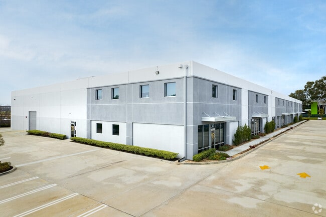
Property Record
26 Thomas, Irvine, CA 92618

Property Detail
26 Thomas
939-122-73
P BK 401 PG 31 PAR 1 UN 4 PAR 1 OF PM 401-31 OF CONDO PROJECT 939-12
Industrialgeneral
ORANGE
B and X Area of moderate flood hazard, usually the area between the limits of the 100-year and 500-year floods.
California
2024
Irvine Spectrum
2025
Orange County (California)
052410
Anaheim-Santa Ana-Irvine, CA
NEARBY LISTINGS FOR SALE OR LEASE
DEMOGRAPHICS near 26 Thomas
1 mile
3 mile
5 mile
2025 Total Population
3,078
112,312
344,607
2030 Population
3,041
113,603
344,811
Pop Growth 2025-2030
(1.20%)
+ 1.15%
+ 0.06%
Average Age
50
45
42
2025 Total Households
1,217
46,498
130,350
HH Growth 2025-2030
(1.40%)
+ 1.33%
+ 0.04%
Median Household Inc
$97,667
$103,801
$121,106
Avg Household Size
2.40
2.30
2.60
2025 Avg HH Vehicles
2.00
2.00
2.00
Median Home Value
$503,521
$755,282
$938,218
Median Year Built
1975
1981
1987
Nearby Places
Map Layers
Map Styles
 Street
 Aerial
Transit
 Traffic
 Biking
Places
Listings with unknown addresses are not visible on the map
- Restaurants
- Banks
- Shops
- Fitness
- Groceries
PUBLIC TRANSPORTATION
COMMUTER RAIL
Irvine (Inland Empire-Orange County Line - Southern California Regional Rail Authority (Metrolink), Orange County Line - Southern California Regional Rail Authority (Metrolink))
Drive
Walk
Distance
Irvine (Inland Empire-Orange County Line - Southern California Regional Rail Authority (Metrolink), Orange County Line - Southern California Regional Rail Authority (Metrolink))
3 min
1.4 mi
Tustin (Inland Empire-Orange County Line - Southern California Regional Rail Authority (Metrolink), Orange County Line - Southern California Regional Rail Authority (Metrolink))
Drive
Walk
Distance
Tustin (Inland Empire-Orange County Line - Southern California Regional Rail Authority (Metrolink), Orange County Line - Southern California Regional Rail Authority (Metrolink))
12 min
7.3 mi
AIRPORT
John Wayne/Orange County
Drive
Walk
Distance
John Wayne/Orange County
14 min
11.0 mi
Long Beach (Daugherty Field)
Drive
Walk
Distance
Long Beach (Daugherty Field)
38 min
31.0 mi
Ontario International
Drive
Walk
Distance
Ontario International
54 min
39.6 mi
SALE & LEASE HISTORY
LISTING DATE
SALE/LEASE

Sep 30, 2022
For Lease
Sep 16, 2019
For Lease
Jun 30, 2025
For Lease
Jun 15, 2021
For Lease
Jul 16, 2020
For Sale
Jul 10, 2024
For Lease
Feb 16, 2021
For Sale
Apr 21, 2025
For Lease
Apr 21, 2025
For Sale
Apr 10, 2025
For Sale
Nearby Properties
Address
Land Use
TOTAL SIZE
Lot Size
Zoning
Address
Land Use
TOTAL SIZE
Lot Size
Zoning
Address
Land Use
TOTAL SIZE
Lot Size
Zoning
74.73 AC
Address
Land Use
TOTAL SIZE
Lot Size
Zoning
Address
Land Use
TOTAL SIZE
Lot Size
Zoning
12.93 AC
Address
Land Use
TOTAL SIZE
Lot Size
Zoning
16.36 AC
Address
Land Use
TOTAL SIZE
Lot Size
Zoning
5.31 AC
Address
Land Use
TOTAL SIZE
Lot Size
Zoning
51.02 AC
Address
Land Use
TOTAL SIZE
Lot Size
Zoning
11.06 AC
Address
Land Use
TOTAL SIZE
Lot Size
Zoning
4.40 AC
Address
Land Use
TOTAL SIZE
Lot Size
Zoning
11.55 AC
Address
Land Use
TOTAL SIZE
Lot Size
Zoning
19.28 AC
Address
Land Use
TOTAL SIZE
Lot Size
Zoning
Address
Land Use
TOTAL SIZE
Lot Size
Zoning
Address
Land Use
TOTAL SIZE
Lot Size
Zoning
7.43 AC
Address
Land Use
TOTAL SIZE
Lot Size
Zoning
6.13 AC
Address
Land Use
TOTAL SIZE
Lot Size
Zoning
Address
Land Use
TOTAL SIZE
Lot Size
Zoning
Address
Land Use
TOTAL SIZE
Lot Size
Zoning
3.52 AC
Address
Land Use
TOTAL SIZE
Lot Size
Zoning
6.45 AC
Address
Land Use
TOTAL SIZE
Lot Size
Zoning
6.21 AC
Address
Land Use
TOTAL SIZE
Lot Size
Zoning
4.89 AC
Address
Land Use
TOTAL SIZE
Lot Size
Zoning
39.49 AC
Address
Land Use
TOTAL SIZE
Lot Size
Zoning
Address
Land Use
TOTAL SIZE
Lot Size
Zoning
21.92 AC
Address
Land Use
TOTAL SIZE
Lot Size
Zoning
Address
Land Use
TOTAL SIZE
Lot Size
Zoning
Address
Land Use
TOTAL SIZE
Lot Size
Zoning
28,700 SF
3.35 AC
Address
Land Use
TOTAL SIZE
Lot Size
Zoning
5.63 AC
Address
Land Use
TOTAL SIZE
Lot Size
Zoning
Address
Land Use
TOTAL SIZE
Lot Size
Zoning
4.98 AC
The World's #1 Commercial Real Estate Marketplace
Connect with us
© 2026 CoStar Group
The information above has been obtained from sources believed reliable. While we do not doubt its accuracy we have not verified it and make no guarantee, warranty or representation about it. It is your responsibility to independently confirm its accuracy and completeness. Any projections, opinions, assumptions, or estimates used are for example only and do not represent the current or future performance of the property. The value of this transaction to you depends on tax and other factors which should be evaluated by your tax, financial, and legal advisors. You and your advisors should conduct a careful, independent investigation of the property to determine to your satisfaction the suitability of the property for your needs.