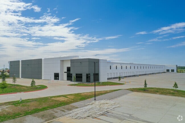
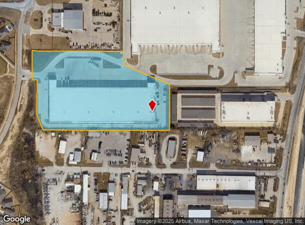
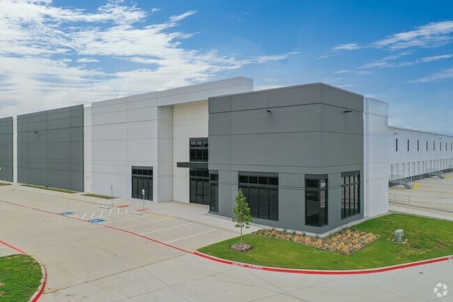
Property Record
2600 Graham Cracker Dr, Fort Worth, TX 76177
NEARBY LISTINGS FOR SALE OR LEASE
Property Detail
2600 Graham Cracker Dr
Dallas/Ft Worth
Miller Family Addition
Dallas-Fort Worth-Arlington, TX
R & S MILLER FAMILY ADDITION BLOCK 1 LOT 7 PLAT D220067160 (9.3355 @)
42642742
Tarrant
Commercialnec
Texas
2024
7
2025
9.33 AC
113931
NE Tarrant/Alliance
159,650 SF
DEMOGRAPHICS near 2600 Graham Cracker Dr
1 Mile
3 Mile
5 Mile
2024 Total Population
5,702
83,908
213,721
2029 Population
5,986
88,674
225,730
Pop Growth 2024-2029
+ 4.98%
+ 5.68%
+ 5.62%
Average Age
34
34
35
2024 Total Households
1,991
27,369
69,807
HH Growth 2024-2029
+ 4.77%
+ 5.71%
+ 5.64%
Median Household Inc
$100,566
$104,907
$99,375
Avg Household Size
2.90
3.00
3.00
2024 Avg HH Vehicles
2.00
2.00
2.00
Median Home Value
$301,143
$295,503
$289,459
Median Year Built
2010
2008
2005
Nearby Places
Map Layers
Map Styles
 Street
 Aerial
- Restaurants
- Banks
- Shops
- Fitness
- Groceries
PUBLIC TRANSPORTATION
AIRPORT
Dallas-Fort Worth International
DRIVE
WALK
Distance
Dallas-Fort Worth International
33 min
24.0 mi
Dallas Love Field
DRIVE
WALK
Distance
Dallas Love Field
49 min
37.2 mi
Freight Ports
Port of Shreveport
DRIVE
WALK
Distance
Port of Shreveport
259 min
236.4 mi
SALE & LEASE HISTORY
LISTING DATE
SALE/LEASE

Aug 13, 2021
For Lease
Nearby Properties
Address
Land Use
TOTAL SIZE
Lot Size
Zoning
Address
Land Use
TOTAL SIZE
Lot Size
Zoning
348,270 SF
39.34 AC
Address
Land Use
TOTAL SIZE
Lot Size
Zoning
252,365 SF
20.53 AC
Address
Land Use
TOTAL SIZE
Lot Size
Zoning
391,529 SF
17.23 AC
Address
Land Use
TOTAL SIZE
Lot Size
Zoning
524,216 SF
18.59 AC
Address
Land Use
TOTAL SIZE
Lot Size
Zoning
362,688 SF
34.18 AC
Address
Land Use
TOTAL SIZE
Lot Size
Zoning
266,008 SF
33 AC
Address
Land Use
TOTAL SIZE
Lot Size
Zoning
504,000 SF
26.39 AC
Address
Land Use
TOTAL SIZE
Lot Size
Zoning
354,787 SF
27.24 AC
Address
Land Use
TOTAL SIZE
Lot Size
Zoning
436,875 SF
11.14 AC
Address
Land Use
TOTAL SIZE
Lot Size
Zoning
340,366 SF
53 AC
Address
Land Use
TOTAL SIZE
Lot Size
Zoning
314,766 SF
17.34 AC
Address
Land Use
TOTAL SIZE
Lot Size
Zoning
270,000 SF
42.20 AC
Address
Land Use
TOTAL SIZE
Lot Size
Zoning
314,241 SF
13.98 AC
Address
Land Use
TOTAL SIZE
Lot Size
Zoning
377,934 SF
16.02 AC
Address
Land Use
TOTAL SIZE
Lot Size
Zoning
372,886 SF
19.33 AC
Address
Land Use
TOTAL SIZE
Lot Size
Zoning
353,678 SF
13.57 AC
Address
Land Use
TOTAL SIZE
Lot Size
Zoning
359,225 SF
14.26 AC
Address
Land Use
TOTAL SIZE
Lot Size
Zoning
308,713 SF
17.58 AC
Address
Land Use
TOTAL SIZE
Lot Size
Zoning
293,939 SF
16.63 AC
Address
Land Use
TOTAL SIZE
Lot Size
Zoning
279,612 SF
18.46 AC
Address
Land Use
TOTAL SIZE
Lot Size
Zoning
332,287 SF
11.72 AC
Address
Land Use
TOTAL SIZE
Lot Size
Zoning
311,100 SF
17.11 AC
Address
Land Use
TOTAL SIZE
Lot Size
Zoning
727,900 SF
40.15 AC
Address
Land Use
TOTAL SIZE
Lot Size
Zoning
381,489 SF
16.39 AC
Address
Land Use
TOTAL SIZE
Lot Size
Zoning
412,258 SF
12.62 AC
Address
Land Use
TOTAL SIZE
Lot Size
Zoning
707,940 SF
35.33 AC
Address
Land Use
TOTAL SIZE
Lot Size
Zoning
268,573 SF
11.09 AC
Address
Land Use
TOTAL SIZE
Lot Size
Zoning
225,743 SF
19.54 AC
Address
Land Use
TOTAL SIZE
Lot Size
Zoning
677,700 SF
42.17 AC
Address
Land Use
TOTAL SIZE
Lot Size
Zoning
267,831 SF
17.40 AC
The World's #1 Commercial Real Estate Marketplace
Connect with us
© 2025 CoStar Group
The information above has been obtained from sources believed reliable. While we do not doubt its accuracy we have not verified it and make no guarantee, warranty or representation about it. It is your responsibility to independently confirm its accuracy and completeness. Any projections, opinions, assumptions, or estimates used are for example only and do not represent the current or future performance of the property. The value of this transaction to you depends on tax and other factors which should be evaluated by your tax, financial, and legal advisors. You and your advisors should conduct a careful, independent investigation of the property to determine to your satisfaction the suitability of the property for your needs.