Property Record
2601 Colonel Glenn Hwy, Beavercreek, OH 45324
NEARBY LISTINGS FOR SALE OR LEASE
Property Detail
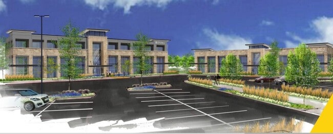
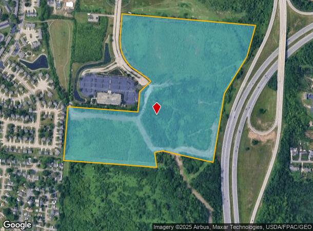
2601 Colonel Glenn Hwy
B42-0001-0003-0-0002-00
Beverly Gardens Subdivision
Commercialacreage
7-2-11 ESMNT 54.989 AC 4383 COL GLENN HWY
X
Greene
39057C0015D
Ohio
2023
54.99 AC
2024
East Dayton
200600
Cincinnati/Dayton
1,268 SF
Dayton, OH
DEMOGRAPHICS near 2601 Colonel Glenn Hwy
1 Mile
3 Mile
5 Mile
2024 Total Population
5,257
62,020
183,825
2029 Population
5,289
62,725
185,236
Pop Growth 2024-2029
+ 0.61%
+ 1.14%
+ 0.77%
Average Age
34
37
38
2024 Total Households
2,165
26,167
76,686
HH Growth 2024-2029
+ 0.83%
+ 1.16%
+ 0.79%
Median Household Inc
$71,454
$57,238
$58,285
Avg Household Size
2.40
2.30
2.20
2024 Avg HH Vehicles
2.00
2.00
2.00
Median Home Value
$138,842
$135,728
$145,621
Median Year Built
1974
1967
1962
Nearby Places
Map Layers
Map Styles
 Street
 Aerial
- Restaurants
- Banks
- Shops
- Fitness
- Groceries
PUBLIC TRANSPORTATION
AIRPORT
James M Cox Dayton International
DRIVE
WALK
Distance
James M Cox Dayton International
28 min
17.3 mi
Freight Ports
Port of Toledo
DRIVE
WALK
Distance
Port of Toledo
185 min
156.7 mi
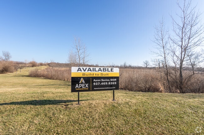
SALE & LEASE HISTORY
LISTING DATE
SALE/LEASE

Aug 25, 2020
For Lease
Nearby Properties
Address
Land Use
TOTAL SIZE
Lot Size
Zoning
Address
Land Use
TOTAL SIZE
Lot Size
Zoning
132,168 SF
128 AC
PD1
Address
Land Use
TOTAL SIZE
Lot Size
Zoning
259,051 SF
13.39 AC
Address
Land Use
TOTAL SIZE
Lot Size
Zoning
289,136 SF
69.81 AC
R2
Address
Land Use
TOTAL SIZE
Lot Size
Zoning
552,803 SF
29.77 AC
CPUD882
Address
Land Use
TOTAL SIZE
Lot Size
Zoning
316.77 AC
Address
Land Use
TOTAL SIZE
Lot Size
Zoning
33,504 SF
14 AC
Address
Land Use
TOTAL SIZE
Lot Size
Zoning
53.48 AC
RP1
Address
Land Use
TOTAL SIZE
Lot Size
Zoning
7,087 SF
31.93 AC
MX-PUD 93-
Address
Land Use
TOTAL SIZE
Lot Size
Zoning
107,570 SF
8.45 AC
Address
Land Use
TOTAL SIZE
Lot Size
Zoning
49,316 SF
30.39 AC
CPUD933
Address
Land Use
TOTAL SIZE
Lot Size
Zoning
130,247 SF
14.12 AC
Address
Land Use
TOTAL SIZE
Lot Size
Zoning
Address
Land Use
TOTAL SIZE
Lot Size
Zoning
133.37 AC
Address
Land Use
TOTAL SIZE
Lot Size
Zoning
3,243 SF
22.88 AC
R-PUD 97-3
Address
Land Use
TOTAL SIZE
Lot Size
Zoning
88,522 SF
12.96 AC
Address
Land Use
TOTAL SIZE
Lot Size
Zoning
46,796 SF
53.05 AC
RPUD038
Address
Land Use
TOTAL SIZE
Lot Size
Zoning
54.85 AC
Address
Land Use
TOTAL SIZE
Lot Size
Zoning
136,572 SF
5.59 AC
CPUD055
Address
Land Use
TOTAL SIZE
Lot Size
Zoning
46.32 AC
Address
Land Use
TOTAL SIZE
Lot Size
Zoning
32.30 AC
Address
Land Use
TOTAL SIZE
Lot Size
Zoning
47,424 SF
22.77 AC
RPUD917
Address
Land Use
TOTAL SIZE
Lot Size
Zoning
111,938 SF
10.03 AC
Address
Land Use
TOTAL SIZE
Lot Size
Zoning
2,376 SF
18.75 AC
PD1
Address
Land Use
TOTAL SIZE
Lot Size
Zoning
27,740 SF
11.16 AC
MXPUD93
Address
Land Use
TOTAL SIZE
Lot Size
Zoning
32,852 SF
18.80 AC
C-PUD 94-4
Address
Land Use
TOTAL SIZE
Lot Size
Zoning
96,732 SF
6.73 AC
CPUD002
Address
Land Use
TOTAL SIZE
Lot Size
Zoning
45,522 SF
10.22 AC
Address
Land Use
TOTAL SIZE
Lot Size
Zoning
18,576 SF
11.66 AC
Address
Land Use
TOTAL SIZE
Lot Size
Zoning
94,608 SF
7.44 AC
Address
Land Use
TOTAL SIZE
Lot Size
Zoning
121,392 SF
12.47 AC
The World's #1 Commercial Real Estate Marketplace
Connect with us
© 2025 CoStar Group
The information above has been obtained from sources believed reliable. While we do not doubt its accuracy we have not verified it and make no guarantee, warranty or representation about it. It is your responsibility to independently confirm its accuracy and completeness. Any projections, opinions, assumptions, or estimates used are for example only and do not represent the current or future performance of the property. The value of this transaction to you depends on tax and other factors which should be evaluated by your tax, financial, and legal advisors. You and your advisors should conduct a careful, independent investigation of the property to determine to your satisfaction the suitability of the property for your needs.