Property Record
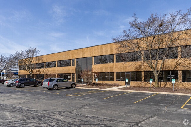
0 N Grandview Blvd, Waukesha, WI 53186

Current Lease Availabilities
NEARBY LISTINGS FOR SALE OR LEASE
Property Detail
0 N Grandview Blvd
Milwaukee-Waukesha-West Allis, WI
Certified Surv Map 7131
WAKC-0973-012
PARCEL 1 CSM NO 7131 (V60 CSM P140) PT NE1/4 SEC 28 T7N R19E.96 AC DOC NO 4432580
Commercialnec
Waukesha
X
Wisconsin
55133C0192H
1
2024
0.97 AC
2024
Central Waukesha
202800
Milwaukee/Madison
DEMOGRAPHICS near 0 N Grandview Blvd
1 Mile
3 Mile
5 Mile
2024 Total Population
6,431
56,816
112,743
2029 Population
6,665
58,712
116,390
Pop Growth 2024-2029
+ 3.64%
+ 3.34%
+ 3.23%
Average Age
41
41
41
2024 Total Households
2,785
24,743
48,010
HH Growth 2024-2029
+ 3.30%
+ 3.45%
+ 3.32%
Median Household Inc
$75,774
$74,325
$79,850
Avg Household Size
2.20
2.20
2.30
2024 Avg HH Vehicles
2.00
2.00
2.00
Median Home Value
$251,289
$267,878
$289,062
Median Year Built
1983
1980
1981
Nearby Places
- Restaurants
- Banks
- Shops
- Fitness
- Groceries
PUBLIC TRANSPORTATION
AIRPORT
General Mitchell International
DRIVE
WALK
Distance
General Mitchell International
37 min
24.3 mi
Freight Ports
Port Milwaukee
DRIVE
WALK
Distance
Port Milwaukee
29 min
20.9 mi
Nearby Properties
Address
Land Use
TOTAL SIZE
Lot Size
Zoning
Address
Land Use
TOTAL SIZE
Lot Size
Zoning
25.92 AC
Address
Land Use
TOTAL SIZE
Lot Size
Zoning
172.13 AC
M-2
Address
Land Use
TOTAL SIZE
Lot Size
Zoning
Address
Land Use
TOTAL SIZE
Lot Size
Zoning
56.81 AC
Address
Land Use
TOTAL SIZE
Lot Size
Zoning
Address
Land Use
TOTAL SIZE
Lot Size
Zoning
21.73 AC
M-1
Address
Land Use
TOTAL SIZE
Lot Size
Zoning
68,591 SF
2.97 AC
RM-3(PUD)
Address
Land Use
TOTAL SIZE
Lot Size
Zoning
Address
Land Use
TOTAL SIZE
Lot Size
Zoning
63,482 SF
39.53 AC
I-1
Address
Land Use
TOTAL SIZE
Lot Size
Zoning
237,267 SF
16.14 AC
B-5
Address
Land Use
TOTAL SIZE
Lot Size
Zoning
51,676 SF
7.41 AC
RM-3(PUD)
Address
Land Use
TOTAL SIZE
Lot Size
Zoning
51,676 SF
6.96 AC
RM-3(PUD)
Address
Land Use
TOTAL SIZE
Lot Size
Zoning
129,059 SF
19.19 AC
RM-2(PUD)
Address
Land Use
TOTAL SIZE
Lot Size
Zoning
Address
Land Use
TOTAL SIZE
Lot Size
Zoning
91,322 SF
8.48 AC
B-4
Address
Land Use
TOTAL SIZE
Lot Size
Zoning
110,992 SF
12.15 AC
RM-1(PUD)
Address
Land Use
TOTAL SIZE
Lot Size
Zoning
10.57 AC
Address
Land Use
TOTAL SIZE
Lot Size
Zoning
20.65 AC
Address
Land Use
TOTAL SIZE
Lot Size
Zoning
61,299 SF
6.59 AC
RM-2(PUD)
Address
Land Use
TOTAL SIZE
Lot Size
Zoning
28,942 SF
2.31 AC
B-3(22.52)
Address
Land Use
TOTAL SIZE
Lot Size
Zoning
79,529 SF
23.85 AC
I-1
Address
Land Use
TOTAL SIZE
Lot Size
Zoning
13.99 AC
Address
Land Use
TOTAL SIZE
Lot Size
Zoning
203,208 SF
41.18 AC
B-5,C-1
Address
Land Use
TOTAL SIZE
Lot Size
Zoning
24,981 SF
1.79 AC
B-3(22.52)
Address
Land Use
TOTAL SIZE
Lot Size
Zoning
12.28 AC
Address
Land Use
TOTAL SIZE
Lot Size
Zoning
11.54 AC
M-1
Address
Land Use
TOTAL SIZE
Lot Size
Zoning
65,803 SF
15.22 AC
RM-2(PUD),
Address
Land Use
TOTAL SIZE
Lot Size
Zoning
136.33 AC
M-2
Address
Land Use
TOTAL SIZE
Lot Size
Zoning
0.81 AC
B-2
Address
Land Use
TOTAL SIZE
Lot Size
Zoning
47,353 SF
5.41 AC
RM-2(PUD)
The World's #1 Commercial Real Estate Marketplace
Connect with us
© 2025 CoStar Group
The information above has been obtained from sources believed reliable. While we do not doubt its accuracy we have not verified it and make no guarantee, warranty or representation about it. It is your responsibility to independently confirm its accuracy and completeness. Any projections, opinions, assumptions, or estimates used are for example only and do not represent the current or future performance of the property. The value of this transaction to you depends on tax and other factors which should be evaluated by your tax, financial, and legal advisors. You and your advisors should conduct a careful, independent investigation of the property to determine to your satisfaction the suitability of the property for your needs.