Property Record
2620 River Road Dr, Waterloo, NE 68069

Save to a Folder
{{folder.Name}}
{{folder.ListingIds.length}} Properties
{{folder.ListingIds.length}} Property
Create a New Folder
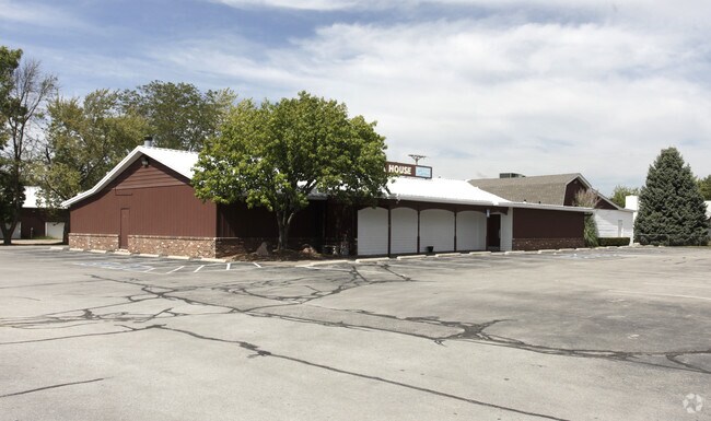
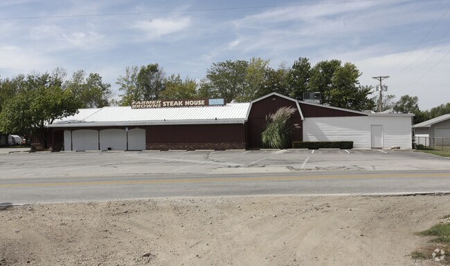
Property Detail
2620 River Road Dr
Omaha, NE-IA
WATERLOO OUT LOTS LOT 27 BLOCK 0 -EX S 338 FT- TRIANG PT ADJ SE COR OUT LOT 27 & BEING PT TAX LOT 18 NE 1/4 SW 1/4 & -EX S 338 FT- PT LYING SW CO RD 84 NW 1/4 SE 1/4 SEC 10-15-10 & IRREG S ESTLY 124 FT OUT LOT 27 1.12 AC
1359-0010-24
Douglas
Restaurantbuilding
Nebraska
2024
27
2025
1.12 AC
007508
Northwest Omaha
9,928 SF
Omaha/Council Bluffs
NEARBY LISTINGS FOR SALE OR LEASE
DEMOGRAPHICS near 2620 River Road Dr
1 mile
3 mile
5 mile
2025 Total Population
1,063
14,640
51,352
2030 Population
1,112
15,399
54,264
Pop Growth 2025-2030
+ 4.61%
+ 5.18%
+ 5.67%
Average Age
42
39
38
2025 Total Households
425
5,323
18,500
HH Growth 2025-2030
+ 4.94%
+ 5.45%
+ 5.79%
Median Household Inc
$97,463
$120,216
$141,481
Avg Household Size
2.50
2.70
2.70
2025 Avg HH Vehicles
2.00
2.00
2.00
Median Home Value
$327,500
$393,080
$473,177
Median Year Built
1978
2000
2009
Nearby Places
Map Layers
Map Styles
 Street
 Aerial
Layers
 Traffic
 Biking
Places
Listings with unknown addresses are not visible on the map
- Restaurants
- Banks
- Shops
- Fitness
- Groceries
PUBLIC TRANSPORTATION
AIRPORT
Eppley Airfield
Drive
Walk
Distance
Eppley Airfield
42 min
23.1 mi
Nearby Properties
Address
Land Use
TOTAL SIZE
Lot Size
Zoning
Address
Land Use
TOTAL SIZE
Lot Size
Zoning
441,099 SF
114.30 AC
Address
Land Use
TOTAL SIZE
Lot Size
Zoning
241,480 SF
9.54 AC
Address
Land Use
TOTAL SIZE
Lot Size
Zoning
272,916 SF
27.09 AC
Address
Land Use
TOTAL SIZE
Lot Size
Zoning
134,188 SF
6.05 AC
Address
Land Use
TOTAL SIZE
Lot Size
Zoning
164,725 SF
11.57 AC
Address
Land Use
TOTAL SIZE
Lot Size
Zoning
162,300 SF
17.46 AC
Address
Land Use
TOTAL SIZE
Lot Size
Zoning
144,006 SF
5.86 AC
Address
Land Use
TOTAL SIZE
Lot Size
Zoning
132,938 SF
7.76 AC
Address
Land Use
TOTAL SIZE
Lot Size
Zoning
106,857 SF
4.97 AC
Address
Land Use
TOTAL SIZE
Lot Size
Zoning
114,371 SF
3.12 AC
Address
Land Use
TOTAL SIZE
Lot Size
Zoning
117,761 SF
3.45 AC
Address
Land Use
TOTAL SIZE
Lot Size
Zoning
43,266 SF
2.01 AC
GC
Address
Land Use
TOTAL SIZE
Lot Size
Zoning
109,698 SF
4.35 AC
CC
Address
Land Use
TOTAL SIZE
Lot Size
Zoning
64,948 SF
4.87 AC
CC
Address
Land Use
TOTAL SIZE
Lot Size
Zoning
61,850 SF
1.31 AC
Address
Land Use
TOTAL SIZE
Lot Size
Zoning
83,958 SF
2.22 AC
Address
Land Use
TOTAL SIZE
Lot Size
Zoning
53,294 SF
3.27 AC
Address
Land Use
TOTAL SIZE
Lot Size
Zoning
53,864 SF
12.56 AC
Address
Land Use
TOTAL SIZE
Lot Size
Zoning
48,350 SF
3.08 AC
R6
Address
Land Use
TOTAL SIZE
Lot Size
Zoning
44,304 SF
4.21 AC
Address
Land Use
TOTAL SIZE
Lot Size
Zoning
86,480 SF
5.76 AC
Address
Land Use
TOTAL SIZE
Lot Size
Zoning
73,505 SF
4.09 AC
Address
Land Use
TOTAL SIZE
Lot Size
Zoning
87,298 SF
6.17 AC
Address
Land Use
TOTAL SIZE
Lot Size
Zoning
42,612 SF
3.99 AC
ELKHORN
Address
Land Use
TOTAL SIZE
Lot Size
Zoning
5,448 SF
1.14 AC
CC
Address
Land Use
TOTAL SIZE
Lot Size
Zoning
30,080 SF
4.06 AC
ELKHORN
Address
Land Use
TOTAL SIZE
Lot Size
Zoning
29,464 SF
2.75 AC
ELKHORN
Address
Land Use
TOTAL SIZE
Lot Size
Zoning
45,528 SF
206 AC
Address
Land Use
TOTAL SIZE
Lot Size
Zoning
32,665 SF
9.63 AC
Address
Land Use
TOTAL SIZE
Lot Size
Zoning
6,480 SF
1.06 AC
CC
The World's #1 Commercial Real Estate Marketplace
Connect with us
© 2026 CoStar Group
The information above has been obtained from sources believed reliable. While we do not doubt its accuracy we have not verified it and make no guarantee, warranty or representation about it. It is your responsibility to independently confirm its accuracy and completeness. Any projections, opinions, assumptions, or estimates used are for example only and do not represent the current or future performance of the property. The value of this transaction to you depends on tax and other factors which should be evaluated by your tax, financial, and legal advisors. You and your advisors should conduct a careful, independent investigation of the property to determine to your satisfaction the suitability of the property for your needs.