Property Record
2621 W Wackerly St, Midland, MI 48640

Save to a Folder
{{folder.Name}}
{{folder.ListingIds.length}} Properties
{{folder.ListingIds.length}} Property
Create a New Folder
Property Detail
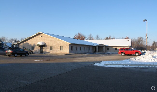
2621 W Wackerly St
14-05-80-014
LOTS 6 & 7, & THE WEST 67 FT OF LOT 5 SCHADE SUB
Officebuilding
Midland
OS
Michigan
B and X Area of moderate flood hazard, usually the area between the limits of the 100-year and 500-year floods.
5-7
2024
1.18 AC
2025
Midland/Flint
291000
Other Market Areas
14,050 SF
Midland, MI
NEARBY LISTINGS FOR SALE OR LEASE
DEMOGRAPHICS near 2621 W Wackerly St
1 mile
3 mile
5 mile
2025 Total Population
4,404
27,775
49,326
2030 Population
4,356
27,699
49,466
Pop Growth 2025-2030
(1.09%)
(0.27%)
+ 0.28%
Average Age
43
42
42
2025 Total Households
1,686
11,401
20,471
HH Growth 2025-2030
(1.07%)
(0.29%)
+ 0.34%
Median Household Inc
$114,194
$84,645
$76,748
Avg Household Size
2.60
2.40
2.30
2025 Avg HH Vehicles
2.00
2.00
2.00
Median Home Value
$268,970
$238,229
$215,068
Median Year Built
1976
1974
1973
Nearby Places
Map Layers
Map Styles
 Street
 Aerial
Layers
 Traffic
 Biking
Places
Listings with unknown addresses are not visible on the map
- Restaurants
- Banks
- Shops
- Fitness
- Groceries
PUBLIC TRANSPORTATION
AIRPORT
MBS International
Drive
Walk
Distance
MBS International
22 min
15.2 mi
Freight Ports
Port of Toledo
Drive
Walk
Distance
Port of Toledo
196 min
173.7 mi
SALE & LEASE HISTORY
LISTING DATE
SALE/LEASE

May 25, 2019
For Lease
Aug 24, 2020
For Lease
Nearby Properties
Address
Land Use
TOTAL SIZE
Lot Size
Zoning
Address
Land Use
TOTAL SIZE
Lot Size
Zoning
42,647 SF
12.42 AC
RA-4
Address
Land Use
TOTAL SIZE
Lot Size
Zoning
83,416 SF
1.21 AC
COM
Address
Land Use
TOTAL SIZE
Lot Size
Zoning
145,690 SF
1.69 AC
D
Address
Land Use
TOTAL SIZE
Lot Size
Zoning
116,057 SF
120 AC
RA-1
Address
Land Use
TOTAL SIZE
Lot Size
Zoning
252,442 SF
70.03 AC
AG
Address
Land Use
TOTAL SIZE
Lot Size
Zoning
357,933 SF
33.35 AC
RC
Address
Land Use
TOTAL SIZE
Lot Size
Zoning
116,274 SF
4.59 AC
RC
Address
Land Use
TOTAL SIZE
Lot Size
Zoning
223,029 SF
18.50 AC
OS
Address
Land Use
TOTAL SIZE
Lot Size
Zoning
201,174 SF
27.52 AC
RC
Address
Land Use
TOTAL SIZE
Lot Size
Zoning
207,859 SF
21.12 AC
RC
Address
Land Use
TOTAL SIZE
Lot Size
Zoning
55,872 SF
3.85 AC
RC
Address
Land Use
TOTAL SIZE
Lot Size
Zoning
61,516 SF
5.31 AC
RC
Address
Land Use
TOTAL SIZE
Lot Size
Zoning
53,950 SF
16.40 AC
RC
Address
Land Use
TOTAL SIZE
Lot Size
Zoning
55,926 SF
1.72 AC
CC
Address
Land Use
TOTAL SIZE
Lot Size
Zoning
124,265 SF
9.51 AC
RB
Address
Land Use
TOTAL SIZE
Lot Size
Zoning
64,769 SF
3.17 AC
RC
Address
Land Use
TOTAL SIZE
Lot Size
Zoning
81,009 SF
3.33 AC
RC
Address
Land Use
TOTAL SIZE
Lot Size
Zoning
74,532 SF
6.55 AC
RC
Address
Land Use
TOTAL SIZE
Lot Size
Zoning
88,104 SF
9 AC
RC
Address
Land Use
TOTAL SIZE
Lot Size
Zoning
62,440 SF
7.34 AC
RC
Address
Land Use
TOTAL SIZE
Lot Size
Zoning
104,458 SF
9.44 AC
RC
Address
Land Use
TOTAL SIZE
Lot Size
Zoning
36,082 SF
19.99 AC
RA-4
Address
Land Use
TOTAL SIZE
Lot Size
Zoning
38,127 SF
9.72 AC
IA
Address
Land Use
TOTAL SIZE
Lot Size
Zoning
35,826 SF
4.67 AC
RA-1
Address
Land Use
TOTAL SIZE
Lot Size
Zoning
100,336 SF
8.94 AC
RB
Address
Land Use
TOTAL SIZE
Lot Size
Zoning
82,050 SF
18.45 AC
IA
Address
Land Use
TOTAL SIZE
Lot Size
Zoning
102,455 SF
13.33 AC
RC
Address
Land Use
TOTAL SIZE
Lot Size
Zoning
114,465 SF
12.59 AC
RC
Address
Land Use
TOTAL SIZE
Lot Size
Zoning
52,037 SF
3.14 AC
OS
Address
Land Use
TOTAL SIZE
Lot Size
Zoning
33,828 SF
5.38 AC
RC
The World's #1 Commercial Real Estate Marketplace
Connect with us
© 2026 CoStar Group
The information above has been obtained from sources believed reliable. While we do not doubt its accuracy we have not verified it and make no guarantee, warranty or representation about it. It is your responsibility to independently confirm its accuracy and completeness. Any projections, opinions, assumptions, or estimates used are for example only and do not represent the current or future performance of the property. The value of this transaction to you depends on tax and other factors which should be evaluated by your tax, financial, and legal advisors. You and your advisors should conduct a careful, independent investigation of the property to determine to your satisfaction the suitability of the property for your needs.