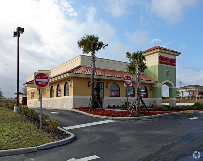
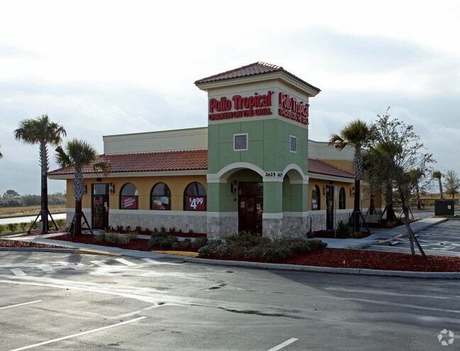
Property Record
2625 E Highway 50, Clermont, FL 34711

Property Detail
2625 E Highway 50
27-22-26-0100-000-00200
HANCOCK COMMONS PB 61 PG 87-88 LOT 2 ORB 5337 PG 2260 ORB 5339 PG 948
Autorepair
Lake
C2
Florida
B and X Area of moderate flood hazard, usually the area between the limits of the 100-year and 500-year floods.
2
2024
1.05 AC
2026
Lake County
031306
Orlando
8,905 SF
Orlando-Kissimmee-Sanford, FL
NEARBY LISTINGS FOR SALE OR LEASE
DEMOGRAPHICS near 2625 E Highway 50
1 mile
3 mile
5 mile
2025 Total Population
5,163
53,267
99,439
2030 Population
5,851
60,090
112,619
Pop Growth 2025-2030
+ 13.33%
+ 12.81%
+ 13.25%
Average Age
41
43
42
2025 Total Households
1,896
20,410
36,712
HH Growth 2025-2030
+ 13.55%
+ 12.92%
+ 13.34%
Median Household Inc
$105,496
$90,041
$94,722
Avg Household Size
2.70
2.60
2.70
2025 Avg HH Vehicles
2.00
2.00
2.00
Median Home Value
$436,942
$420,977
$437,840
Median Year Built
2005
2005
2004
Nearby Places
Map Layers
Map Styles
 Street
 Aerial
Layers
 Traffic
 Biking
Places
Listings with unknown addresses are not visible on the map
- Restaurants
- Banks
- Shops
- Fitness
- Groceries
PUBLIC TRANSPORTATION
AIRPORT
Orlando International
Drive
Walk
Distance
Orlando International
40 min
30.2 mi
Freight Ports
Port of Tampa Bay
Drive
Walk
Distance
Port of Tampa Bay
102 min
80.6 mi
Nearby Properties
Address
Land Use
TOTAL SIZE
Lot Size
Zoning
Address
Land Use
TOTAL SIZE
Lot Size
Zoning
425,675 SF
25.23 AC
Address
Land Use
TOTAL SIZE
Lot Size
Zoning
403,970 SF
30.99 AC
PUD
Address
Land Use
TOTAL SIZE
Lot Size
Zoning
337,218 SF
16.38 AC
Address
Land Use
TOTAL SIZE
Lot Size
Zoning
387,535 SF
22.94 AC
PUD
Address
Land Use
TOTAL SIZE
Lot Size
Zoning
285,581 SF
19.34 AC
CFD
Address
Land Use
TOTAL SIZE
Lot Size
Zoning
306,892 SF
21.96 AC
A
Address
Land Use
TOTAL SIZE
Lot Size
Zoning
326,899 SF
20.77 AC
Address
Land Use
TOTAL SIZE
Lot Size
Zoning
299,214 SF
25.01 AC
PUD
Address
Land Use
TOTAL SIZE
Lot Size
Zoning
321,012 SF
22.55 AC
PUD
Address
Land Use
TOTAL SIZE
Lot Size
Zoning
2,000 SF
35.96 AC
PUD
Address
Land Use
TOTAL SIZE
Lot Size
Zoning
269,594 SF
25.23 AC
PUD
Address
Land Use
TOTAL SIZE
Lot Size
Zoning
205,930 SF
Address
Land Use
TOTAL SIZE
Lot Size
Zoning
179,290 SF
23.79 AC
Address
Land Use
TOTAL SIZE
Lot Size
Zoning
212,649 SF
4.20 AC
Address
Land Use
TOTAL SIZE
Lot Size
Zoning
192,907 SF
16.43 AC
PUD
Address
Land Use
TOTAL SIZE
Lot Size
Zoning
2,000 SF
26.79 AC
PUD
Address
Land Use
TOTAL SIZE
Lot Size
Zoning
273,592 SF
91.55 AC
R6
Address
Land Use
TOTAL SIZE
Lot Size
Zoning
53,054 SF
11.65 AC
Address
Land Use
TOTAL SIZE
Lot Size
Zoning
53,982 SF
24.90 AC
Address
Land Use
TOTAL SIZE
Lot Size
Zoning
78,509 SF
18.68 AC
PUD
Address
Land Use
TOTAL SIZE
Lot Size
Zoning
52,986 SF
18.27 AC
Address
Land Use
TOTAL SIZE
Lot Size
Zoning
2,000 SF
30.62 AC
CFD
Address
Land Use
TOTAL SIZE
Lot Size
Zoning
2,000 SF
63.78 AC
Address
Land Use
TOTAL SIZE
Lot Size
Zoning
57,124 SF
7.58 AC
Address
Land Use
TOTAL SIZE
Lot Size
Zoning
106,799 SF
9.06 AC
MP
Address
Land Use
TOTAL SIZE
Lot Size
Zoning
124,634 SF
18.57 AC
Address
Land Use
TOTAL SIZE
Lot Size
Zoning
142,824 SF
9.90 AC
C2
Address
Land Use
TOTAL SIZE
Lot Size
Zoning
126,067 SF
9.34 AC
Address
Land Use
TOTAL SIZE
Lot Size
Zoning
62,897 SF
9.81 AC
MP
Address
Land Use
TOTAL SIZE
Lot Size
Zoning
62,794 SF
2.31 AC
The World's #1 Commercial Real Estate Marketplace
Connect with us
© 2026 CoStar Group
The information above has been obtained from sources believed reliable. While we do not doubt its accuracy we have not verified it and make no guarantee, warranty or representation about it. It is your responsibility to independently confirm its accuracy and completeness. Any projections, opinions, assumptions, or estimates used are for example only and do not represent the current or future performance of the property. The value of this transaction to you depends on tax and other factors which should be evaluated by your tax, financial, and legal advisors. You and your advisors should conduct a careful, independent investigation of the property to determine to your satisfaction the suitability of the property for your needs.