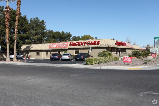
Property Record
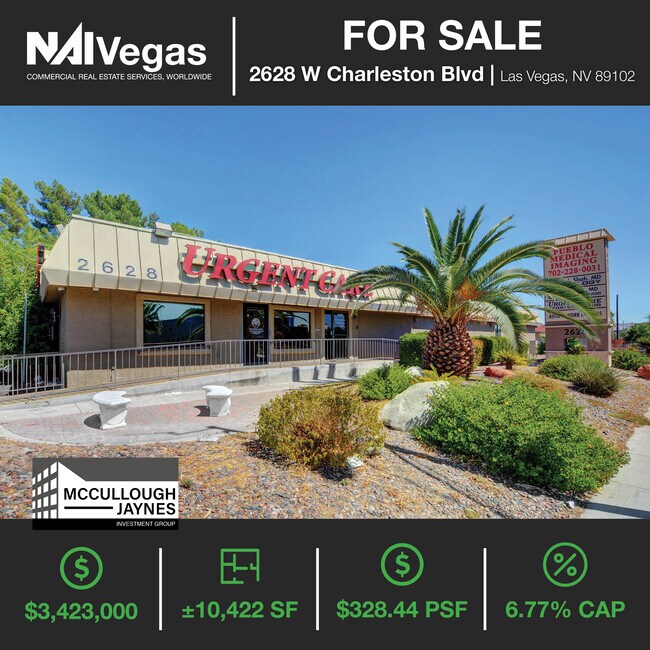
2628 W Charleston Blvd, Las Vegas, NV 89102

NEARBY LISTINGS FOR SALE OR LEASE
Property Detail
2628 W Charleston Blvd
139-32-802-027
PT SW4 SE4 SEC 32 20 61
Commercialnec
Clark
X
Nevada
32003C2170F
0.39 AC
2025
Northwest Las Vegas
2025
Las Vegas
001005
Las Vegas-Henderson-Paradise, NV
11,386 SF
DEMOGRAPHICS near 2628 W Charleston Blvd
1 Mile
3 Mile
5 Mile
2024 Total Population
10,078
173,683
506,433
2029 Population
10,882
187,521
544,226
Pop Growth 2024-2029
+ 7.98%
+ 7.97%
+ 7.46%
Average Age
45
39
38
2024 Total Households
4,312
69,907
194,225
HH Growth 2024-2029
+ 8.07%
+ 8.09%
+ 7.58%
Median Household Inc
$64,728
$38,332
$41,826
Avg Household Size
2.20
2.40
2.50
2024 Avg HH Vehicles
2.00
1.00
1.00
Median Home Value
$487,017
$284,099
$270,955
Median Year Built
1976
1978
1982
Nearby Places
Map Layers
Map Styles
 Street
 Aerial
- Restaurants
- Banks
- Shops
- Fitness
- Groceries
PUBLIC TRANSPORTATION
AIRPORT
Harry Reid International
DRIVE
WALK
Distance
Harry Reid International
14 min
7.0 mi
Boulder City Municipal
DRIVE
WALK
Distance
Boulder City Municipal
38 min
26.7 mi
SALE & LEASE HISTORY
LISTING DATE
SALE/LEASE

Sep 14, 2017
For Sale
Sep 13, 2017
For Sale
Sep 13, 2017
For Lease
Sep 07, 2017
For Sale
Oct 26, 2016
For Lease
Jul 28, 2018
For Sale
Jan 29, 2020
For Sale
Aug 28, 2017
For Sale
Nearby Properties
Address
Land Use
TOTAL SIZE
Lot Size
Zoning
Address
Land Use
TOTAL SIZE
Lot Size
Zoning
3,693,440 SF
43.59 AC
Address
Land Use
TOTAL SIZE
Lot Size
Zoning
3,391,505 SF
68.55 AC
Address
Land Use
TOTAL SIZE
Lot Size
Zoning
1,044,724 SF
56.56 AC
Address
Land Use
TOTAL SIZE
Lot Size
Zoning
1,172,527 SF
19.67 AC
H1
Address
Land Use
TOTAL SIZE
Lot Size
Zoning
1,494,289 SF
65.25 AC
H1
Address
Land Use
TOTAL SIZE
Lot Size
Zoning
8,805 SF
45.63 AC
Address
Land Use
TOTAL SIZE
Lot Size
Zoning
74,148 SF
18.51 AC
Address
Land Use
TOTAL SIZE
Lot Size
Zoning
248,689 SF
19.45 AC
H1
Address
Land Use
TOTAL SIZE
Lot Size
Zoning
171,303 SF
17.87 AC
H1
Address
Land Use
TOTAL SIZE
Lot Size
Zoning
315,865 SF
19.85 AC
Address
Land Use
TOTAL SIZE
Lot Size
Zoning
873,377 SF
28.08 AC
Address
Land Use
TOTAL SIZE
Lot Size
Zoning
1,345,377 SF
88.53 AC
H1
Address
Land Use
TOTAL SIZE
Lot Size
Zoning
79,707 SF
2.76 AC
Address
Land Use
TOTAL SIZE
Lot Size
Zoning
1,069,498 SF
28.36 AC
H1
Address
Land Use
TOTAL SIZE
Lot Size
Zoning
39,972 SF
3.04 AC
CV
Address
Land Use
TOTAL SIZE
Lot Size
Zoning
987,719 SF
12.98 AC
H1
Address
Land Use
TOTAL SIZE
Lot Size
Zoning
162,214 SF
4.32 AC
Address
Land Use
TOTAL SIZE
Lot Size
Zoning
126,656 SF
8.18 AC
H1
Address
Land Use
TOTAL SIZE
Lot Size
Zoning
497,331 SF
24.44 AC
Address
Land Use
TOTAL SIZE
Lot Size
Zoning
524,471 SF
59.01 AC
Address
Land Use
TOTAL SIZE
Lot Size
Zoning
162,501 SF
5.77 AC
C2
Address
Land Use
TOTAL SIZE
Lot Size
Zoning
34,354 SF
33.06 AC
Address
Land Use
TOTAL SIZE
Lot Size
Zoning
1,617,320 SF
7.21 AC
PD
Address
Land Use
TOTAL SIZE
Lot Size
Zoning
48.58 AC
PF
Address
Land Use
TOTAL SIZE
Lot Size
Zoning
115,059 SF
30.12 AC
Address
Land Use
TOTAL SIZE
Lot Size
Zoning
2.79 AC
CV
Address
Land Use
TOTAL SIZE
Lot Size
Zoning
611,832 SF
10 AC
Address
Land Use
TOTAL SIZE
Lot Size
Zoning
20,924 SF
17.50 AC
H1
Address
Land Use
TOTAL SIZE
Lot Size
Zoning
740,584 SF
0.98 AC
Address
Land Use
TOTAL SIZE
Lot Size
Zoning
24,965 SF
25.75 AC
The World's #1 Commercial Real Estate Marketplace
Connect with us
© 2025 CoStar Group
The information above has been obtained from sources believed reliable. While we do not doubt its accuracy we have not verified it and make no guarantee, warranty or representation about it. It is your responsibility to independently confirm its accuracy and completeness. Any projections, opinions, assumptions, or estimates used are for example only and do not represent the current or future performance of the property. The value of this transaction to you depends on tax and other factors which should be evaluated by your tax, financial, and legal advisors. You and your advisors should conduct a careful, independent investigation of the property to determine to your satisfaction the suitability of the property for your needs.