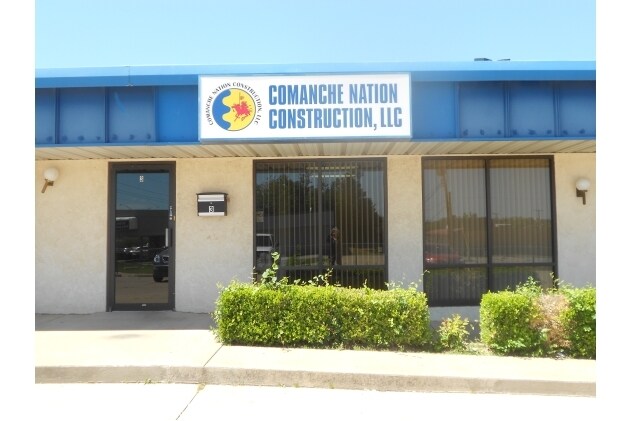
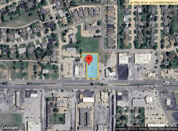
Property Record
2629 Nw Cache Rd, Lawton, OK 73505

NEARBY LISTINGS FOR SALE OR LEASE
Property Detail
2629 Nw Cache Rd
Lawton, OK
Morford Hills
0024314
MORFORD HILLS REPLAT LOT 1 BLK 15 PT 4) LOT 1D
Storesoffices
Comanche
X
Oklahoma
40031C0431E
1
2025
0.86 AC
2025
Oklahoma West Area
000600
Other Market Areas
10,750 SF
DEMOGRAPHICS near 2629 Nw Cache Rd
1 mile
3 mile
5 mile
2024 Total Population
11,477
61,503
86,942
2029 Population
11,977
63,895
89,961
Pop Growth 2024-2029
+ 4.36%
+ 3.89%
+ 3.47%
Average Age
38
36
36
2024 Total Households
4,769
24,583
32,478
HH Growth 2024-2029
+ 4.32%
+ 4.01%
+ 3.72%
Median Household Inc
$42,125
$40,766
$44,690
Avg Household Size
2.30
2.30
2.40
2024 Avg HH Vehicles
1.00
1.00
2.00
Median Home Value
$98,418
$113,105
$134,320
Median Year Built
1962
1969
1973
Nearby Places
Map Layers
Map Styles
 Street
 Aerial
Transit
 Traffic
 Biking
Places
Listings with unknown addresses are not visible on the map
- Restaurants
- Banks
- Shops
- Fitness
- Groceries
PUBLIC TRANSPORTATION
AIRPORT
Lawton-Fort Sill Regional
Drive
Walk
Distance
Lawton-Fort Sill Regional
12 min
4.9 mi
SALE & LEASE HISTORY
LISTING DATE
SALE/LEASE

Nov 01, 2023
For Lease
May 21, 2019
For Sale
May 04, 2018
For Sale
Feb 08, 2017
For Lease
Aug 08, 2023
For Lease
Apr 26, 2018
For Lease
Nearby Properties
Address
Land Use
TOTAL SIZE
Lot Size
Zoning
Address
Land Use
TOTAL SIZE
Lot Size
Zoning
36,063 SF
6.35 AC
Address
Land Use
TOTAL SIZE
Lot Size
Zoning
74,800 SF
4.77 AC
Address
Land Use
TOTAL SIZE
Lot Size
Zoning
2,288 SF
2.94 AC
Address
Land Use
TOTAL SIZE
Lot Size
Zoning
30,000 SF
17.22 AC
Address
Land Use
TOTAL SIZE
Lot Size
Zoning
25,930 SF
5.47 AC
Address
Land Use
TOTAL SIZE
Lot Size
Zoning
32,000 SF
5.32 AC
Address
Land Use
TOTAL SIZE
Lot Size
Zoning
22,987 SF
6.60 AC
Address
Land Use
TOTAL SIZE
Lot Size
Zoning
14,000 SF
17.18 AC
Address
Land Use
TOTAL SIZE
Lot Size
Zoning
9,240 SF
6.43 AC
Address
Land Use
TOTAL SIZE
Lot Size
Zoning
1,488 SF
19.48 AC
Address
Land Use
TOTAL SIZE
Lot Size
Zoning
13,326 SF
8.47 AC
Address
Land Use
TOTAL SIZE
Lot Size
Zoning
906 SF
5.51 AC
Address
Land Use
TOTAL SIZE
Lot Size
Zoning
114,352 SF
2.63 AC
Address
Land Use
TOTAL SIZE
Lot Size
Zoning
800 SF
15.64 AC
Address
Land Use
TOTAL SIZE
Lot Size
Zoning
195,881 SF
15.39 AC
Address
Land Use
TOTAL SIZE
Lot Size
Zoning
12,068 SF
5.31 AC
Address
Land Use
TOTAL SIZE
Lot Size
Zoning
35,582 SF
3.77 AC
Address
Land Use
TOTAL SIZE
Lot Size
Zoning
16,996 SF
12.16 AC
Address
Land Use
TOTAL SIZE
Lot Size
Zoning
25,800 SF
3.82 AC
Address
Land Use
TOTAL SIZE
Lot Size
Zoning
2,376 SF
8.64 AC
Address
Land Use
TOTAL SIZE
Lot Size
Zoning
123,414 SF
17.50 AC
Address
Land Use
TOTAL SIZE
Lot Size
Zoning
3,860 SF
7.41 AC
Address
Land Use
TOTAL SIZE
Lot Size
Zoning
117,301 SF
13.84 AC
Address
Land Use
TOTAL SIZE
Lot Size
Zoning
63,224 SF
2.66 AC
Address
Land Use
TOTAL SIZE
Lot Size
Zoning
82,509 SF
6.29 AC
Address
Land Use
TOTAL SIZE
Lot Size
Zoning
24,756 SF
2.39 AC
Address
Land Use
TOTAL SIZE
Lot Size
Zoning
2,688 SF
4.50 AC
Address
Land Use
TOTAL SIZE
Lot Size
Zoning
50,002 SF
7.66 AC
Address
Land Use
TOTAL SIZE
Lot Size
Zoning
41,192 SF
6.61 AC
Address
Land Use
TOTAL SIZE
Lot Size
Zoning
57,096 SF
16.03 AC
The World's #1 Commercial Real Estate Marketplace
Connect with us
© 2026 CoStar Group
The information above has been obtained from sources believed reliable. While we do not doubt its accuracy we have not verified it and make no guarantee, warranty or representation about it. It is your responsibility to independently confirm its accuracy and completeness. Any projections, opinions, assumptions, or estimates used are for example only and do not represent the current or future performance of the property. The value of this transaction to you depends on tax and other factors which should be evaluated by your tax, financial, and legal advisors. You and your advisors should conduct a careful, independent investigation of the property to determine to your satisfaction the suitability of the property for your needs.