Property Record
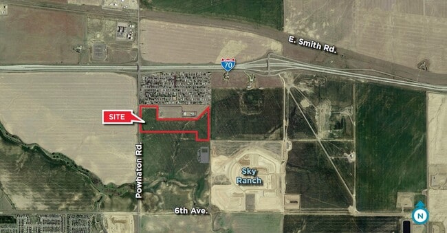
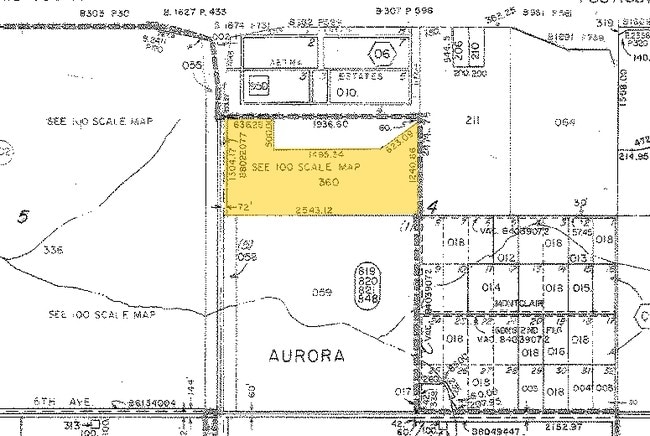
26500 E 10Th Ave, Aurora, CO 80018

This Property Is For Sale
Property Detail
26500 E 10Th Ave
1977-00-0-00-360
SECTION 04 TOWNSHIP 04 RANGE 65 THAT PART OF THE S 1/2 OF THE NW 1/4 OF SEC 4-4-65 DESC AS BEG 72 FT E OF THE W 1/4 COR OF SD SEC TH E 2543.12 FT TH N 1240.66 FT TH SW 623.09 FT TH W 1495.34 FT TH N 500 FT TH W 636.28 FT TO A PT 72 FT E OF THE W LINE
Farms
ARAPAHOE
AA1
Colorado
B and X Area of moderate flood hazard, usually the area between the limits of the 100-year and 500-year floods.
56.84 AC
2024
Outlying Arapahoe County
2025
Denver
007108
Denver-Aurora-Centennial, CO
NEARBY LISTINGS FOR SALE OR LEASE
DEMOGRAPHICS near 26500 E 10Th Ave
1 mile
3 mile
5 mile
2025 Total Population
2,598
15,594
35,776
2030 Population
2,914
17,182
38,830
Pop Growth 2025-2030
+ 12.16%
+ 10.18%
+ 8.54%
Average Age
34
36
36
2025 Total Households
766
4,731
10,603
HH Growth 2025-2030
+ 12.01%
+ 9.74%
+ 8.17%
Median Household Inc
$108,482
$127,991
$119,248
Avg Household Size
3.20
3.10
3.10
2025 Avg HH Vehicles
2.00
2.00
2.00
Median Home Value
$683,117
$695,055
$613,922
Median Year Built
2011
2011
2009
Nearby Places
Map Layers
Map Styles
 Street
 Aerial
Transit
 Traffic
 Biking
Places
Listings with unknown addresses are not visible on the map
- Restaurants
- Banks
- Shops
- Fitness
- Groceries
PUBLIC TRANSPORTATION
COMMUTER RAIL
40Th Ave & Airport Blvd - Gateway Park Station Track 2 (Union Station to Denver Airport Station - Regional Transportation District)
Drive
Walk
Distance
40Th Ave & Airport Blvd - Gateway Park Station Track 2 (Union Station to Denver Airport Station - Regional Transportation District)
14 min
7.5 mi
61St & Pena Station Track 2 (Union Station to Denver Airport Station - Regional Transportation District)
Drive
Walk
Distance
61St & Pena Station Track 2 (Union Station to Denver Airport Station - Regional Transportation District)
17 min
10.0 mi
AIRPORT
Denver International
Drive
Walk
Distance
Denver International
21 min
15.3 mi
Freight Ports
Tulsa Port Of Catoosa
Drive
Walk
Distance
Tulsa Port Of Catoosa
707 min
690.6 mi
Nearby Properties
Address
Land Use
TOTAL SIZE
Lot Size
Zoning
Address
Land Use
TOTAL SIZE
Lot Size
Zoning
355,937 SF
19.66 AC
RPD
Address
Land Use
TOTAL SIZE
Lot Size
Zoning
1,016,116 SF
69.40 AC
Address
Land Use
TOTAL SIZE
Lot Size
Zoning
632,815 SF
34.66 AC
A3
Address
Land Use
TOTAL SIZE
Lot Size
Zoning
239,230 SF
100.06 AC
AAE
Address
Land Use
TOTAL SIZE
Lot Size
Zoning
517,368 SF
29.74 AC
Address
Land Use
TOTAL SIZE
Lot Size
Zoning
404,800 SF
23.17 AC
Address
Land Use
TOTAL SIZE
Lot Size
Zoning
112.24 AC
Address
Land Use
TOTAL SIZE
Lot Size
Zoning
357,850 SF
19.15 AC
Address
Land Use
TOTAL SIZE
Lot Size
Zoning
334,601 SF
25.93 AC
Address
Land Use
TOTAL SIZE
Lot Size
Zoning
220,000 SF
17.22 AC
Address
Land Use
TOTAL SIZE
Lot Size
Zoning
348,536 SF
77.27 AC
Address
Land Use
TOTAL SIZE
Lot Size
Zoning
284,568 SF
15.72 AC
Address
Land Use
TOTAL SIZE
Lot Size
Zoning
209,116 SF
18.22 AC
Address
Land Use
TOTAL SIZE
Lot Size
Zoning
250,536 SF
15.31 AC
Address
Land Use
TOTAL SIZE
Lot Size
Zoning
163,386 SF
10.02 AC
Address
Land Use
TOTAL SIZE
Lot Size
Zoning
183,787 SF
Address
Land Use
TOTAL SIZE
Lot Size
Zoning
109.99 AC
Address
Land Use
TOTAL SIZE
Lot Size
Zoning
80.12 AC
Address
Land Use
TOTAL SIZE
Lot Size
Zoning
20.42 AC
Address
Land Use
TOTAL SIZE
Lot Size
Zoning
1,320 SF
70.73 AC
Address
Land Use
TOTAL SIZE
Lot Size
Zoning
44,156 SF
25.31 AC
Address
Land Use
TOTAL SIZE
Lot Size
Zoning
183,787 SF
14.78 AC
AA1
Address
Land Use
TOTAL SIZE
Lot Size
Zoning
57.83 AC
Address
Land Use
TOTAL SIZE
Lot Size
Zoning
57.42 AC
Address
Land Use
TOTAL SIZE
Lot Size
Zoning
9.26 AC
AA2
Address
Land Use
TOTAL SIZE
Lot Size
Zoning
19.43 AC
Address
Land Use
TOTAL SIZE
Lot Size
Zoning
5,075 SF
1.24 AC
Address
Land Use
TOTAL SIZE
Lot Size
Zoning
30.65 AC
The World's #1 Commercial Real Estate Marketplace
Connect with us
© 2026 CoStar Group
The information above has been obtained from sources believed reliable. While we do not doubt its accuracy we have not verified it and make no guarantee, warranty or representation about it. It is your responsibility to independently confirm its accuracy and completeness. Any projections, opinions, assumptions, or estimates used are for example only and do not represent the current or future performance of the property. The value of this transaction to you depends on tax and other factors which should be evaluated by your tax, financial, and legal advisors. You and your advisors should conduct a careful, independent investigation of the property to determine to your satisfaction the suitability of the property for your needs.