Property Record
2651 Sw Waterside Way, Stuart, FL 34997


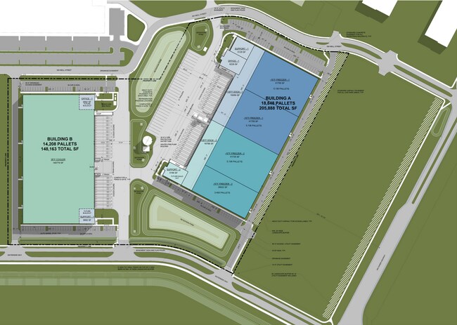
This Property Is For Sale
Property Detail
2651 Sw Waterside Way
Port St. Lucie, FL
LOT C-1 SOUTH FLORIDA GATEWAY PUD-C-LOTS (PB 19/90)
13-39-40-010-000-00010-0
MARTIN
Warehouse
Florida
B and X Area of moderate flood hazard, usually the area between the limits of the 100-year and 500-year floods.
c-1
2024
20.76 AC
2025
Martin Inland
001107
Port St Lucie/Fort Pierce
NEARBY LISTINGS FOR SALE OR LEASE
DEMOGRAPHICS near 2651 Sw Waterside Way
1 mile
3 mile
5 mile
2025 Total Population
471
7,243
15,480
2030 Population
475
7,410
15,831
Pop Growth 2025-2030
+ 0.85%
+ 2.31%
+ 2.27%
Average Age
46
48
47
2025 Total Households
186
2,893
6,080
HH Growth 2025-2030
+ 0.54%
+ 2.04%
+ 2.01%
Median Household Inc
$92,592
$89,093
$97,590
Avg Household Size
2.40
2.40
2.40
2025 Avg HH Vehicles
2.00
2.00
2.00
Median Home Value
$349,193
$464,950
$521,632
Median Year Built
1996
1997
1996
Nearby Places
Map Layers
Map Styles
 Street
 Aerial
Layers
 Traffic
 Biking
Places
Listings with unknown addresses are not visible on the map
- Restaurants
- Banks
- Shops
- Fitness
- Groceries
PUBLIC TRANSPORTATION
AIRPORT
Palm Beach International
Drive
Walk
Distance
Palm Beach International
47 min
37.9 mi
Freight Ports
Port of Palm Beach
Drive
Walk
Distance
Port of Palm Beach
41 min
31.6 mi
Nearby Properties
Address
Land Use
TOTAL SIZE
Lot Size
Zoning
Address
Land Use
TOTAL SIZE
Lot Size
Zoning
49.11 AC
Address
Land Use
TOTAL SIZE
Lot Size
Zoning
6,510 SF
1,216.20 AC
A2
Address
Land Use
TOTAL SIZE
Lot Size
Zoning
16.75 AC
Address
Land Use
TOTAL SIZE
Lot Size
Zoning
17.29 AC
Address
Land Use
TOTAL SIZE
Lot Size
Zoning
752.94 AC
AG20A
Address
Land Use
TOTAL SIZE
Lot Size
Zoning
39,801 SF
8.50 AC
LI
Address
Land Use
TOTAL SIZE
Lot Size
Zoning
97,783 SF
6.34 AC
LI
Address
Land Use
TOTAL SIZE
Lot Size
Zoning
190,638 SF
147 AC
A1
Address
Land Use
TOTAL SIZE
Lot Size
Zoning
2,050 SF
386.34 AC
AG20A
Address
Land Use
TOTAL SIZE
Lot Size
Zoning
5.52 AC
LI
Address
Land Use
TOTAL SIZE
Lot Size
Zoning
44,712 SF
15.18 AC
PS2
Address
Land Use
TOTAL SIZE
Lot Size
Zoning
47,906 SF
21.36 AC
RE2A
Address
Land Use
TOTAL SIZE
Lot Size
Zoning
39,555 SF
2.47 AC
PUDC
Address
Land Use
TOTAL SIZE
Lot Size
Zoning
248.21 AC
A1
Address
Land Use
TOTAL SIZE
Lot Size
Zoning
51,969 SF
16.19 AC
GI
Address
Land Use
TOTAL SIZE
Lot Size
Zoning
2.99 AC
LI
Address
Land Use
TOTAL SIZE
Lot Size
Zoning
28,488 SF
181.84 AC
PR
Address
Land Use
TOTAL SIZE
Lot Size
Zoning
53,801 SF
7.30 AC
WGC
Address
Land Use
TOTAL SIZE
Lot Size
Zoning
80,989 SF
31.75 AC
A1
Address
Land Use
TOTAL SIZE
Lot Size
Zoning
52,800 SF
3.78 AC
LI
Address
Land Use
TOTAL SIZE
Lot Size
Zoning
29,700 SF
2.01 AC
LI
Address
Land Use
TOTAL SIZE
Lot Size
Zoning
36,000 SF
2.79 AC
LI
Address
Land Use
TOTAL SIZE
Lot Size
Zoning
27,209 SF
5.68 AC
M2
Address
Land Use
TOTAL SIZE
Lot Size
Zoning
62,120 SF
4.99 AC
LC
Address
Land Use
TOTAL SIZE
Lot Size
Zoning
29.60 AC
Address
Land Use
TOTAL SIZE
Lot Size
Zoning
18,220 SF
1.83 AC
Address
Land Use
TOTAL SIZE
Lot Size
Zoning
21,600 SF
1.57 AC
LI
Address
Land Use
TOTAL SIZE
Lot Size
Zoning
32.26 AC
Address
Land Use
TOTAL SIZE
Lot Size
Zoning
17,042 SF
1.09 AC
The World's #1 Commercial Real Estate Marketplace
Connect with us
© 2026 CoStar Group
The information above has been obtained from sources believed reliable. While we do not doubt its accuracy we have not verified it and make no guarantee, warranty or representation about it. It is your responsibility to independently confirm its accuracy and completeness. Any projections, opinions, assumptions, or estimates used are for example only and do not represent the current or future performance of the property. The value of this transaction to you depends on tax and other factors which should be evaluated by your tax, financial, and legal advisors. You and your advisors should conduct a careful, independent investigation of the property to determine to your satisfaction the suitability of the property for your needs.