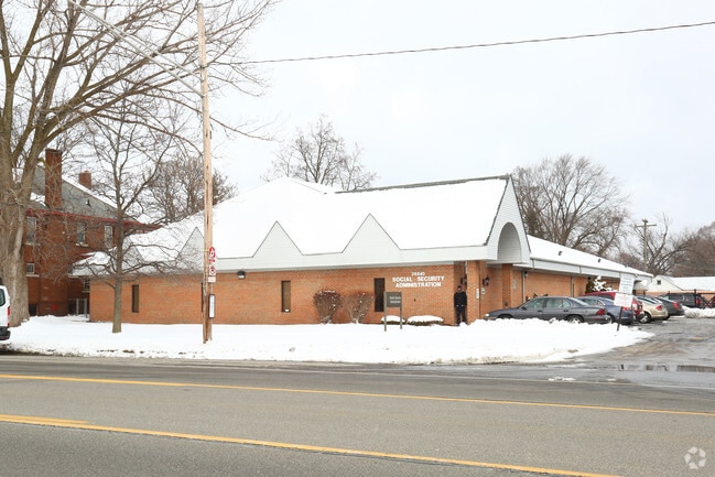
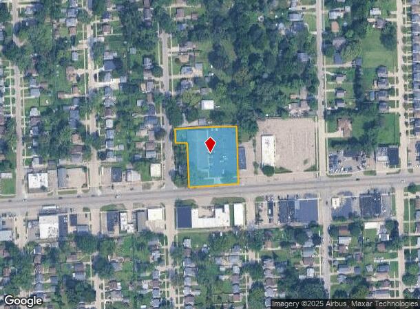
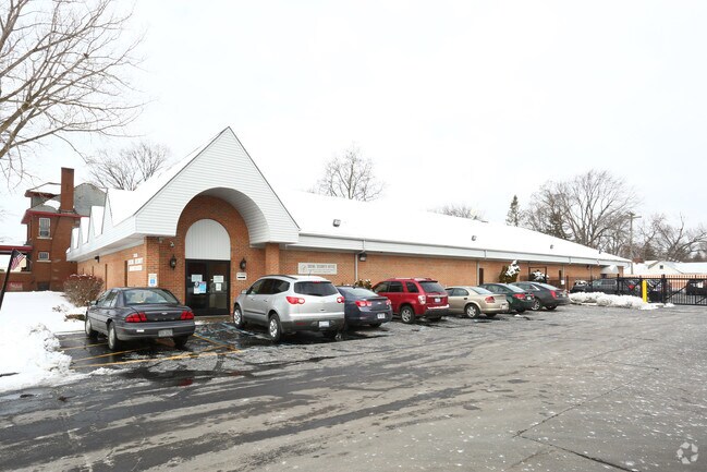
Property Record
26840 W 7 Mile Rd, Redford, MI 48240
NEARBY LISTINGS FOR SALE OR LEASE
Property Detail
26840 W 7 Mile Rd
Detroit-Warren-Dearborn, MI
Liberty Heights
79-005-01-0127-301
06J127, 128A C2 LOT 127 ALSO W 55 FT OF LOT 128 LIBERTY HEIGHTS SUB T1S R8E L69 P61 WCR ALSO PT OF SW 1/4 OF SEC 06 T1S R8E DESC AS BEG AT SW COR OF LOT 127 TH S 88D 20M W 69 FT TH N 01D E 186 FT TH S 88D 20M W 50 FT TH N 01D E 60 FT TH N 88D 20M E 1
Officebuilding
Wayne
X
Michigan
26163C0066E
127-128
2024
1.27 AC
2025
Southern I-275 Corridor
554200
Detroit
13,760 SF
DEMOGRAPHICS near 26840 W 7 Mile Rd
1 Mile
3 Mile
5 Mile
2024 Total Population
14,224
89,295
242,919
2029 Population
13,649
86,615
236,351
Pop Growth 2024-2029
(4.04%)
(3.00%)
(2.70%)
Average Age
39
41
41
2024 Total Households
5,695
37,618
101,528
HH Growth 2024-2029
(4.09%)
(3.03%)
(2.71%)
Median Household Inc
$60,149
$58,256
$60,769
Avg Household Size
2.40
2.30
2.30
2024 Avg HH Vehicles
2.00
2.00
2.00
Median Home Value
$129,891
$155,441
$171,653
Median Year Built
1954
1957
1958
Nearby Places
Map Layers
Map Styles
 Street
 Aerial
- Restaurants
- Banks
- Shops
- Fitness
- Groceries
PUBLIC TRANSPORTATION
AIRPORT
Detroit Metro Wayne County
DRIVE
WALK
Distance
Detroit Metro Wayne County
35 min
27.0 mi
Windsor International
DRIVE
WALK
Distance
Windsor International
47 min
28.5 mi
Freight Ports
Port of Toledo
DRIVE
WALK
Distance
Port of Toledo
85 min
68.6 mi
Nearby Properties
Address
Land Use
TOTAL SIZE
Lot Size
Zoning
Address
Land Use
TOTAL SIZE
Lot Size
Zoning
383,602 SF
36.60 AC
I-1
Address
Land Use
TOTAL SIZE
Lot Size
Zoning
311,298 SF
31.66 AC
BI
Address
Land Use
TOTAL SIZE
Lot Size
Zoning
397,200 SF
14.07 AC
RMU
Address
Land Use
TOTAL SIZE
Lot Size
Zoning
192,755 SF
Address
Land Use
TOTAL SIZE
Lot Size
Zoning
137,490 SF
12.16 AC
C-2
Address
Land Use
TOTAL SIZE
Lot Size
Zoning
164,964 SF
14.96 AC
R-7
Address
Land Use
TOTAL SIZE
Lot Size
Zoning
158,092 SF
11.75 AC
B-3
Address
Land Use
TOTAL SIZE
Lot Size
Zoning
204 SF
11.31 AC
RM
Address
Land Use
TOTAL SIZE
Lot Size
Zoning
138,104 SF
8.66 AC
AI
Address
Land Use
TOTAL SIZE
Lot Size
Zoning
143,941 SF
11.66 AC
PD
Address
Land Use
TOTAL SIZE
Lot Size
Zoning
192,038 SF
16.26 AC
C-2
Address
Land Use
TOTAL SIZE
Lot Size
Zoning
115,270 SF
7.07 AC
AI
Address
Land Use
TOTAL SIZE
Lot Size
Zoning
104,567 SF
2.14 AC
PD
Address
Land Use
TOTAL SIZE
Lot Size
Zoning
142,058 SF
10.02 AC
R-7
Address
Land Use
TOTAL SIZE
Lot Size
Zoning
152 SF
7.32 AC
RM
Address
Land Use
TOTAL SIZE
Lot Size
Zoning
9.07 AC
R-7
Address
Land Use
TOTAL SIZE
Lot Size
Zoning
Address
Land Use
TOTAL SIZE
Lot Size
Zoning
137,658 SF
18.37 AC
I-L
Address
Land Use
TOTAL SIZE
Lot Size
Zoning
129,711 SF
10.28 AC
R-7
Address
Land Use
TOTAL SIZE
Lot Size
Zoning
112,344 SF
2.51 AC
II
Address
Land Use
TOTAL SIZE
Lot Size
Zoning
37,030 SF
4.47 AC
C-2
Address
Land Use
TOTAL SIZE
Lot Size
Zoning
53,157 SF
2.86 AC
C-1
Address
Land Use
TOTAL SIZE
Lot Size
Zoning
43,140 SF
10.41 AC
C-2
Address
Land Use
TOTAL SIZE
Lot Size
Zoning
99,154 SF
7.04 AC
AI
Address
Land Use
TOTAL SIZE
Lot Size
Zoning
79,340 SF
3.20 AC
PD
Address
Land Use
TOTAL SIZE
Lot Size
Zoning
381,559 SF
21.08 AC
C-2
Address
Land Use
TOTAL SIZE
Lot Size
Zoning
76,117 SF
5.57 AC
R-9
Address
Land Use
TOTAL SIZE
Lot Size
Zoning
104 SF
8.93 AC
RM
Address
Land Use
TOTAL SIZE
Lot Size
Zoning
76,117 SF
5.50 AC
R-9
Address
Land Use
TOTAL SIZE
Lot Size
Zoning
110,242 SF
4.75 AC
The World's #1 Commercial Real Estate Marketplace
Connect with us
© 2025 CoStar Group
The information above has been obtained from sources believed reliable. While we do not doubt its accuracy we have not verified it and make no guarantee, warranty or representation about it. It is your responsibility to independently confirm its accuracy and completeness. Any projections, opinions, assumptions, or estimates used are for example only and do not represent the current or future performance of the property. The value of this transaction to you depends on tax and other factors which should be evaluated by your tax, financial, and legal advisors. You and your advisors should conduct a careful, independent investigation of the property to determine to your satisfaction the suitability of the property for your needs.