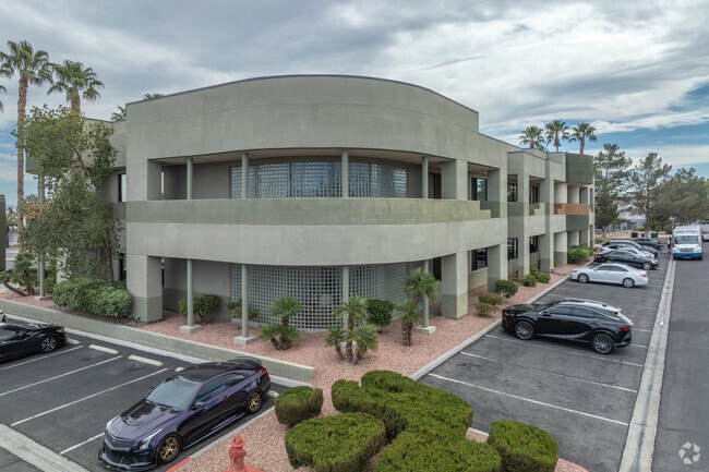
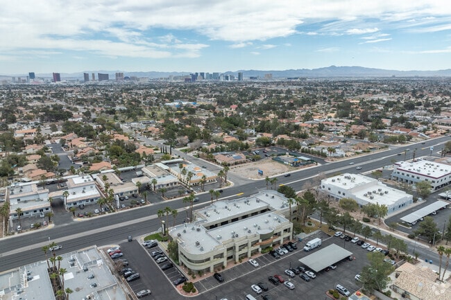
Property Record
2685 S Rainbow Blvd, Las Vegas, NV 89146


NEARBY LISTINGS FOR SALE OR LEASE
Property Detail
2685 S Rainbow Blvd
Las Vegas-Henderson-Paradise, NV
Parcel Map File 49 Page 17
163-10-508-003
PARCEL MAP FILE 49 PAGE 17 LOT 2
Commercialnec
Clark
X
Nevada
32003C2165D
2
2025
2.05 AC
2025
West Las Vegas
002939
Las Vegas
30,380 SF
DEMOGRAPHICS near 2685 S Rainbow Blvd
1 Mile
3 Mile
5 Mile
2024 Total Population
7,578
204,143
466,141
2029 Population
8,114
219,201
501,801
Pop Growth 2024-2029
+ 7.07%
+ 7.38%
+ 7.65%
Average Age
45
40
40
2024 Total Households
2,845
79,416
187,655
HH Growth 2024-2029
+ 7.03%
+ 7.34%
+ 7.75%
Median Household Inc
$73,203
$48,586
$55,676
Avg Household Size
2.50
2.50
2.40
2024 Avg HH Vehicles
2.00
2.00
2.00
Median Home Value
$528,058
$308,478
$350,447
Median Year Built
1984
1985
1991
Nearby Places
- Restaurants
- Banks
- Shops
- Fitness
- Groceries
PUBLIC TRANSPORTATION
AIRPORT
Harry Reid International
DRIVE
WALK
Distance
Harry Reid International
17 min
9.2 mi
Boulder City Municipal
DRIVE
WALK
Distance
Boulder City Municipal
43 min
30.3 mi
Freight Ports
Port of Long Beach
DRIVE
WALK
Distance
Port of Long Beach
319 min
284.4 mi
SALE & LEASE HISTORY
LISTING DATE
SALE/LEASE

Sep 24, 2016
For Lease
Feb 25, 2020
For Lease
Dec 27, 2016
For Lease
Dec 06, 2016
For Lease
Nearby Properties
Address
Land Use
TOTAL SIZE
Lot Size
Zoning
Address
Land Use
TOTAL SIZE
Lot Size
Zoning
40 AC
PF
Address
Land Use
TOTAL SIZE
Lot Size
Zoning
408,908 SF
15.60 AC
Address
Land Use
TOTAL SIZE
Lot Size
Zoning
Address
Land Use
TOTAL SIZE
Lot Size
Zoning
Address
Land Use
TOTAL SIZE
Lot Size
Zoning
12.23 AC
PF
Address
Land Use
TOTAL SIZE
Lot Size
Zoning
28,956 SF
75.82 AC
CV
Address
Land Use
TOTAL SIZE
Lot Size
Zoning
4,872 SF
18.22 AC
R3
Address
Land Use
TOTAL SIZE
Lot Size
Zoning
3.61 AC
PF
Address
Land Use
TOTAL SIZE
Lot Size
Zoning
8,261 SF
9.36 AC
Address
Land Use
TOTAL SIZE
Lot Size
Zoning
271,484 SF
7.04 AC
C2
Address
Land Use
TOTAL SIZE
Lot Size
Zoning
322,005 SF
29.37 AC
C1
Address
Land Use
TOTAL SIZE
Lot Size
Zoning
3,020 SF
19.68 AC
L:R-PD23
Address
Land Use
TOTAL SIZE
Lot Size
Zoning
181,262 SF
16.63 AC
L:C-2
Address
Land Use
TOTAL SIZE
Lot Size
Zoning
6,558 SF
23.36 AC
R3
Address
Land Use
TOTAL SIZE
Lot Size
Zoning
52,058 SF
6.44 AC
C1
Address
Land Use
TOTAL SIZE
Lot Size
Zoning
66.57 AC
CV
Address
Land Use
TOTAL SIZE
Lot Size
Zoning
285,929 SF
5.06 AC
C1
Address
Land Use
TOTAL SIZE
Lot Size
Zoning
2,694 SF
14.11 AC
L:R-PD23
Address
Land Use
TOTAL SIZE
Lot Size
Zoning
5,818 SF
14.55 AC
R4
Address
Land Use
TOTAL SIZE
Lot Size
Zoning
6,037 SF
15.12 AC
R3
Address
Land Use
TOTAL SIZE
Lot Size
Zoning
4,721 SF
18.14 AC
R4
Address
Land Use
TOTAL SIZE
Lot Size
Zoning
Address
Land Use
TOTAL SIZE
Lot Size
Zoning
16,491 SF
25.25 AC
C1
Address
Land Use
TOTAL SIZE
Lot Size
Zoning
3,200 SF
35 AC
PF
Address
Land Use
TOTAL SIZE
Lot Size
Zoning
1,838 SF
24.69 AC
R3
Address
Land Use
TOTAL SIZE
Lot Size
Zoning
186,867 SF
3.19 AC
L:C-1
Address
Land Use
TOTAL SIZE
Lot Size
Zoning
3,239 SF
11.76 AC
R3
Address
Land Use
TOTAL SIZE
Lot Size
Zoning
4,729 SF
13.01 AC
R3
Address
Land Use
TOTAL SIZE
Lot Size
Zoning
8.28 AC
PF
Address
Land Use
TOTAL SIZE
Lot Size
Zoning
5,171 SF
4.24 AC
RPD14
The World's #1 Commercial Real Estate Marketplace
Connect with us
© 2025 CoStar Group
The information above has been obtained from sources believed reliable. While we do not doubt its accuracy we have not verified it and make no guarantee, warranty or representation about it. It is your responsibility to independently confirm its accuracy and completeness. Any projections, opinions, assumptions, or estimates used are for example only and do not represent the current or future performance of the property. The value of this transaction to you depends on tax and other factors which should be evaluated by your tax, financial, and legal advisors. You and your advisors should conduct a careful, independent investigation of the property to determine to your satisfaction the suitability of the property for your needs.